
Elk Grove is a city in Sacramento County, California, United States. Located just south of the state capital of Sacramento, it is part of the Sacramento metropolitan area. As of the 2020 Census, the population of the city was 176,124. A 2021 Census estimate puts the population of the city at 187,985. Elk Grove has many wineries, wine cellars, and vineyards. Elk Grove was the fastest-growing city in the U.S. between July 1, 2004, and July 1, 2005, and is also presently the second-largest city in Sacramento County by population.
The Sacramento Regional Transit District, commonly referred to as SacRT, is the agency responsible for public transportation in the Sacramento, California area. It was established on April 1, 1973, as a result of the acquisition of the Sacramento Transit Authority. In addition to operating over 81 bus routes with connecting bus service in the Sacramento area covering 438 square miles (1,134.4 km2), SacRT also operates a large light rail system, which ranks currently as the sixteenth busiest light rail system in the United States. In 2023, the system had a ridership of 15,836,400, or about 54,500 per weekday as of the second quarter of 2024.

Sacramento Valley Station is an Amtrak railway station in the city of Sacramento, California, at 401 I Street on the corner of Fifth Street, built in 1926 on the site of China Slough. It is the thirteenth busiest Amtrak station in the country, and the second busiest in the Western United States. It is served by four different Amtrak train routes and connecting Amtrak Thruway motorcoaches. It is also the western terminus for the Gold Line of the SacRT light rail system and the Route 30 bus serving California State University, Sacramento.

47th Avenue station is an at-grade light rail station on the Blue Line of the SacRT light rail system operated by the Sacramento Regional Transit District. The station is located in an exclusive right of way alongside the Union Pacific Railroad's Sacramento Subdivision at its intersection with 47th Avenue, after which the station is named, in the city of Sacramento, California.

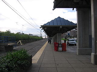
Florin station is a side platformed Sacramento RT light rail station in Sacramento, California, United States. The station was opened on September 26, 2003, and is operated by the Sacramento Regional Transit District. It is served by the Blue Line. The station is located north of Florin Road at Indian Lane, and serves the surrounding residential and commercial areas along Florin Road, the Department of Human Assistance, and Luther Burbank High School.

Meadowview station is a side platformed Sacramento RT light rail station in Sacramento, California, United States. The station was opened on September 26, 2003, and is operated by the Sacramento Regional Transit District. It is served by the Blue Line and was its southern terminus until 2015. With a daily average of 5,400 riders, the Meadowview station is the second busiest in the RT light rail system behind 16th Street station.
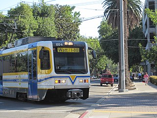
Watt/I-80 station is a below-grade light rail station on the Blue Line of the SacRT light rail system operated by the Sacramento Regional Transit District. The station is located in the median of Interstate 80 at its intersection of Watt Avenue, after which the station is named, in the community of North Highlands, California, United States.

Butterfield station is a side platformed SacRT light rail station in La Riviera, California, United States. The station was opened on September 5, 1987, and is operated by the Sacramento Regional Transit District. It is served by the Gold Line. The station is located at the intersection of Folsom Boulevard and Butterfield Way just northeast of Highway 50. From its opening through the opening of the Mather Field/Mills station on September 6, 1998, this served as the eastern terminus of the original RT light rail alignment.

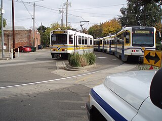
Sunrise station is a side-platformed SacRT light rail station in Rancho Cordova, California, United States. The station was opened on June 11, 2004, and is operated by the Sacramento Regional Transit District. It is served by the Gold Line. The station is located on Folsom Boulevard just south of Highway 50 at the intersection of Sunrise Boulevard.
13th Street station is a side platformed SacRT light rail station in Downtown Sacramento, California, United States. The station was opened on March 12, 1987, and is operated by the Sacramento Regional Transit District. All three RT light rail lines serve the station: Gold, Blue and Green, serving as the southern terminus for the Green Line. 13th Street station was the terminal for the light rail system from March 12, 1987, until September 5, 1987, when the line was extended to Butterfield.

St. Rose of Lima Park is a split SacRT light rail station, located near the park named in honor of Rose of Lima, in Downtown Sacramento, California. The northbound platform is located at the intersection of 9th & K Streets, and the former southbound platform was located at 7th & K Streets. When RT expanded the light rail system in 2007 to serve Sacramento Valley Station, it added 8th & K station in the block between the stations.
The Blue Line is a light rail line in the Sacramento Regional Transit District (RT) system. It runs primarily north–south in Sacramento between Watt/I-80 and Cosumnes River College. Along the route, the Blue Line serves North Highlands, North Sacramento, Downtown and South Sacramento. Portions of the Blue Line run along the original initial alignment between Watt/I-80 and 16th Street stations.

The Gold Line is a light rail transit line in the Sacramento Regional Transit District (RT) light rail system. Operating between Sacramento Valley and Historic Folsom stations, the line runs primarily east-west in Sacramento, portions of unincorporated Sacramento County, Rancho Cordova, Gold River and Folsom. Segments of the Gold Line run along the system's original alignment between 16th Street and Butterfield stations, which opened for service in 1987. The line has run in its modern configuration since June 2005, with extensions completed since then to Folsom and the downtown Amtrak station.

The Green Line is a light rail transit line in the Sacramento Regional Transit District (SacRT) light rail system. It opened on June 15, 2012, and runs between 13th Street station and 7th & Richards/Township 9 station. The Green Line runs through north downtown to Township 9 in the River District, and is projected eventually to reach Sacramento International Airport. The line only operates on weekdays.
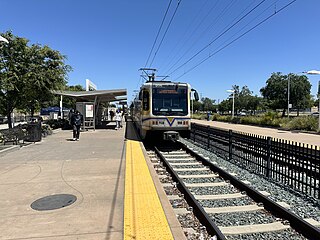
Cosumnes River College station is a side platformed Sacramento RT light rail station in Sacramento, California, United States. The station was opened on August 24, 2015, and is operated by the Sacramento Regional Transit District. It serves as the southern terminus of the Blue Line. The station is located on the east side of Cosumnes River College, near the intersection of Bruceville Road and Cosumnes River Boulevard in South Sacramento. It is attached to a 2,016-stall paid parking garage and is served by several bus routes at a dedicated bus station to the west of the platforms.

Franklin station is a side platformed Sacramento RT light rail station in Sacramento, California, United States. The station was opened on August 24, 2015, and is operated by the Sacramento Regional Transit District. It is served by the Blue Line. The station is located on the north side of Cosumnes River Boulevard west of Franklin Boulevard in the South Sacramento neighborhood of Valley Hi. There is a 668-stall park and ride with a daily fee located at the station.

Morrison Creek station is a side platformed SacRT light rail station in Sacramento, California, United States. The station was opened on August 29, 2021, and is operated by the Sacramento Regional Transit District. It is served by the Blue Line. The station is adjacent to Morrison Creek, for which the station is named.

The SacRT light rail system serves the Sacramento, California area. It is operated by the Sacramento Regional Transit District (SacRT) and has 42.9 miles (69.0 km) of network comprising three main lines on standard gauge tracks, 53 stations, and a fleet of 121 vehicles. With an average of 21,700 weekday daily boardings as of the second quarter of 2024, the SacRT light rail system is the fifteenth busiest in the United States.

Transportation in the Sacramento metropolitan area consists of a variety of modes of travel in El Dorado County, Placer County, Sacramento County, and Yolo County, which are the four counties that comprise the Sacramento metropolitan area.
