The Guiana Shield is one of the three cratons of the South American Plate. It is a 1.7 billion-year-old Precambrian geological formation in northeast South America that forms a portion of the northern coast. The higher elevations on the shield are called the Guiana Highlands, which is where the table-like mountains called tepuis are found. The Guiana Highlands are also the source of some of the world's most well-known waterfalls such as Angel Falls, Kaieteur Falls and Cuquenan Falls.

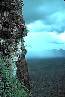
A tepui, or tepuy, is a table-top mountain or mesa found in South America, especially in Venezuela and western Guyana. The word tepui means "house of the gods" in the native tongue of the Pemon, the indigenous people who inhabit the Gran Sabana.

Canaima National Park is a 30,000 km2 (12,000 sq mi) park in south-eastern Venezuela that roughly occupies the same area as the Gran Sabana region. It is located in Bolívar State, reaching the borders with Brazil and Guyana. The park was named a World Heritage Site by UNESCO.
La Gran Sabana is a region in southeastern Venezuela, part of the Guianan savanna ecoregion.

The Guayana Region is an administrative region of eastern Venezuela.
Cerro Sarisariñama is a tepui, a flat-topped mountain in Jaua-Sarisariñama National Park at the far south-west of Bolívar State, Venezuela, near the border with Brazil. Its altitude range is between 300 m (980 ft) and 2,350 m (7,710 ft). The name of the mountain originates from the tale of local Ye'kuana Indians about an evil spirit living in caves up in the mountain and devouring human flesh with a sound "Sari... sari...".

Anomaloglossus wothuja is a species of frog in the family Aromobatidae. It is endemic to Venezuela and is only known from its type locality, the base of Cerro Sipapo, in the Amazonas state. It appears to be endemic to the Cerro Cuao massif but might occur more widely in similar granitic areas.
Pristimantis cantitans is a species of frog in the family Strabomantidae. It is endemic to Venezuela and only known from its type locality, the summit of Cerro Yaví, a sandstone table-top mountain (tepui) in the Amazonas State. The specific name cantitans alludes to the day-and-night calling behavior of this species and is derived from the Latin cantito.
Pristimantis pruinatus is a species of frog in the family Strabomantidae. It is endemic to Venezuela and only known from its type locality, the summit of Cerro Yaví, a sandstone table-top mountain (tepui) in the Amazonas State. The specific name pruinatus refers to the frosted appearance of this frog when alive and is derived from the Latin pruina (="frost") and -atus.

Stefania breweri, also known as Brewer's carrying frog, is a species of frog in the family Hemiphractidae. It is endemic to Cerro Autana, Venezuela, and only known from a single specimen (holotype). It was named for Venezuelan explorer Charles Brewer-Carías.
Cerro Marahuaca, also spelled Marahuaka, is a tepui in Amazonas state, Venezuela. It has an elevation of 2,832 metres (9,291 ft) above sea level and is the second-highest mountain of the entire Guayana Shield. Cerro Marahuaca shares a common base with the much larger Cerro Duida and together they form the Duida–Marahuaca Massif. Both tepuis are located entirely within the bounds of Duida–Marahuaca National Park.
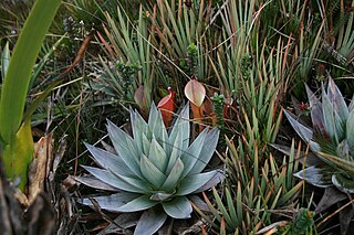
The natural range of the carnivorous plant genus Heliamphora is restricted to the southern Venezuelan states of Amazonas and Bolívar, and to adjacent portions of northern Brazil and western Guyana, an area corresponding to the western part of the Guayana Shield. These plants are largely confined to the summits and foothills of the sandstone table-top mountains of the region, known as tepuis.
Cerro Duida, named Yennamadi by the ye'kwana, is a very large tepui in Amazonas state, Venezuela. It has an uneven and heavily inclined plateau, rising from highs of around 1,300–1,400 metres (4,300–4,600 ft) in the north and east to a maximum of 2,358 metres (7,736 ft) on its southwestern rim. It has a summit area of 1,089 km2 (420 sq mi) and an estimated slope area of 715 km2 (276 sq mi). At its foot lies the small settlement of La Esmeralda, from which the mountain can be climbed.
The Chimantá Massif is a highly fragmented complex of tepuis in Bolívar state, Venezuela. The massif comprises around 11 tepuis and has a total summit area of 615 km2 (237 sq mi) and an estimated slope area of 915 km2 (353 sq mi). It is divided in two by the Río Tírica, with the northern section being both larger and higher. The massif is notable for its high species richness and for its varied habitat types. It reaches an elevation of 2,698 metres (8,852 ft) on its highest peak, Murey-tepui. The massif is situated entirely within the bounds of Canaima National Park. It hosts extensive cave systems, including the world's largest known quartzite cave, Cueva Charles Brewer, named after discoverer Charles Brewer-Carías. The processes behind their speleogenesis are the subject of some debate.

Ptari-tepui, also spelled Pu-tari and sometimes called Cerro Budare or Cerro del Budare, is a tepui in Bolívar state, Venezuela. Lying near the centre of the Sierra de Lema, it has a maximum elevation of around 2,400 metres (7,900 ft) above sea level. Its mostly bare summit plateau has an area of 1.25 km2 (0.48 sq mi). Though generally flat, distinctive erosional rock formations are found on the more dissected eastern edge of the summit.
The Sierra de Lema is an upland mountain range area with tepuis, located in Bolívar state of southeastern Venezuela.

Lago Leopoldo is a body of water located in the Venezuelan Amazon in the westernmost range of the Guiana Shield. It measures about 320 metres (1,050 ft) by and 240 metres (790 ft) and up to 20 metres (66 ft) deep. The water level was documented at 384 metres (1,260 ft) above sea level but may have diminished in recent years. Its name derives from the expedition that King Leopold III of Belgium made in 1952 which motored up the Sipapo, Autana and Umaj-Ajé rivers and set camp several miles from the lake. There is no firm evidence that members of King Leopold expedition actually reached the lake. Lago Leopoldo was first seen from the air as a landmark near the Cerro Autana tepui during the 1950s. The lake was first visited by helicopter in March 1973 by the Spanish naturalist Félix Rodríguez de la Fuente. The following April, the terrestrial route from the original King Leopold III camp was established by a Venezuelan expedition which reached the shores of the lake on April 18, 1973. Lago Leopoldo figures prominently in the oral history and lore of the native Piaroans where it is referred as "Paraka-Wachoe" or the lake in the mountains. Lago Leopoldo now renamed Lago Autana has been included as a natural monument within a protected area which includes the Cerro Autana and adjacent lands.

The Guayana natural region also simply known as Guayana in Venezuela, is a large massif of approximately 441,726 km2 (170,551 sq mi) area, equivalent to 48.2% of the total continental territory of the country.

The Formaciones de Tepuyes Natural Monument also known as tepui Also Formaciones de Tepuyes Is a protected natural space since 1991, located in Venezuela more specifically in the states of Amazonas and Bolívar. Should not be confused with the Canaima national park that contains part of the tepuyes.
Ceuthomantis aracamuni, also known as the Cerro Aracamuni emerald-barred frog, is a species of frog in the family Ceuthomantidae. It is endemic to Cerro Aracamuni in southern Amazonas, Venezuela.