
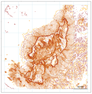
Auyán Tepui, also spelled Ayan, is a tepui in Bolívar state, Venezuela. It is the most visited and one of the largest tepuis in the Guiana Highlands, with a summit area of 666.9 km2 (257.5 sq mi) and an estimated slope area of 715 km2 (276 sq mi). The uneven, heart-shaped summit plateau of Auyán-tepui is heavily inclined, rising from around 1,600 metres (5,200 ft) in the northwest to a maximum of 2,450 m (8,040 ft) in the southeast. It is incised from the north by a vast valley, the Cañón del Diablo, formed by the Churún River. The larger western portion of the plateau is partially forested, whereas the eastern part comprises mostly bare rock with only patchy vegetation cover. The mountain hosts a number of extensive cave systems.
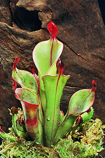
The genus Heliamphora contains 23 species of pitcher plants endemic to South America. The species are collectively known as sun pitchers, based on the mistaken notion that the heli of Heliamphora is from the Greek helios, meaning "sun". In fact, the name derives from helos, meaning marsh, so a more accurate translation of their scientific name would be marsh pitcher plants. Species in the genus Heliamphora are carnivorous plants that consist of a modified leaf form that is fused into a tubular shape. They have evolved mechanisms to attract, trap, and kill insects; and control the amount of water in the pitcher. At least one species produces its own proteolytic enzymes that allows it to digest its prey without the help of symbiotic bacteria.

Pico da Neblina is the highest peak in Brazil, 2,995.3 metres (9,827 ft) above sea level, in the Serra da Neblina, part of the Serra do Imeri, a section of the Guiana Highlands on the Brazil–Venezuela border. As determined by a border survey expedition in 1962, its summit lies just within Brazilian territory, at a horizontal distance of only 687 m (2,254 ft) from the Venezuelan border at Pico 31 de Março.

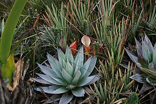
Abolboda is a genus of flowering plants, traditionally and nowadays assigned to family Xyridaceae. It is native to South America and to the island of Trinidad, generally on marshy savanna.
- Abolboda abbreviataMalme - Pará in Brazil
- Abolboda acaulisMaguire - Venezuela, Guyana
- Abolboda acicularisIdrobo & L.B.Sm. - Venezuela, Colombia
- Abolboda americana(Aubl.) Lanj. - Trinidad & Tobago, Colombia, Venezuela, the Guianas, northern Brazil
- Abolboda bellaMaguire - Cerro Yapacana in Venezuela
- Abolboda ciliataMaguire & Wurdack - Sierra de la Neblina in Venezuela
- Abolboda dunstervilleiMaguire ex Kral - Cerro Avispa in Venezuela
- Abolboda ebracteataMaguire & Wurdack - Venezuela, Colombia
- Abolboda egleriL.B.Sm. & Downs - Venezuela, Colombia, Pará
- Abolboda × glomerataMaguire - Venezuela (A. linearifolia × A. macrostachya)
- Abolboda grandisGriseb. - Venezuela, Colombia, Guyana, Suriname, northwestern Brazil
- Abolboda granularis(Maguire) L.M.Campb. & Kral - Venezuela, Colombia
- Abolboda killipiiLasser - Venezuela, Guyana, Suriname, northwestern Brazil
- Abolboda linearifoliaMaguire - State of Amazonas in southern Venezuela
- Abolboda macrostachyaSpruce ex Malme - Venezuela, Guyana, Suriname, Brazil
- Abolboda neblinaeMaguire - Sierra de la Neblina in Venezuela, northwestern Brazil
- Abolboda paniculataMaguire - Venezuela, northwestern Brazil
- Abolboda poarchonSeub. - Brazil, Paraguay
- Abolboda pulchellaHumb. & Bonpl. - Venezuela, Colombia, the Guianas, Brazil
- Abolboda scabridaKral - Cerro Aracamuni in Venezuela
- Abolboda spruceiMalme - Colombia, State of Amazonas in southern Venezuela
- Abolboda unifloraMaguire - Cerro Duida in Venezuela

Heliamphora neblinae is a species of marsh pitcher plant endemic to Cerro de la Neblina, Cerro Aracamuni and Cerro Avispa in Venezuela. It is one of the most variable species in the genus and was once considered to be a variety of H. tatei. It is unclear whether or not there is a consensus regarding its status as a species, with at least a few researchers supporting the taxonomic revision that would elevate both H. tatei var. neblinae and H. tatei f. macdonaldae to full species status.

Heliamphora tatei is a species of marsh pitcher plant endemic to Cerro Duida, Cerro Huachamacari and Cerro Marahuaca in Venezuela. It is closely related to H. macdonaldae, H. neblinae, and H. parva, and all three have in the past been considered forms or varieties of H. tatei. Like H. tatei, these species are noted for their stem-forming growth habit.
"Cochranella" riveroi is a species of frog in the family Centrolenidae. Its local name is ranita de cristal de Rivero. It is endemic to Cerro Aracamuni, Venezuela. The generic placement of this species within the subfamily Centroleninae is uncertain.

Cerro Marahuaca, also spelled Marahuaka, is a tepui in Amazonas state, Venezuela. It has an elevation of 2,832 metres (9,291 ft) above sea level and is the second-highest mountain of the entire Guayana Shield. Cerro Marahuaca shares a common base with the much larger Cerro Duida and together they form the Duida–Marahuaca Massif. Both tepuis are located entirely within the bounds of Duida–Marahuaca National Park.
Cerro de la Neblina, also known as Serra da Neblina in Brazil and Sierra de la Neblina in Venezuela, is a sandstone massif located in the northern Amazon Basin. It is a tilted, heavily eroded plateau, with a deep canyon in its central portion, drained by the Baria River.
The natural range of the carnivorous plant genus Heliamphora is restricted to the southern Venezuelan states of Amazonas and Bolívar, and to adjacent portions of northern Brazil and western Guyana, an area corresponding to the western part of the Guayana Shield. These plants are largely confined to the summits and foothills of the sandstone table-top mountains of the region, known as tepuis.
Cerro Duida, also known as Cerro Yennamadi, is a very large tepui in Amazonas state, Venezuela. It has an uneven and heavily inclined plateau, rising from highs of around 1,300–1,400 metres (4,300–4,600 ft) in the north and east to a maximum of 2,358 metres (7,736 ft) on its southwestern rim. It has a summit area of 1,089 km2 (420 sq mi) and an estimated slope area of 715 km2 (276 sq mi). At its foot lies the small settlement of La Esmeralda, from which the mountain can be climbed.
Cerro Huachamacari, also spelled Huachamakari or Kushamakari, is a tepui in Amazonas state, Venezuela. It lies northwest of the giant Cerro Duida and the other peaks of the Duida–Marahuaca Massif, and is considerably lower at only around 1,900 metres (6,200 ft).
Araopán-tepui is a tepui in Bolívar state, Venezuela. It has an elevation of around 2,450 metres (8,040 ft) above sea level. Together with the larger Aprada-tepui to the west, it forms part of the Aprada Massif. A steep, semi-circular ridge connects these two summits.
Cerro La Luna is a small tepui in Bolívar state, Venezuela. It is situated off the northern flank of Auyán-tepui, just southeast of the similarly small Cerro El Sol, and forms part of the Auyán Massif. Both it and Cerro El Sol emerge near the end of a long forested ridge leading from Auyán-tepui. Cerro La Luna has an elevation of around 1,650 metres (5,410 ft) and a summit area of 0.2 km2 (0.077 sq mi).
Cerro El Sol, also known as Wei- or Uei-tepui, is a small tepui in Bolívar state, Venezuela. It is situated off the northern flank of Auyán-tepui, just northwest of the similarly small Cerro La Luna, and forms part of the Auyán Massif. Both it and Cerro La Luna emerge near the end of a long forested ridge leading from Auyán-tepui. Cerro El Sol has an elevation of around 1,750 metres (5,740 ft) and a summit area of 0.6 km2 (0.23 sq mi).

Uei-tepui, also known as Wei-tepui, Cerro El Sol or Serra do Sol is a tepui on the border between Brazil and Venezuela. It may be considered the southernmost member of the Eastern Tepuis chain.
Aparamán-tepui is the westernmost of the four main tepuis of the Los Testigos chain in Bolívar, Venezuela. While the other three tepuis share a common slope area, Aparamán is derived from a separate basement. Aparamán-tepui has an elevation of around 2,100 metres (6,900 ft), a summit area of 1.25 km2 (0.48 sq mi), and an estimated slope area of 28 km2 (11 sq mi). Its mostly bare summit plateau is highly dissected, presenting difficulties even for helicopter landings.
Uaipán-tepui, also spelled Waipán, is a tepui in Bolívar state, Venezuela. It is a southern satellite peak of the vast Auyán Massif, with a maximum elevation of around 1,950 metres (6,400 ft). Its mostly forested summit plateau has an area of 2.5 km2 (0.97 sq mi). The mountain's slope area has been estimated at 60 km2 (23 sq mi).

Ptari-tepui, also spelled Pu-tari and sometimes called Cerro Budare or Cerro del Budare, is a tepui in Bolívar state, Venezuela. Lying near the centre of the Sierra de Lema, it has a maximum elevation of around 2,400 metres (7,900 ft) above sea level. Its mostly bare summit plateau has an area of 1.25 km2 (0.48 sq mi). Though generally flat, distinctive erosional rock formations are found on the more dissected eastern edge of the summit.


