Murisipán-tepui

Last updated
Murisipán-tepui
Venezuela relief location map (+claimed).jpg
Red triangle with thick white border.svg
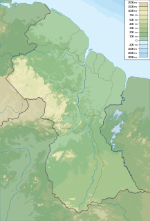
Murisipán-tepui
Location in Venezuela
Highest point
Elevation 2,350 m (7,710 ft) [1]
Coordinates 05°52′11″N62°04′32″W / 5.86972°N 62.07556°W / 5.86972; -62.07556 Coordinates: 05°52′11″N62°04′32″W / 5.86972°N 62.07556°W / 5.86972; -62.07556
Geography
Location Bolívar, Venezuela

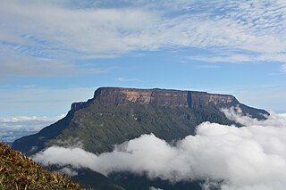
Murisipán-tepui, also spelled Murosipán or Murochiopán, is one of the four main tepuis of the Los Testigos chain in Bolívar, Venezuela. [1] Looking west to east, it is the second major peak of the massif and is connected to the next two—Tereke-yurén-tepui and Kamarkawarai-tepui—by a common basement (the westernmost peak, Aparamán-tepui, is relatively isolated by comparison). Murisipán-tepui has an elevation of around 2,350 metres (7,700 ft) and a summit area of 5 km2 (1.9 sq mi). The mountain's mostly bare summit plateau has a small, seasonal lagoon near its centre. [1]

Tepui A table-top mountain or mesa in the Guiana Highlands of South America

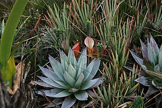
A tepui, or tepuy, is a table-top mountain or mesa found in the Guiana Highlands of South America, especially in Venezuela and western Guyana. The word tepui means "house of the gods" in the native tongue of the Pemon, the indigenous people who inhabit the Gran Sabana.

Los Testigos

Los Testigos, also known as the Aparamán range, is a mountain chain in Bolívar, Venezuela. It consists of four rather small tepuis, forming a bridge between the giant Auyán-tepui to the west and Ptari-tepui to the east. The four major peaks of Los Testigos are : Aparamán-tepui (2,100 m), Murisipán-tepui (2,350 m), Tereke-yurén-tepui (1,900 m), and Kamarkawarai-tepui (2,400 m), the latter three sharing a common slope area. There however remains some confusion in the literature regarding the names of these peaks.

Venezuela Republic in northern South America

Venezuela, officially the Bolivarian Republic of Venezuela, is a country on the northern coast of South America, consisting of a continental landmass and a large number of small islands and islets in the Caribbean Sea. The capital and largest urban agglomeration is the city of Caracas. It has a territorial extension of 916,445 km2. The continental territory is bordered on the north by the Caribbean Sea and the Atlantic Ocean, on the west by Colombia, Brazil on the south, Trinidad and Tobago to the north-east and on the east by Guyana. With this last country, the Venezuelan government maintains a claim for Guayana Esequiba over an area of 159,542 km2. For its maritime areas, it exercises sovereignty over 71,295 km2 of territorial waters, 22,224 km2 in its contiguous zone, 471,507 km2 of the Caribbean Sea and the Atlantic Ocean under the concept of exclusive economic zone, and 99,889 km2 of continental shelf. This marine area borders those of 13 states. The country has extremely high biodiversity and is ranked seventh in the world's list of nations with the most number of species. There are habitats ranging from the Andes Mountains in the west to the Amazon basin rain-forest in the south via extensive llanos plains, the Caribbean coast and the Orinoco River Delta in the east.

In his 1978 book, La Vegetación del Mundo Perdido, Charles Brewer-Carías applied the name Murochiopán-tepui to a smaller lateral peak of Aparamán-tepui ( 05°52′32″N62°06′48″W / 5.87556°N 62.11333°W / 5.87556; -62.11333 (lateral mountain of Aparamán Tepui) ), calling the high summit immediately east of it Tereke Yurén-tepui and the tiny peak east of that, Tucuy-wo-cuyén-tepui. Subsequent authors have generally used Murisipán-tepui (or its variants) for the second of the four main peaks, and Tereke-yurén-tepui for the third, with the lateral mountain of Aparamán-tepui going unnamed. [1]

Charles Brewer-Carías is a Venezuelan explorer and naturalist. Known as the "Humboldt of the twentieth century", Brewer-Carías has led more than 200 expeditions to remote parts of the Venezuelan Guayana, particularly the tepuis of the region. His discoveries include the sink holes of Cerro Sarisariñama and the world's largest known quartzite cave, Cueva Charles Brewer.

Tereke-yurén-tepui mountain in Venezuela

Tereke-yurén-tepui is one of the four main tepuis of the Los Testigos chain in Bolívar, Venezuela. Looking west to east, it is the third major peak of the massif and is connected to Murisipán-tepui and Kamarkawarai-tepui by a common basement. With a summit area of 0.63 km2 (0.24 sq mi) and an elevation of around 1,900 metres (6,200 ft), Tereke-yurén-tepui is both the smallest and lowest of the four peaks. Its summit plateau comprises mostly bare rock.

The frog species Anomaloglossus murisipanensis is only known from Murisipán-tepui. [2]

Anomaloglossus murisipanensis is a species of frog in the Aromobatidae family. It is endemic to Venezuela where it is known from its type locality, the Murisipán-tepui in the Bolívar state. It is known from only one specimen collected under a rock in tropical montane forest.

See also

Related Research Articles

Auyán-tepui mountain

Auyán Tepui, also spelled Ayan, is a tepui in Bolívar state, Venezuela. It is the most visited and one of the largest tepuis in the Guiana Highlands, with a summit area of 666.9 km2 (257.5 sq mi) and an estimated slope area of 715 km2 (276 sq mi). The uneven, heart-shaped summit plateau of Auyán-tepui is heavily inclined, rising from around 1,600 metres (5,200 ft) in the northwest to a maximum of 2,450 m (8,040 ft) in the southeast. It is incised from the north by a vast valley, the Cañón del Diablo, formed by the Churún River. The larger western portion of the plateau is partially forested, whereas the eastern part comprises mostly bare rock with only patchy vegetation cover. The mountain hosts a number of extensive cave systems.

Anomaloglossus breweri is a species of frogs in the Aromobatidae family. It is only know from its type locality, Aprada-tepui in the Bolívar state of southeastern Venezuela. This species was discovered by scientists exploring the inaccessible and remote region of Aprada-tepui. The distinctive features of this species are its particular skin pattern, absence of fringes on fingers, moderate toe webbing, tongue characteristics and yellow and orange coloration on its undersides. It is a fast-moving frog that lives along creeks and in quiet pools along small streams along the slopes near the cave. The frog is named for Charles Brewer-Carías who collected the frog.

<i>Heliamphora folliculata</i> species of plant

Heliamphora folliculata is a species of Marsh Pitcher Plant endemic to the Aparaman group of tepuis in Venezuela. It grows on all four mountains: Aparaman Tepui, Murosipan Tepui, Tereke Tepui and Kamakeiwaran Tepui.

Anomaloglossus praderioi is a species of frog in the Aromobatidae family. It is found in the Pantepui region of southeastern Venezuela and western Guyana. More specifically, this frog is known from Mount Roraima, Sierra de Lema in Venezuela, and Maringma-tepui in Guyana.

<i>Anomaloglossus tamacuarensis</i> species of amphibian

Anomaloglossus tamacuarensis is a species of frog in the family Aromobatidae. It is found in the Sierra Tapirapecó in the Amazonas state of Venezuela as well as in the adjacent Amazonas state of Brazil.

Anomaloglossus tepuyensis is a species of frog in the family Aromobatidae. It is found in southeastern Venezuela and western Guyana.

<i>Anomaloglossus rufulus</i> species of amphibian

Anomaloglossus rufulus is a species of frog in the Aromobatidae family. It is endemic to Venezuela where it is known from a few tepuis in the Chimantá Massif in the Bolívar state.

Cerro Marahuaca mountain

Cerro Marahuaca, also spelled Marahuaka, is a tepui in Amazonas state, Venezuela. It has an elevation of 2,832 metres (9,291 ft) above sea level and is the second-highest mountain of the entire Guayana Shield. Cerro Marahuaca shares a common base with the much larger Cerro Duida and together they form the Duida–Marahuaca Massif. Both tepuis are located entirely within the bounds of Duida–Marahuaca National Park.

Upuigma-tepui mountain in Venezuela

Upuigma-tepui, also known as El Castillo, is a tepui in Bolívar state, Venezuela. A relatively isolated peak, both it and nearby Angasima-tepui lie just south of the vast Chimantá Massif, from which they are separated by the Río Aparurén valley. Upuigma-tepui is situated entirely within the bounds of Canaima National Park.

Distribution of <i>Heliamphora</i>

The natural range of the carnivorous plant genus Heliamphora is restricted to the southern Venezuelan states of Amazonas and Bolívar, and to adjacent portions of northern Brazil and western Guyana, an area corresponding to the western part of the Guayana Shield. These plants are largely confined to the summits and foothills of the sandstone table-top mountains of the region, known as tepuis.

Chimantá Massif

The Chimantá Massif is a highly fragmented complex of tepuis in Bolívar state, Venezuela. The massif comprises around 11 tepuis and has a total summit area of 615 km2 (237 sq mi) and an estimated slope area of 915 km2 (353 sq mi). It is divided in two by the Río Tírica, with the northern section being both larger and higher. The massif is notable for its high species richness and for its varied habitat types. It reaches an elevation of 2,698 metres (8,852 ft) on its highest peak, Murey-tepui. The massif is situated entirely within the bounds of Canaima National Park. It hosts extensive cave systems, including the world's largest known quartzite cave, Cueva Charles Brewer, named after discoverer Charles Brewer-Carías. The processes behind their speleogenesis are the subject of some debate.

Kamarkawarai-tepui mountain in Venezuela

Kamarkawarai-tepui, also spelled Kamarkaiwaran or Camarcai-barai, is the easternmost and tallest of the four main tepuis of the Los Testigos chain in Bolívar, Venezuela. It is connected to the two nearest peaks of the massif—Murisipán-tepui and Tereke-yurén-tepui—by a common basement. The mostly bare summit plateau of Kamarkawarai-tepui has a large, collapsed sinkhole opening in its western portion.

Aparamán-tepui mountain in Venezuela

Aparamán-tepui is the westernmost of the four main tepuis of the Los Testigos chain in Bolívar, Venezuela. While the other three tepuis share a common slope area, Aparamán is derived from a separate basement. Aparamán-tepui has an elevation of around 2,100 metres (6,900 ft), a summit area of 1.25 km2 (0.48 sq mi), and an estimated slope area of 28 km2 (11 sq mi). Its mostly bare summit plateau is highly dissected, presenting difficulties even for helicopter landings.

Angasima-tepui mountain in Venezuela

Angasima-tepui, also known as Adanta, Adankasima or Adankachimö, is a tepui in Bolívar state, Venezuela. A relatively isolated peak, both it and nearby Upuigma-tepui lie just south of the vast Chimantá Massif, from which they are separated by the Río Aparurén valley. Amurí-tepui, the closest member of the Chimantá Massif, is only 8 kilometres (5.0 mi) from Angasima-tepui.

Eastern Tepuis

The Eastern Tepuis, also known as the Roraima–Ilú range, is a mountain chain stretching for some 60 kilometres (37 mi) along the border between the disputed territory of Guayana Esequiba in Guyana, Venezuela and, to a small extent, Brazil. It runs in a northwesterly direction from the tripoint of these countries, closely following the Guyana–Venezuela border, with a single major peak (Uei-tepui) to the south, on the Brazil–Venezuela border. Moving northwest from Uei-tepui (2,150 m), the main summits of this chain are Roraima-tepui (2,810 m), Kukenán-tepui (2,650 m), Yuruaní-tepui (2,400 m), Wadakapiapué-tepui (2,000 m), Karaurín-tepui (2,500 ), Ilú-tepui (2,700 m), and Tramen-tepui. The minor peak of Wei-Assipu-tepui lies entirely outside Venezuela, on the border between Brazil and Guyana. Additionally, there are a number of minor plateaus which form a chain between Uei-tepui and Roraima-tepui. Ilú- and Tramen-tepuis are often treated together since they are joined by a common base.

Ilú–Tramen Massif mountain in Venezuela

The Ilú–Tramen Massif is a tepui massif in Bolívar state, Venezuela. It is the northernmost member of the Eastern Tepuis chain and comprises two major plateaus: the larger Ilú-tepui to the south and Tramen-tepui to the north. With a maximum elevation of around 2,700 metres (8,900 ft), Ilú-tepui is the taller of the two peaks. Both tepuis have open, rocky summit plateaus, with a combined summit area of 5.63 km2 (2.17 sq mi). They lie just north of Karaurín-tepui.

Maringma-tepui mountain in Guyana

Maringma-tepui, also written Mount Maringma and historically known as Mount Marima, is a small tepui of the Pacaraima Mountains in Cuyuni-Mazaruni, Guyana. It is known as Malaima-tepui in the local Akawaio language. Most published sources place it just inside Guyanese territory, very close to the border with Brazil, and around 17 kilometres (11 mi) east of Roraima-tepui. However, the mountain remains the subject of considerable toponymic confusion and its name has been applied to at least one other nearby peak.

References

  1. 1 2 3 4 Huber, O. (1995). Geographical and physical features. In: P.E. Berry, B.K. Holst & K. Yatskievych (eds.) Flora of the Venezuelan Guayana. Volume 1. Introduction. Missouri Botanical Garden Press, St. Louis. pp. 1–61.
  2. Frost, Darrel R. (2014). "Anomaloglossus murisipanensis (La Marca, 1997)". Amphibian Species of the World: an Online Reference. Version 6.0. American Museum of Natural History. Retrieved 15 June 2014.