
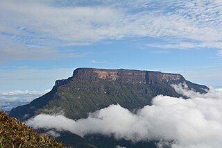
Auyán Tepui, also spelled Ayan, is a tepui in Bolívar state, Venezuela. It is the most visited and one of the largest tepuis in the Guiana Highlands, with a summit area of 666.9 km2 (257.5 sq mi) and an estimated slope area of 715 km2 (276 sq mi). The uneven, heart-shaped summit plateau of Auyán-tepui is heavily inclined, rising from around 1,600 metres (5,200 ft) in the northwest to a maximum of 2,450 m (8,040 ft) in the southeast. It is incised from the north by a vast valley, the Cañón del Diablo, formed by the Churún River. The larger western portion of the plateau is partially forested, whereas the eastern part comprises mostly bare rock with only patchy vegetation cover. The mountain hosts a number of extensive cave systems.
La Gran Sabana is a region in southeastern Venezuela, part of the Guianan savanna ecoregion.

Upuigma-tepui, also known as El Castillo, is a tepui in Bolívar state, Venezuela. A relatively isolated peak, both it and nearby Angasima-tepui lie just south of the vast Chimantá Massif, from which they are separated by the Río Aparurén valley. Upuigma-tepui is situated entirely within the bounds of Canaima National Park.
Heliamphora arenicola is a species of marsh pitcher plant known only from the western side of the Ilu–Tramen Massif in Venezuela's Gran Sabana, where it grows at elevations of less than 2000 m. It may also occur on Karaurin Tepui.
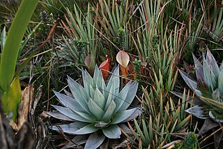
The natural range of the carnivorous plant genus Heliamphora is restricted to the southern Venezuelan states of Amazonas and Bolívar, and to adjacent portions of northern Brazil and western Guyana, an area corresponding to the western part of the Guayana Shield. These plants are largely confined to the summits and foothills of the sandstone table-top mountains of the region, known as tepuis.

Aprada-tepui is a tepui in Bolívar state, Venezuela. It has an elevation of around 2,500 metres (8,200 ft) above sea level. It gives its name to the Aprada Massif, which also includes the smaller Araopán-tepui to the east. A steep, semi-circular ridge connects these two summits. Aprada-tepui lies 22 kilometres (14 mi) northwest of the much larger Chimantá Massif and around 25 km (16 mi) east of the Pemón village of Urimán.

Araopán-tepui is a tepui in Bolívar state, Venezuela. It has an elevation of around 2,450 metres (8,040 ft) above sea level. Together with the larger Aprada-tepui to the west, it forms part of the Aprada Massif. A steep, semi-circular ridge connects these two summits.
Cerro El Sol, also known as Wei- or Uei-tepui, is a small tepui in Bolívar state, Venezuela. It is situated off the northern flank of Auyán-tepui, just northwest of the similarly small Cerro La Luna, and forms part of the Auyán Massif. Both it and Cerro La Luna emerge near the end of a long forested ridge leading from Auyán-tepui. Cerro El Sol has an elevation of around 1,750 metres (5,740 ft) and a summit area of 0.6 km2 (0.23 sq mi).

Uei-tepui, also known as Wei-tepui, Cerro El Sol or Serra do Sol is a tepui on the border between Brazil and Venezuela. It may be considered the southernmost member of the Eastern Tepuis chain.
Kamarkawarai-tepui, also spelled Kamarkaiwaran or Camarcai-barai, is the easternmost and tallest of the four main tepuis of the Los Testigos chain in Bolívar, Venezuela. It is connected to the two nearest peaks of the massif—Murisipán-tepui and Tereke-yurén-tepui—by a common basement. The mostly bare summit plateau of Kamarkawarai-tepui has a large, collapsed sinkhole opening in its western portion.
Aparamán-tepui is the westernmost of the four main tepuis of the Los Testigos chain in Bolívar, Venezuela. While the other three tepuis share a common slope area, Aparamán is derived from a separate basement. Aparamán-tepui has an elevation of around 2,100 metres (6,900 ft), a summit area of 1.25 km2 (0.48 sq mi), and an estimated slope area of 28 km2 (11 sq mi). Its mostly bare summit plateau is highly dissected, presenting difficulties even for helicopter landings.
Los Testigos, also known as the Aparamán range, is a mountain chain in Bolívar, Venezuela. It consists of four rather small tepuis, forming a bridge between the giant Auyán-tepui to the west and Ptari-tepui to the east. The four major peaks of Los Testigos are : Aparamán-tepui (2,100 m), Murisipán-tepui (2,350 m), Tereke-yurén-tepui (1,900 m), and Kamarkawarai-tepui (2,400 m), the latter three sharing a common slope area. There however remains some confusion in the literature regarding the names of these peaks.

Wadakapiapué-tepui, also spelled Wadakapiapö, Wadakapiapo, Wadaka Piapo or Guadacapiapui, is a tepui of the Eastern Tepuis chain in Bolívar, Venezuela. It has an elevation of around 2,000 metres (6,600 ft). Its tiny tower-like summit has an area of less than 0.01 km2 (0.0039 sq mi), making it the smallest member of the Eastern Tepuis. It lies just west of the much larger Yuruaní-tepui.

Yuruaní-tepui, also known by the Pemón name Iwalkarima, Iwalecalima or Iwarkárima, is a tepui of the Eastern Tepuis chain primarily situated in Venezuela, while part of the eastern ridge stretches into the disputed Guayana Esequiba territory in Guyana. It has an elevation of around 2,400 metres (7,900 ft), the high plateau being located entirely within Venezuela, and a summit area of 4.38 km2 (1.69 sq mi). It lies just east of the much smaller Wadakapiapué-tepui. This Tepui is not located in the Canaima National Park unlike most other Tepuis in the area.

Ptari-tepui, also spelled Pu-tari and sometimes called Cerro Budare or Cerro del Budare, is a tepui in Bolívar state, Venezuela. Lying near the centre of the Sierra de Lema, it has a maximum elevation of around 2,400 metres (7,900 ft) above sea level. Its mostly bare summit plateau has an area of 1.25 km2 (0.48 sq mi). Though generally flat, distinctive erosional rock formations are found on the more dissected eastern edge of the summit.
Sororopán-tepui is a 10-kilometre (6.2 mi) long ridge in Bolívar state, Venezuela. It has a maximum elevation of around 2,050 m (6,730 ft) and its densely forested slopes cover an estimated area of 30 km2 (12 sq mi). The ridge has a southwest–northeast orientation and is characterised by a steep southern face. Part of the Ptari Massif, it lies just south of Carrao-tepui and neighbouring Ptari-tepui.
Carrao-tepui, also spelled Karrao, is a tepui in Bolívar state, Venezuela. It has a maximum elevation of around 2,200 metres (7,200 ft) and its densely forested summit plateau covers an area of 1.25 km2 (0.48 sq mi). Part of the Ptari Massif, it lies just northeast of neighbouring Ptari-tepui, with which it shares a common slope area of 28 km2 (11 sq mi), and north of the large ridge known as Sororopán-tepui.
The Ilú–Tramen Massif is a tepui massif in Bolívar state, Venezuela. It is the northernmost member of the Eastern Tepuis chain and comprises two major plateaus: the larger Ilú-tepui to the south and Tramen-tepui to the north. With a maximum elevation of around 2,700 metres (8,900 ft), Ilú-tepui is the taller of the two peaks. Both tepuis have open, rocky summit plateaus, with a combined summit area of 5.63 km2 (2.17 sq mi). They lie just north of Karaurín-tepui.


