
Broughton Gifford is a village and civil parish about 1.5 miles (2.4 km) west of Melksham in Wiltshire, England. The parish includes the hamlets of Norrington Common and The Common.

Corsham is a historic market town and civil parish in west Wiltshire, England. It is at the southwestern edge of the Cotswolds, just off the A4 national route. It is 28 miles (45 km) southwest of Swindon, 20 miles (32 km) east of Bristol, 8 miles (13 km) north-east of Bath, and 4 miles (6 km) southwest of Chippenham.

Aldbourne is a village and civil parish about 6 miles (10 km) north-east of Marlborough, Wiltshire, England, in a valley on the south slope of the Lambourn Downs – part of the North Wessex Downs Area of Outstanding Natural Beauty. From here an unnamed winterbourne flows south to join the River Kennet 4 miles (6 km) away near Ramsbury. The 2011 Census recorded the parish population as 1,833. The parish includes the hamlets of Upper Upham and Woodsend and part of the hamlet of Preston, which straddles the boundary with Ramsbury. The village of Snap became deserted in the early 20th century.

Bishops Cannings is a village and civil parish in the Vale of Pewsey in Wiltshire, England, 3 miles (5 km) north-east of Devizes. The parish includes the village of Coate and the hamlets of Bourton, Horton and Little Horton.

Froxfield is a village and civil parish in the English county of Wiltshire. The parish is on the Wiltshire-West Berkshire border, and the village lies on the A4 national route about 2.5 miles (4 km) west of Hungerford and 7 miles (11 km) east of Marlborough.

Box is a large village and civil parish within the Cotswolds Area of Outstanding Natural Beauty in Wiltshire, England, about 3 miles (5 km) west of Corsham and 5 miles (8 km) northeast of Bath. Box also falls in the easternmost part of the Avon Green Belt. Besides the village of Box, the parish includes the villages of Ashley and Box Hill; Hazelbury manor; and the hamlets of Alcombe, Blue Vein, Chapel Plaister, Ditteridge, Henley, Kingsdown, Middlehill, and Wadswick. To the east the parish includes much of Rudloe, formerly a hamlet but now a housing estate, and the defence establishments and related businesses on the site of the former RAF Rudloe Manor.

Biddestone is a village and former civil parish, now in the parish of Biddestone and Slaughterford, in northwest Wiltshire, England, about 3 miles (5 km) west of Chippenham and 2 miles (3.2 km) north of Corsham. The parish includes the smaller settlement of Slaughterford.

Winterslow is a civil parish with a population of around 2,000, about 6 miles (10 km) northeast of Salisbury in Wiltshire, England, and lying south of the A30 London Road. It is sited on the Roman road between Old Sarum and Winchester.
Atworth is a village and civil parish in west Wiltshire, England. The village is on the A365 road between Melksham and Box, about 2.5 miles (4 km) northwest of Melksham and 4 miles (6 km) northeast of Bradford on Avon. The hamlet of Purlpit lies east of Atworth village, and in the south of the parish are the small village of Great Chalfield and the hamlet of Little Chalfield.
Berwick St John is a village and civil parish in southwest Wiltshire, England, about 5 miles (8 km) east of Shaftesbury in Dorset. The parish includes the Ashcombe Park estate, part of the Ferne Park estate, and most of Rushmore Park.
Lyneham is a large village in north Wiltshire, England, within the civil parish of Lyneham and Bradenstoke, and situated 4 miles (6.4 km) southwest of Royal Wootton Bassett, 5.5 miles (8.9 km) north of Calne and 11 miles (18 km) southwest of Swindon. The village is on the A3102 road between Calne and Wootton Bassett.

Monkton Farleigh is a village and civil parish in west Wiltshire, England, on high ground 3 miles (5 km) northwest of Bradford-on-Avon, and a similar distance east of the city of Bath. The parish includes the hamlets of Farleigh Wick and Pinckney Green. In the west and northwest the parish is bounded by Somerset.

Colerne is a village and civil parish in north Wiltshire, England. The village is about 3.5 miles (6 km) west of the town of Corsham and 7 miles (11 km) northeast of the city of Bath. It has an elevated and exposed position, 545 feet (166 m) above sea level, and overlooks the Box valley to the south.

Hilmarton is a village and civil parish in North Wiltshire, in the west of England. The village lies on the A3102 between the towns of Calne and Wootton Bassett, and 2 miles (3.2 km) south of Lyneham. The parish includes the village of Goatacre and the hamlets of Catcomb, Clevancy, Highway and New Zealand.

Upavon is a rural village and civil parish in the county of Wiltshire, England. As its name suggests, it is on the upper portion of the River Avon which runs from north to south through the village. It is on the north edge of Salisbury Plain about 4 miles (6.4 km) south of Pewsey, 10 miles (16 km) southeast of the market town of Devizes, and 20 miles (32 km) north of the cathedral city of Salisbury. The A345 and A342 roads run through the village.

Whitley is a village in the civil parish of Melksham Without, Wiltshire, England, which had a population of 1,914 at the 2011 census. The village lies about 2 miles (3.2 km) northwest of Melksham on the B3353 Shaw to Corsham road. The hamlet of West Hill is to the west, on the road to Atworth.

Hazelbury is a former village in the civil parish of Box, Wiltshire, England. It was about 0.5 miles (0.8 km) southeast of the present-day village of Box and 3 miles (5 km) south-west of the town of Corsham.

Ditteridge is a village in the civil parish of Box, Wiltshire, England. It is about 0.8 miles (1.3 km) northwest of Box village and 3.5 miles (6 km) west of the town of Corsham. Formerly a larger settlement, it has an early Norman church and had its own civil parish for a time in the 19th century.
South Wraxall is a village and a civil parish in Wiltshire, England, 2.5 miles (4.0 km) north of Bradford on Avon. The village is to the west of the B3109 road from Bradford on Avon to Corsham.

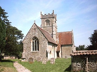
The Church of St. Thomas à Becket is the Church of England parish church of Box, Wiltshire, in south-west England. It is one of a number of churches named after Thomas Becket following his martyrdom. The church has 12th-century origins and was substantially remodelled in the 14th, 15th, 18th and 19th centuries. It is a Grade I listed building.

