Chazy is a town in northeastern Clinton County, New York, United States. The population was 4,284 at the 2010 census. The closest city is Plattsburgh, 14 miles (23 km) to the south. Chazy is 8 miles (13 km) south of the Canada–United States border. The ZIP code is 12921 and the community is in area code 518.

Altona is a town in Clinton County, New York, United States. The population was 2,887 at the 2010 census. The town was named after the Altona, Hamburg, district of Germany. The town contains a hamlet also called Altona.

Champlain is a town in Clinton County, New York, United States. The population was 5,754 at the 2010 census. The town is located on the western shore of Lake Champlain, near the northern end of Lake Champlain and is on the U.S./Canadian border.

Dannemora is a town in Clinton County, New York, United States. The population was 4,898 at the 2010 census. The town is named after Dannemora, Sweden, an important iron-mining region.

Mooers, formerly Mooers-upon-the-Chazy, is a hamlet and census-designated place in the town of Mooers, in Clinton County, New York, United States. The population was 442 at the 2010 census, out of a total population of 3,592 in the town. It was once an incorporated village, but dissolved in 1994.
Mooers is a town in Clinton County, New York, United States. The population was 3,592 at the 2010 census. The town is named after Benjamin Mooers, an early settler.
Lakeville is a hamlet and census-designated place (CDP) in the town of Livonia, Livingston County, New York, United States. Its population was 756 as of the 2010 census.
East Avon is a hamlet and census-designated place (CDP) in the town of Avon, Livingston County, New York, United States. The population was 608 at the 2010 census.

Freedom Plains is a hamlet and census-designated place (CDP) in Dutchess County, New York, United States. As of the 2010 census the population was 421.
Lime Lake is a hamlet and census-designated place (CDP) in the northeast part of the town of Machias, in Cattaraugus County, New York, United States. As of the 2010 census, it had a population of 867. Prior to the 2010 census, the area was delineated as part of the Lime Lake-Machias CDP.
Machias is a hamlet and census-designated place (CDP) in the northeast part of the town of Machias, in Cattaraugus County, New York, United States. As of the 2010 census, it had a population of 471. Prior to the 2010 census, the area was delineated as part of the Lime Lake-Machias CDP.
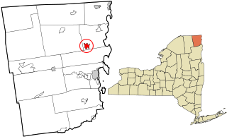
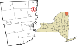
West Chazy is a hamlet and census-designated place in the town of Chazy in Clinton County, New York, United States. The population was 529 at the 2010 census.
Willsboro is a hamlet and census-designated place (CDP) in the town of Willsboro in Essex County, New York, United States. The population of the CDP was 753 at the 2010 census, out of a total town population of 2,025.
Wilmington is a hamlet and census-designated place (CDP) in the town of Wilmington in Essex County, New York, United States. The population of the CDP was 937 at the 2010 census, out of a total town population of 1,253.
Fort Covington is a census-designated place (CDP) within the town of Fort Covington, Franklin County, New York, United States. It consists of the hamlet of Fort Covington, as well as a large amount of rural land surrounding the hamlet, such that the CDP occupies about one half of the area within the town limits. The population of the CDP was 1,308 at the 2010 census, out of a total town population of 1,676.
Conesus Lake is a hamlet and census-designated place (CDP) in Livingston County, New York, United States. Its population was 2,584 as of the 2010 census. The community is located in the towns of Geneseo, Livonia, Groveland, and Conesus and covers Conesus Lake, the westernmost of New York's Finger Lakes, and nearly all of the lake's shoreline communities.
Greigsville is a hamlet and census-designated place (CDP) in the town of York, Livingston County, New York, United States. Its population was 209 as of the 2010 census. The community is located at the intersection of New York State Route 36 and New York State Route 63.
Groveland Station is a census-designated place (CDP) in Livingston County, New York, United States. The CDP consists of the hamlet of Groveland and nearby residential areas. The CDP population was 281 as of the 2010 census. New York State Route 63 passes through the community.
Kysorville is a hamlet and census-designated place (CDP) in the town of West Sparta, Livingston County, New York, United States. Its population was 110 as of the 2010 census.
Wadsworth is a hamlet and census-designated place (CDP) in the town of York, Livingston County, New York, United States. Its population was 190 as of the 2010 census. New York State Route 36 passes through the community.