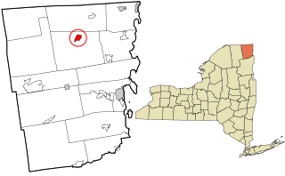
Clinton County is the northeastern most county in the northeastern corner of the state of New York, in the United States and bordered by the Canadian province of Quebec. As of the 2020 United States Census, the population was 79,843. Its county seat is the city of Plattsburgh. The county lies just south of the border with the Canadian province of Quebec and to the west of the State of Vermont. The county is named for George Clinton, the first Governor of New York, who later was elected as Vice President. He had been a Founding Father who represented New York in the Continental Congress. Clinton County comprises the Plattsburgh, New York Micropolitan statistical area. The county is part of the North Country region of the state.

Tillmans Corner, or Tillman’s Corner, is an unincorporated community and census-designated place (CDP) in Mobile County, Alabama, United States. At the 2020 census, the population was 17,731. It is part of the Mobile metropolitan area, and is the largest census-designated place in Alabama.

Clinton is an unincorporated community and census-designated place (CDP) in Missoula County, Montana, United States. It is part of the Missoula metropolitan area. The population was 1,018 at the 2020 census.

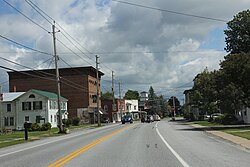
Chazy is a town in northeastern Clinton County, New York, United States. The population was 4,096 at the 2020 census. The closest city is Plattsburgh, 14 miles (23 km) to the south. Chazy is 8 miles (13 km) south of the Canada–United States border. The ZIP code is 12921 and the community is in area code 518.

Cumberland Head is a census-designated place and region of the town of Plattsburgh in Clinton County, New York, United States. The population was 1,627 at the 2010 census.

Lyon Mountain is a hamlet and census-designated place located in the town of Dannemora in Clinton County, New York, United States. The population was 423 at the 2010 census.

Morrisonville is a hamlet and census-designated place in Clinton County, New York, United States. The population was 1,545 at the 2010 census.

Parc is a location and census-designated place in Clinton County, New York, United States. The name "Parc" is derived from the official name for the 3,447-acre (13.95 km2) industrial site, which is PARC, an acronym for the Plattsburgh Airbase Redevelopment Corporation. PARC was established for the purpose of redeveloping the Plattsburgh Air Force Base after it closed on September 25, 1995. PARC is now operated by the Plattsburgh Air Base Development Authority, and the massive airfield is now Plattsburgh International Airport. The population of the Parc CDP was 254 at the 2010 census. Parc is located in the town of Plattsburgh and is bordered to the north by the city of Plattsburgh.

Plattsburgh West is a census-designated place (CDP) and region of the town of Plattsburgh in Clinton County, New York, United States. The population was 1,364 at the 2010 census. The CDP lies to the west of the city of Plattsburgh.

Redford is a hamlet and census-designated place in the town of Saranac in Clinton County, New York, United States. The population was 477 at the 2010 census.

Dunnstown is a census-designated place (CDP) in Clinton County, Pennsylvania, United States. The population was 1,360 at the 2010 census.

Elk Township is a township in Tioga County, Pennsylvania, United States. The population was 45 at the 2020 census, and 49 at the 2010 census. There were five children under the age of 19 years.

Clinton is a community and census-designated place (CDP) located on southern Whidbey Island in Island County, Washington, United States. The town was named after Clinton, Michigan. As of the 2010 census, the population was 928. However, the post office serves at least 2,500 people.
Altona is a hamlet and census-designated place (CDP) in the town of Altona, Clinton County, New York, United States. The population was 730 at the 2010 census, out of a total town population of 2,887.

Champlain is a village in Clinton County, New York, United States. The population was 1,101 at the 2010 census. The village is located in the town of Champlain, approximately 4 miles (6 km) west of Lake Champlain, and is north of Plattsburgh.

Champlain is a town in Clinton County, New York, United States. The population was 5,754 at the 2010 census. The town is located on the western shore of Lake Champlain, near the northern end of Lake Champlain and is on the U.S./Canadian border.

Dannemora is a town in Clinton County, New York, United States. The population was 4,037 at the 2020 census, down from 4,898 in 2010. The town is named after Dannemora, Sweden, an important iron-mining region.

Mooers is a town in Clinton County, New York, United States. The population was 3,592 at the 2010 census. The town is named after Benjamin Mooers, an early settler.

Peru is a hamlet and census-designated place (CDP) within the town of Peru in Clinton County in the U.S. state of New York. The population of the CDP was 1,591 at the 2010 census, out of a population of 6,998 in the town as a whole.

Clinton is a census-designated place (CDP) and the primary village in the town of Clinton in Kennebec County, Maine, United States. The population was 1,419 at the 2010 census, out of 3,486 in the entire town of Clinton.