Chesterfield, Tennessee | |
|---|---|
 Chesterfield  Chesterfield | |
| Coordinates: 35°38′04″N88°16′01″W / 35.63444°N 88.26694°W | |
| Country | United States |
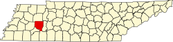
| State | Tennessee |
| County | Henderson |
| Area | |
• Total | 7.70 sq mi (19.93 km2) |
| • Land | 7.68 sq mi (19.90 km2) |
| • Water | 0.01 sq mi (0.04 km2) |
| Elevation | 404 ft (123 m) |
| Population | |
• Total | 543 |
| • Density | 70.68/sq mi (27.29/km2) |
| Time zone | UTC-6 (Central (CST)) |
| • Summer (DST) | UTC-5 (CDT) |
| ZIP code | 38351 [3] |
| Area code | 731 |
| GNIS feature ID | 1280369 [4] |
Chesterfield is a census-designated place and unincorporated community in Henderson County, Tennessee, United States. Its population was 469 as of the 2010 census. [5]