Chicklade

Last updated • 2 min readFrom Wikipedia, The Free Encyclopedia

Chicklade
All Saints, Chicklade - geograph.org.uk - 458184.jpg
All Saints' parish church
Wiltshire UK location map.svg
Red pog.svg
Chicklade
Location within Wiltshire
Population75 (2011 Census) [1]
OS grid reference ST911345
Civil parish
  • Chicklade
Unitary authority
Ceremonial county
Region
Country England
Sovereign state United Kingdom
Post town Salisbury
Postcode district SP3
Dialling code 01747
Police Wiltshire
Fire Dorset and Wiltshire
Ambulance South Western
UK Parliament
List of places
UK
England
Wiltshire
51°06′36″N2°07′37″W / 51.110°N 2.127°W / 51.110; -2.127

Chicklade is a small village and civil parish in Wiltshire, South West England. The village is on the A303 road, about 7 miles (11 km) south of Warminster. The parish includes the hamlet of Upper Pertwood.

Contents

The Great Ridge Wood, formerly also known as Chicklade Wood, is less than a mile north of the village, just over the parish boundary.

Etymology

The name Chicklade is first attested in a charter from between 901 and 924, as Cytlid, later forms including Chikelaď (1199), Ciclet (1210–12), Ciklet (1242), and Chikelade (1281). [2] Although the etymology of Chicklade is uncertain, its first syllable is agreed to originate in the Common Brittonic word that survives in modern Welsh as coed ("woodland"). [3] :340

History

John Marius Wilson's Imperial Gazetteer of England and Wales (1870–72) describes Chicklade as follows:

CHICKLADE, a parish in Tisbury district, Wilts; 1¼ mile N by E of Hindon, and 5 S by-W of Heytesbury r. station. Post town, Hindon, under Salisbury. Acres, 1,039. Real property, with Hindon, Berwick-St. Leonard, and Fonthill-Gifford, £5,111. Pop., 143. Houses, 23. The property is divided among a few. The surface is hilly. The living is a rectory in the diocese of Salisbury. Value, £230. Patron, the Marquis of Bath. The church is good. [4]

On 22 October 1963 the prototype BAC One-Eleven aircraft G-ASHG flown by Mike Lithgow entered a deep stall and crashed near Chicklade, killing all seven crew. (See 1963 BAC One-Eleven test crash)

Churches

The Church of England parish church of All Saints was built in 1832 to designs in 12th-century style by J.B. Papworth. It stands on the site of a 12th-century church. [5]

The poet William Lisle Bowles was Vicar of Chicklade 1792–97.

Pertwood also had a 12th-century church, St Peter's, which was rebuilt in 1872. The ecclesiastical parish of Pertwood was separate until 1899 when it was united with Chicklade, then in 1921, Chicklade with Pertwood was united with Hindon parish. The church at Pertwood was declared redundant in 1972. [6]

Parish registers for Chicklade survive from 1722 and are kept in the Wiltshire and Swindon Archives. [7]

Local government

The civil parish does not elect a parish council. Instead the first tier of local government is a parish meeting, which all electors are entitled to attend. [8] The parish is in the area of Wiltshire Council unitary authority, which is responsible for all significant local government functions.

Related Research Articles

<span class="mw-page-title-main">Bromham, Wiltshire</span> Village in Wiltshire, England

Bromham is a village and civil parish in Wiltshire, England. The village is 3+12 miles (6 km) northwest of Devizes and the same distance east of Melksham.

<span class="mw-page-title-main">Cherhill</span> Village and civil parish in Wiltshire, England

Cherhill is a village and civil parish in Wiltshire, England. The village is about 2+12 miles (4 km) east of the town of Calne, on the A4 road towards Marlborough. The parish includes the village of Yatesbury.

<span class="mw-page-title-main">Ludgershall, Wiltshire</span> Town in Wiltshire, England

Ludgershall is a town and civil parish 16 miles (26 km) north east of Salisbury, Wiltshire, England. It is on the A342 road between Devizes and Andover. The parish includes Faberstown which is contiguous with Ludgershall, and the hamlet of Biddesden which lies 2 miles (3.2 km) to the east, on the border with Hampshire.

<span class="mw-page-title-main">Heytesbury</span> Village in Wiltshire, England

Heytesbury is a village and a civil parish in Wiltshire, England. The village lies on the north bank of the Wylye, about 3+12 miles (5.6 km) southeast of the town of Warminster.

<span class="mw-page-title-main">Sherrington</span> Human settlement in England

Sherrington is a small village and civil parish on the River Wylye in Wiltshire, England.

<span class="mw-page-title-main">Berwick St Leonard</span> Village in Wiltshire, England

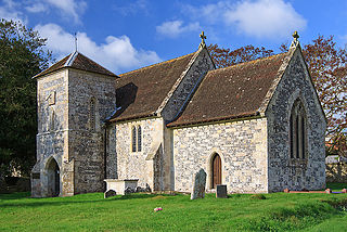
Berwick St Leonard is a small village and civil parish in Wiltshire, England, about 8 miles (13 km) southeast of Warminster and 14 miles (23 km) west of Salisbury.

<span class="mw-page-title-main">Boyton, Wiltshire</span> Village in Wiltshire, England

Boyton is a village and civil parish in Wiltshire, England. It lies in the Wylye Valley within Salisbury Plain, about 6 miles (10 km) south-east of Warminster and 13 miles (21 km) north-west of Salisbury. The parish includes the village of Corton.

<span class="mw-page-title-main">Wiltshire Victoria County History</span> Encyclopaedic history of the county of Wiltshire in England

The Wiltshire Victoria County History, properly called The Victoria History of the County of Wiltshire but commonly referred to as VCH Wiltshire, is an encyclopaedic history of the county of Wiltshire in England. It forms part of the overall Victoria County History of England founded in 1899 in honour of Queen Victoria. With eighteen volumes published in the series, it is now the most substantial of the Victoria County Histories.

<span class="mw-page-title-main">Norton Bavant</span> Human settlement in England

Norton Bavant is a small village and civil parish in Wiltshire, England, 2 miles (3.2 km) southeast of Warminster.

<span class="mw-page-title-main">Knook</span> Human settlement in England

Knook is a small village and civil parish in Wiltshire, England. The village lies to the north of the River Wylye at the edge of Salisbury Plain, about 4+12 miles (7 km) southeast of Warminster, close to the A36 road to Salisbury.

<span class="mw-page-title-main">Marden, Wiltshire</span> Human settlement in England

Marden is a small village and civil parish 6 miles (9.7 km) southeast of Devizes in the county of Wiltshire, south west England. The parish is in the Vale of Pewsey which carries the upper section of the Salisbury Avon; to the south the parish extends into Salisbury Plain.

<span class="mw-page-title-main">East Knoyle</span> English village in Wiltshire

East Knoyle is a village and civil parish in Wiltshire, in the south-west of England, just west of the A350 and about 9 miles (14 km) south of Warminster and 5 miles (8 km) north of Shaftesbury, Dorset. It was the birthplace of the architect Sir Christopher Wren. The parish includes the hamlets of Holloway, Milton, The Green, Underhill and Upton.

<span class="mw-page-title-main">Teffont Evias</span> Human settlement in England

Teffont Evias is a small village and former civil parish, now in the parish of Teffont, on the Nadder valley in the south of Wiltshire, England. Edric Holmes described the village as "most delightfully situated", and Maurice Hewlett included Teffont in his list of the half dozen most beautiful villages in England. The present buildings are mostly of local stone, and several are thatched.

<span class="mw-page-title-main">Teffont Magna</span> Human settlement in England

Teffont Magna, sometimes called Upper Teffont, is a small village and former civil parish, now in the parish of Teffont, in the Nadder valley in the south of the county of Wiltshire, England. For most of its history, Teffont Magna was a chapelry of neighbouring Dinton. In 1934 it was combined with the parish of Teffont Evias, just to the south, to form a united Teffont parish.

<span class="mw-page-title-main">Pertwood</span> Human settlement in England

Pertwood is an ancient settlement and former civil parish, near Warminster in the county of Wiltshire in the west of England. Its land and houses now lie in the parishes of Brixton Deverill, East Knoyle, Sutton Veny and Chicklade, and have fewer than twenty inhabitants.

<span class="mw-page-title-main">Hannington, Wiltshire</span> Village in Wiltshire, England

Hannington is a village and civil parish in Wiltshire, England, about 2 miles (3.2 km) north-west of Highworth, within the Borough of Swindon. The parish includes the hamlets of Hannington Wick and Swanborough. The River Thames forms both the northern boundary of the parish and the county boundary with Gloucestershire.

<span class="mw-page-title-main">Stratford Tony</span> Human settlement in England

Stratford Tony, also spelt Stratford Toney, formerly known as Stratford St Anthony and Toney Stratford, is a small village and civil parish in southern Wiltshire, England. It lies on the River Ebble and is about 4 miles (6.4 km) southwest of Salisbury.

<span class="mw-page-title-main">Wardour, Wiltshire</span> Human settlement in England

Wardour is a settlement in the civil parish of Tisbury, in Wiltshire, England, about 13 miles (21 km) west of Salisbury and 4 miles (6 km) south of Hindon.

<span class="mw-page-title-main">Tytherington, Wiltshire</span> Village in Wiltshire, England

Tytherington is a small village in Wiltshire, in the southwest of England. It lies on the south side of the Wylye valley, about 3+12 miles (6 km) southeast of the town of Warminster and 1 mile (1.6 km) southwest of the larger village of Heytesbury. Most of the village is now part of the civil parish of Heytesbury although a few houses in the west are within the parish of Sutton Veny.

<span class="mw-page-title-main">Boscombe, Wiltshire</span> Human settlement in England

Boscombe is a small village and former civil parish, now in the parish of Allington, Wiltshire, England. It lies about 3 miles (5 km) southeast of Amesbury on the banks of the River Bourne, on the A338 road which follows the Bourne on its way from Salisbury to Tidworth and beyond.

References

  1. "Chicklade Census Information". Wiltshire Community History. Wiltshire Council. Retrieved 22 March 2013. Note ONS raw data (as opposed to this County Council figure) is for an area 'too small to publish all data for reasons of confidentiality of living people' its parish data being combined with much of Hindon, Wiltshire into output area E00163258 so more demographic statistics will become available in a few decades from 2011
  2. Eilert Ekwall, Studies on English Place-names (Wahlström & Widstrand, 1936), p. 197.
  3. Coates, Richard; Breeze, Andrew (2000). Celtic Voices, English Places: Studies of the Celtic Impact on Place-Names in Britain. Stamford: Tyas. ISBN   1900289415..
  4. Wilson 1870–1872 , p. 425
  5. Historic England. "Church of All Saints (1318426)". National Heritage List for England . Retrieved 27 March 2016.
  6. Crowley, D.A. (ed.). "Victoria County History – Wiltshire – Vol 13 pp105-114 – Chicklade". British History Online. University of London. Retrieved 27 March 2016.
  7. Chicklade, Wiltshire at genuki.org.uk
  8. "Chicklade Parish Meeting". Wiltshire Council. Retrieved 27 March 2016.

Sources and further reading

Commons-logo.svg Media related to Chicklade at Wikimedia Commons