Karst is a topography formed from the dissolution of soluble rocks such as limestone, dolomite, and gypsum. It is characterized by underground drainage systems with sinkholes and caves. It has also been documented for more weathering-resistant rocks, such as quartzite, given the right conditions. Subterranean drainage may limit surface water, with few to no rivers or lakes. However, in regions where the dissolved bedrock is covered or confined by one or more superimposed non-soluble rock strata, distinctive karst features may occur only at subsurface levels and be totally missing above ground.

Geomorphology is the scientific study of the origin and evolution of topographic and bathymetric features created by physical, chemical or biological processes operating at or near the Earth's surface. Geomorphologists seek to understand why landscapes look the way they do, to understand landform history and dynamics and to predict changes through a combination of field observations, physical experiments and numerical modeling. Geomorphologists work within disciplines such as physical geography, geology, geodesy, engineering geology, archaeology, climatology and geotechnical engineering. This broad base of interests contributes to many research styles and interests within the field.
The exposed geology of the Bryce Canyon area in Utah shows a record of deposition that covers the last part of the Cretaceous Period and the first half of the Cenozoic era in that part of North America. The ancient depositional environment of the region around what is now Bryce Canyon National Park varied from the warm shallow sea in which the Dakota Sandstone and the Tropic Shale were deposited to the cool streams and lakes that contributed sediment to the colorful Claron Formation that dominates the park's amphitheaters.

A cuesta is a hill or ridge with a gentle slope on one side, and a steep slope on the other. In geology the term is more specifically applied to a ridge where a harder sedimentary rock overlies a softer layer, the whole being tilted somewhat from the horizontal. This results in a long and gentle backslope called a dip slope that conforms with the dip of resistant strata, called caprock. Where erosion has exposed the frontslope of this, a steep slope or escarpment occurs. The resulting terrain may be called scarpland.

Sanming ) is a prefecture-level city in western Fujian province, China. It borders Nanping City to the north, Fuzhou City to the east, Quanzhou City to the southeast, Longyan City to the south, and the province of Jiangxi to the west. Sanming lies between Wuyi and Daiyun mountains.

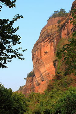
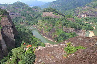
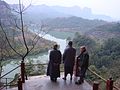
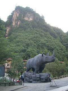
Mount Danxia is a noted scenic mountainous area near Shaoguan city in the northern part of Guangdong, People's Republic of China.
The geographic cycle or cycle of erosion is an idealized model that explains the development of relief in landscapes. The model starts with the erosion that follows uplift of land above a base level and ends – if conditions allow – in the formation of a peneplain. Landscapes that show evidence of more than one cycle of erosion are termed "polycyclical". The cycle of erosion and some of its associated concepts have, despite popularity, been a subject of much criticism.

In geology and geomorphology, a hogback or hog's back is a long, narrow ridge or a series of hills with a narrow crest and steep slopes of nearly equal inclination on both flanks. Typically, the term is restricted to a ridge created by the differential erosion of outcropping, steeply dipping, homoclinal, and typically sedimentary strata. One side of a hogback consists of the surface of a steeply dipping rock stratum called a dip slope. The other side is an erosion face that cuts through the dipping strata that comprises the hogback. The name "hogback" comes from the Hog's Back of the North Downs in Surrey, England, which refers to the landform's resemblance in outline to the back of a hog. The term is also sometimes applied to drumlins and, in Maine, to both eskers and ridges known as "horsebacks".
The Geology of China can be divided into several parts. The historical centre of Chinese culture is on the loess plateau, the world's largest Quaternary loess deposit, and on the alluvial lands at the east of it. The alluvial East China plain extends from just south of Beijing in the north, to the Yangzi river delta in the south, punctuated only by the igneous Shandong highlands and peninsula. South of the Yangzi river, most of the landscape is mountainous, dominated by sedimentary deposits and by the Yangzi craton. The most famous scenery in China is found in the karst landscapes of Guangxi and Yunnan provinces. The alluvial Sichuan basin is surrounded by mountains, the Qinling mountains to the north and the Himalaya to the west and southwest. Much of Northeast China, or Manchuria, is dominated by alluvial plains, but the border regions with Korea are also highly mountainous. In the west, most of the Tibetan plateau is in China, and averages over 4000 metres in elevation. The Yunnan-Guizhou plateau is also an extension of the Tibetan plateau.

The Stone Forest or Shilin is a notable set of limestone formations about 500 km2 located in Shilin Yi Autonomous County, Yunnan Province, People's Republic of China, near Shilin approximately 90 km (56 mi) from the provincial capital Kunming.

The interaction between erosion and tectonics has been a topic of debate since the early 1990s. While the tectonic effects on surface processes such as erosion have long been recognized, the opposite has only recently been addressed. The primary questions surrounding this topic are what types of interactions exist between erosion and tectonics and what are the implications of these interactions. While this is still a matter of debate, one thing is clear, the Earth's landscape is a product of two factors: tectonics, which can create topography and maintain relief through surface and rock uplift, and climate, which mediates the erosional processes that wear away upland areas over time. The interaction of these processes can form, modify, or destroy geomorphic features on the Earth’s surface.

The Lower Permian Esplanade Sandstone is a cliff-forming, resistant sandstone, dark red, geologic unit found in the Grand Canyon. The rock unit forms a resistant shelf in the west Grand Canyon, south side of the Colorado River, at the east of the Toroweap Fault, down-dropped to west, southeast of Toroweap Overlook, and west of Havasupai. The red, sandstone shelf, The Esplanade is about 20-mi long. At Toroweap Overlook region, Toroweap Valley with Vulcan's Throne, Uinkaret volcanic field, the resistant Esplanade Sandstone is described in access routes exploring the Toroweap Lake area.

The early Late Triassic conglomerate called the Shinarump Conglomerate, formally the Shinarump Member of the Chinle Formation, is a highly resistant coarse-grained sandstone and pebble conglomerate, sometimes forming a caprock because of its hardness, cementation, and erosion resistance. The Shinarump is found throughout the Colorado Plateau with significant exposures as the canyon rimrock in the vicinity of Canyon De Chelly National Monument, at the north-northeast of the Defiance Plateau/Defiance Uplift. At Canyon De Chelly the Shinarump Conglomerate was laid down upon De Chelly Sandstone-(280 Ma, an erosion unconformity of 50 my), in a region at the west foothill region of the mostly north-south trending Chuska Mountains of northeast Arizona – northwest New Mexico.

The Zhangye National Geopark is located in Sunan and Linze counties within the prefecture-level city of Zhangye, in Gansu, China. It covers an area of 322 square kilometres (124 sq mi). The site became a quasi-national geopark on April 23, 2012. It was formally designated as "Zhangye National Geopark" by the Ministry of Land and Resources on June 16, 2016 after it has passed the on-site acceptance test. Known for its colorful rock formations, it has been voted by Chinese media outlets as one of the most beautiful landforms in China.
A fin is a geologic formation that is a narrow, residual wall of hard sedimentary rock that remains standing after surrounding rock has been eroded away along parallel joints or fractures. Fins are formed when a narrow butte or plateau develops many vertical, parallel cracks. There are two main modes of following erosion. The first is when water flows along joints and fractures and opens them wider and wider, eventually causing erosion. The second is where the rock type (stratum) is harder and more erosion resistant than neighboring rocks, causing the weaker rock to fall away.
The geology of Guam formed as a result of mafic, felsic and intermediate composition volcanic rocks erupting below the ocean, building up the base of the island in the Eocene, between 33.9 and 56 million years ago. The island emerged above the water in the Eocene, although the volcanic crater collapsed. A second volcanic crater formed on the south of the island in the Oligocene and Miocene. In the shallow water, numerous limestone formations took shape, with thick alternating layers of volcanic material. The second crater collapsed and Guam went through a period in which it was almost entirely submerged, resembling a swampy atoll, until structural deformation slowly uplifted different parts of the island to their present topography. The process of uplift led to widespread erosion and clay formation, as well as the deposition of different types of limestone, reflecting different water depths.
The geology of Colorado was assembled from island arcs accreted onto the edge of the ancient Wyoming Craton. The Sonoma orogeny uplifted the ancestral Rocky Mountains in parallel with the diversification of multicellular life. Shallow seas covered the regions, followed by the uplift current Rocky Mountains and intense volcanic activity. Colorado has thick sedimentary sequences with oil, gas and coal deposits, as well as base metals and other minerals.