Chorfa | |
|---|---|
Commune and town | |
 | |
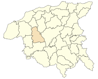
 Location of Chorfa within Mascara Province | |
| Country | |
| Province | Mascara Province |
| Population (2002) | |
| • Total | 14,850 |
Chorfa is a town and commune in Mascara Province, Algeria. The population in 2002 was 14,850. [1]
Chorfa | |
|---|---|
Commune and town | |
| | |
| Location of Chorfa within Mascara Province | |
| Country | |
| Province | Mascara Province |
| Population (2002) | |
| • Total | 14,850 |
Chorfa is a town and commune in Mascara Province, Algeria. The population in 2002 was 14,850. [1]

Oakwood Hills is a village in McHenry County, Illinois, United States. Oakwood Hills was founded in 1959. The population was 2,083 at the 2010 census. As of 2018, the population dropped to 2,041.

Virginia is a village in Gage County, Nebraska, United States. The population was 60 at the 2010 census.

Federal Dam is a city in Cass County, Minnesota, United States, near Leech Lake. The population was 110 at the 2010 census. It is part of the Brainerd Micropolitan Statistical Area.

Marmet is a city in Kanawha County, West Virginia, United States, along the Kanawha River. The population was 1,501 at the 2020 census.
Arlington is a town in Columbia County, Wisconsin, United States. The population was 848 at the 2000 census. The Village of Arlington is located within the town.

The Lavender Pit is a former open pit copper mine near Bisbee in Cochise County, Arizona, United States. It is located near the famous Copper Queen Mine. The Lavender Pit was named in honor of Harrison M. Lavender (1890–1952), who as Vice-President and General Manager of Phelps Dodge Corporation, conceived and carried out this plan for making the previously unprofitable low-grade copper bearing rock of the area into commercial copper ore.
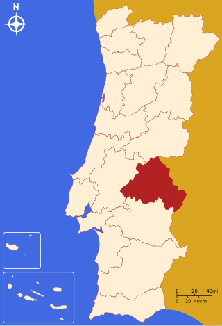
Portalegre District is located in the east of Portugal. The district capital is the city of Portalegre.

Texas's 19th congressional district of the United States House of Representatives includes the upper midwestern portion of the state of Texas. The district includes portions of the State from Lubbock to Abilene. The current Representative from the 19th district is Republican Jodey Arrington.
Moween, Pennsylvania is a small village located on the Conemaugh River and is part of Loyalhanna Township. The approximate population is 150 residents. School age children in the village of Moween attend Saltsburg Jr./Sr. High School. Businesses in and around Moween include Hoovers Stone Quarry and Tuscano-Maher Roofing, Inc.
Fishtrap Lake is a 1,130-acre (5 km2) reservoir in Pike County, Kentucky. Dedicated by President Lyndon B. Johnson in 1968, the lake was formed by the impounding of the Levisa Fork of the Big Sandy River at the 195-foot-high Fishtrap Dam by the United States Army Corps of Engineers.
Model is an abandoned unincorporated village in Las Animas County, Colorado, United States. The Model Post Office serving ZIP Code 81059 was in operation from 1912 to 2021, and was the last business or service standing there for many years. The community originally was a planned, or "model" community, hence the name.

Roberto Payán is a town and municipality in the Nariño Department, Colombia. The municipal seat is known as San José de las Lagunas.
Royalston Falls is a 50 foot (15 m) waterfall and granite gorge located in Royalston, Massachusetts along Falls Brook, a tributary of the Tully River which in turn is a tributary of the Millers River. The falls are part of a 217-acre (88 ha) open space preserve acquired in 1951 by the land conservation non-profit organization The Trustees of Reservations. The 22-mile (35 km) Tully Trail and the 110-mile (180 km) Metacomet-Monadnock Trail, a National Recreation Trail, pass through the property.
Cego is a very small unincorporated community in west Falls County, Texas, United States. Cego is located on Farm-to-market road 1950. As of 2000, the population was 42.

Wilton Center is a neighborhood/section and census-designated place (CDP) in the town of Wilton in Fairfield County, Connecticut, United States. As of the 2010 census it had a population of 732. The CDP partially overlaps the Wilton Center Historic District.

Bluie was the United States military code name for Greenland during World War II. It is remembered by the numbered sequence of base locations identified by the 1941 United States Coast Guard South Greenland Survey Expedition, and subsequently used in radio communications by airmen unfamiliar with pronunciation of the Inuit and Old Norse names of those locations. These were typically spoken BLUIE (direction) (number), with direction being east or west along the Greenland coast from Cape Farewell.
Harenfa is a town and commune in Chlef Province, Algeria.
Denaro is an unincorporated community located in Amelia County, in the U.S. state of Virginia. Denaro is located 0.4 miles north of the Amelia-Nottoway county line at the split & curve junctions of SR 614 and SR 613. The community was a post village in the 1900s, the post office has since closed.

The Tataskweyak Cree Nation is a First Nations band government whose primary community is located at Split Lake, Manitoba, on the Nelson River system. Despite its remote location, it is serviced by Provincial Road 280, which connects the community to Thompson.
Belfort is an unincorporated community in Stark County, in the U.S. state of Ohio.
Coordinates: 35°25′55″N0°14′43″W / 35.43194°N 0.24528°W
| | This article about a location in Mascara Province is a stub. You can help Wikipedia by expanding it. |
