Khalouia | |
|---|---|
Commune and town | |
| Country | |
| Province | Mascara Province |
| Population (1998) | |
| • Total | 4,984 |
| Time zone | UTC+1 (CET) |
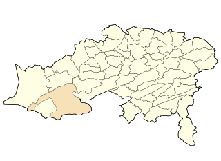
Khalouia is a town and commune in Mascara Province, Algeria. According to the 1998 census it has a population of 4,984. [1]
Khalouia | |
|---|---|
Commune and town | |
| Country | |
| Province | Mascara Province |
| Population (1998) | |
| • Total | 4,984 |
| Time zone | UTC+1 (CET) |
Khalouia is a town and commune in Mascara Province, Algeria. According to the 1998 census it has a population of 4,984. [1]

Beni Saf is a town in northwestern Algeria, about 80 kilometers southwest of Oran. The town was founded in 1876 as a shipping port for iron ore, which is mined just south of the town. Other products of the town include zinc, marble and onyx, and the fishing industry is extensive.

Aïn Djasser is a town in north-eastern Algeria.
Bitam, Algeria is a town in north-eastern Algeria.

Ichmoul is a town in north-eastern Algeria.
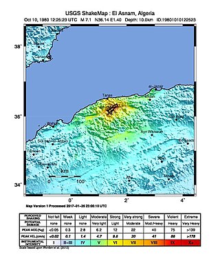
The 1980 El Asnam earthquake occurred on October 10 at 13:25:23 local time with a moment magnitude of 7.1 and a maximum Mercalli intensity of X (Extreme). The shock occurred in the Algerian town of El Asnam. The shocks were felt over 550 km (340 mi) away, with the initial earthquake lasting 35 seconds. It was the largest earthquake in Algeria, and was followed three hours later by a magnitude 6.2 aftershock. The earthquake created about 42 km (26 mi) of surface rupture and had a vertical slip of up to 4.2 m (14 ft). No foreshocks were recorded. The earthquake was found to have occurred very close to the epicenter of the 1954 Chlef earthquake using joint epicenter determination techniques. It occurred at a previously unknown reverse fault.

Aïn Djasser District is a district of Batna Province, Algeria.

Ichmoul District is a district of Batna Province, Algeria.

Ouled Si Slimane District is a district of Batna Province, Algeria.
El Affroun العفرون البليدة is a town and commune in Blida Province, Algeria. According to the 2022 census it has a population of 42,627

Froha is a town and commune in Mascara Province, Algeria. According to the 1998 census it has a population of 11,969.
Zorg, Algeria is a town and commune in Oum El Bouaghi Province, Algeria. According to the 1998 census it has a population of 1,736.

El Matmar is a town and commune in Relizane Province, Algeria.
Beni Aziz is a town and commune in Sétif Province in north-eastern Algeria.
Taya is a town and commune in Sétif Province in north-eastern Algeria.

Oum Ali is a town and commune in Tébessa Province in north-eastern Algeria, near the border with Algeria.
Sidi Hosni is a town and commune in Tiaret Province in north-western Algeria.
Sidi Djillali is a town and commune in Tlemcen Province in north-western Algeria.
Mian Jam Rural District is a rural district (dehestan) in the Central District of Torbat-e Jam County, Razavi Khorasan Province, Iran. At the 2006 census, its population was 22,862, in 5,076 families. The rural district has 34 villages.
In the Battle of Sig, French forces, assisted by the Douair and Smela tribes, fought the Algerian resistance led by Emir Abdelkader in the forest of Moulay-Ismaël near Sig for 2 days.
Coordinates: 35°28′N0°18′E / 35.467°N 0.300°E
| | This article about a location in Mascara Province is a stub. You can help Wikipedia by expanding it. |
