Murray River National Park is a protected area in South Australia located between 180 kilometres (110 mi) and 240 km (150 mi) north east of the Adelaide city centre, lying along the Murray River. The national park is classified as an IUCN Category VI protected area. As of 2022 the national park comprises more than 14,879 ha, and includes a vast network of Murray River wetlands and floodplains.
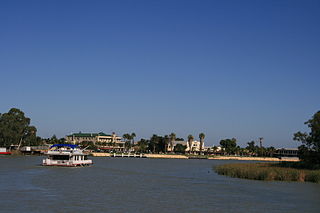
Renmark is a town in South Australia's rural Riverland area, and is located 254 km (157.83 mi) northeast of Adelaide, on the banks of the River Murray. The Sturt Highway between Adelaide and Sydney runs through the town; Renmark is the last major town encountered in South Australia when driving this route. It is a few kilometres west of the SA–Victoria and SA–NSW borders. It is 31 m (101.71 ft) above sea level.

The Riverland is a region of South Australia. It covers an area of 9,386 square kilometres (3,624 sq mi) along the River Murray from where it flows into South Australia from New South Wales and Victoria downstream to Blanchetown. The major town centres are Renmark, Berri, Loxton, Waikerie, Barmera and Monash, and many minor townships. The population is approximately 35,000 people.
Loxton is a town on the south bank of the River Murray in the Riverland region of South Australia. It is located on the lands of the Erawirung people who occupied the area before the arrival of Europeans.

Blanchetown is a small township in South Australia, on the (west) bank of the Murray River, 130 kilometres (81 mi) northeast of Adelaide. The Blanchetown Bridge is the westernmost of the four crossings of the Sturt Highway over the Murray River. During the nineteenth century it was an important transportation centre on the lower Murray. In the early 21st century, Blanchetown has been described as "a strange mixture of historic buildings and temporary shacks built by holidaymakers on the banks of the river". Blanchetown is widely regarded as the entrance to the Riverland district.

The Riverland Biosphere Reserve, formerly the Bookmark Biosphere Reserve, is a 9,000 square kilometres area of land in eastern South Australia, adjoining the states of New South Wales and Victoria. It is one of 14 biosphere reserves in Australia and is part of the World Network of Biosphere Reserves, being officially recognized and listed by UNESCO in 1977.
Danggali Conservation Park is a protected area located about 65 kilometres north of Renmark in South Australia. The conservation park was proclaimed under the National Parks and Wildlife Act 1972 in 1976. In 2009, a portion of the conservation park was excised to create the Danggali Wilderness Protection Area. The conservation park is classified as an IUCN Category Ia protected area.
The Riverland Mallee Important Bird Area comprises a 12,200 square kilometres tract of mallee habitat and riverine woodland extending from near Waikerie in the Riverland region in eastern South Australia north-eastwards into south-western New South Wales.
Overland Corner is a locality in the Australian state of South Australia located in the state’s east about 181 kilometres (112 mi) north-east of the state capital of Adelaide and about 30 kilometres (19 mi) west of the municipal seat in Berri.
Chowilla Regional Reserve is protected area in the Australian state of South Australia located in the gazetted locality of Chowilla about 250 kilometres (160 mi) north-east of the state capital of Adelaide.
Chowilla Game Reserve is a protected area covering the floodplain on the north side of the River Murray in South Australia from about 8 kilometres north-east of Renmark to the New South Wales border. It was proclaimed 8 April 1993 in conjunction with the Chowilla Regional Reserve, after a community consultation process which recommended that "hunting of waterfowl be a permitted activity in selected areas of the Chowilla floodplain". The game reserve is classified as an IUCN Category VI protected area.
Danggali is a locality in the Australian state of South Australia located about 70 kilometres north of the town of Renmark and about 230 kilometres north east of the state capital of Adelaide.
Cooltong Conservation Park is a protected area located in South Australia about 6 kilometres west of the town of Renmark in the Riverland of South Australia. The conservation park was proclaimed under the National Parks and Wildlife Act 1972 in 1993 to "preserve quality mallee vegetation and habitat for the mallee bird species that frequent the area, in particular the Malleefowl." As of 2011, the conservation park was described as being "dominated by mallee vegetation, with undulating dunes and shales" and that it is "popular among birdwatchers eager to catch a glimpse of elusive mallee birds." Services provided within the conservation park as of 2011 include bushwalking, picnic grounds and vehicle tracks only accessible by 4WD vehicles. The conservation park is classified as an IUCN Category VI protected area.
Murtho is a locality in South Australia. It is northeast of Renmark and Paringa. It is bounded by the Murray River on its north and west sides and the Victorian border on the east.
The Chowilla floodplain is a floodplain adjacent to the Murray River, upstream of Renmark, South Australia. The floodplain includes the Chowilla Game Reserve and Chowilla Regional Reserve, and also extends across the state border into New South Wales.
Calperum Station is a locality in the Australian state of South Australia located on the northern side of the Murray River about 10 kilometres to the north of the town of Renmark and about 250 kilometres east of the centre of the capital city of Adelaide.
Taylorville Station is a protected area located in the east of the Australian state of South Australia about 35 kilometres north west of the town of Renmark and about 250 kilometres east of the state capital of Adelaide. It is a protected area which is under the control of the Australian government rather than the Government of South Australia and which is managed by a private organisation under contract. Taylorville Station is part of an area whose habitat has been listed as "critical" for the survival of the bird species, black-eared miner. It is also part of a larger reserve system known as the Riverland Biosphere Reserve.

Calperum Station, also known as Calperum Reserve, is a nature reserve located in the east of the Australian state of South Australia about 10 kilometres north-west of the town of Renmark and about 250 kilometres east of the state capital of Adelaide. Calperum Station consists of three separate pastoral leases - Calperum, Calperum Road and Yubalia.
Mundic Creek is a locality in the Australian state of South Australia located in the Riverland in the state's east on the southern side of the Murray River about 217 kilometres (135 mi) north-east of the state capital of Adelaide, and about 6 kilometres (3.7 mi) south-east of the municipal seat of Renmark.
Pike River is a locality in the Australian state of South Australia located in the Riverland in the state’s east on the southern side of the Murray River about 210 kilometres (130 mi) north-east of the state capital of Adelaide and about 9 kilometres (5.6 mi) south-east of the municipal seat of Renmark.

