Alaska is a state located in the Western United States on the northwest extremity of North America. A semi-exclave of the U.S., it borders the Canadian province of British Columbia and the Yukon territory to the east; it also shares a maritime border with the Russian Federation's Chukotka Autonomous Okrug to the west, just across the Bering Strait. To the north are the Chukchi and Beaufort seas of the Arctic Ocean, while the Pacific Ocean lies to the south and southwest.

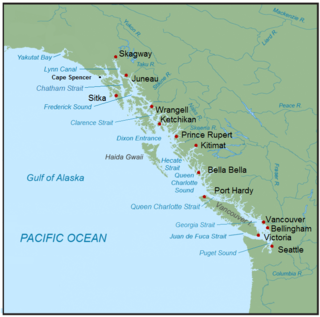
Southeast Alaska, colloquially referred to as the Alaska Panhandle or Alaskan Panhandle, is the southeastern portion of the U.S. state of Alaska, bordered to the east by the northern half of the Canadian province of British Columbia. The majority of Southeast Alaska's area is part of the Tongass National Forest, the United States' largest national forest. In many places, the international border runs along the crest of the Boundary Ranges of the Coast Mountains. The region is noted for its scenery and mild, rainy climate.

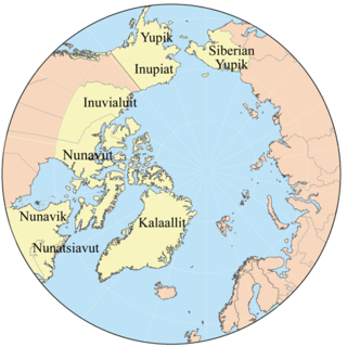
Eskimo is an exonym used to refer to two closely related Indigenous peoples: the Inuit and the Yupik of eastern Siberia and Alaska. A related third group, the Aleut, which inhabit the Aleutian Islands, are generally excluded from the definition of Eskimo. The three groups share a relatively recent common ancestor, and speak related languages belonging to the Eskimo–Aleut language family.

Yukon is the smallest and westernmost of Canada's three territories. It also is the second-least populated province or territory in Canada, with a population of 40,232 people as of the 2021 Census. Whitehorse, the territorial capital, is the largest settlement in any of the three territories.

The Tlingit are indigenous peoples of the Pacific Northwest Coast of North America. Their language is the Tlingit language, in which the name means 'People of the Tides'. The Russian name Koloshi or the related German name Koulischen may be encountered referring to the people in older historical literature, such as Grigory Shelikhov's 1796 map of Russian America.

Totem poles are monumental carvings, a type of Northwest Coast art, consisting of poles, posts or pillars, carved with symbols or figures. They are usually made from large trees, mostly western red cedar, by First Nations and Indigenous peoples of the Pacific Northwest Coast including northern Northwest Coast Haida, Tlingit, and Tsimshian communities in Southeast Alaska and British Columbia, Kwakwaka'wakw and Nuu-chah-nulth communities in southern British Columbia, and the Coast Salish communities in Washington and British Columbia.

The contiguous United States or officially the conterminous United States, also known as the Lower 48, consists of the 48 adjoining U.S. states and the District of Columbia on the continent of North America. The terms exclude the non-contiguous states of Alaska and Hawaii and all other offshore insular areas, such as American Samoa, Guam, the Northern Mariana Islands, Puerto Rico, and the U.S. Virgin Islands. These differ from the related term continental United States, which includes Alaska but excludes the Hawaiian Islands and all U.S. territories in the Caribbean and the Pacific.

The City and Borough of Juneau, more commonly known simply as Juneau, is the capital city of the state of Alaska. Located in the Gastineau Channel and the Alaskan panhandle, it is a unified municipality and the second-largest city in the United States by area. Juneau was named the capital of Alaska in 1906, when the government of what was then the District of Alaska was moved from Sitka as dictated by the U.S. Congress in 1900. The municipality unified on July 1, 1970, when the city of Juneau merged with the city of Douglas and the surrounding Greater Juneau Borough to form the current municipality, which is larger by area than both Rhode Island and Delaware.
The Alaska Highway was constructed during World War II to connect the contiguous United States to Alaska across Canada. It begins at the junction with several Canadian highways in Dawson Creek, British Columbia, and runs to Delta Junction, Alaska, via Whitehorse, Yukon. When it was completed in 1942, it was about 2,700 kilometres (1,700 mi) long, but in 2012, it was only 2,232 km (1,387 mi). This is due to the continuing reconstruction of the highway, which has rerouted and straightened many sections. The highway opened to the public in 1948. Once legendary for being a rough, challenging drive, the highway is now paved over its entire length. Its component highways are British Columbia Highway 97, Yukon Highway 1 and Alaska Route 2.

The 1964 Alaskan earthquake, also known as the Great Alaskan earthquake and Good Friday earthquake, occurred at 5:36 PM AKST on Good Friday, March 27. Across south-central Alaska, ground fissures, collapsing structures, and tsunamis resulting from the earthquake caused about 131 deaths.

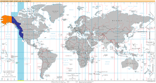
The Pacific Time Zone (PT) is a time zone encompassing parts of western Canada, the western United States, and western Mexico. Places in this zone observe standard time by subtracting eight hours from Coordinated Universal Time (UTC−08:00). During daylight saving time, a time offset of UTC−07:00 is used.

The Alaska boundary dispute was a territorial dispute between the United States and the United Kingdom, which then controlled Canada's foreign relations. It was resolved by arbitration in 1903. The dispute had existed between the Russian Empire and Britain since 1821, and was inherited by the United States as a consequence of the Alaska Purchase in 1867. The final resolution favored the American position, as Canada did not get an all-Canadian outlet from the Yukon gold fields to the sea. The disappointment and anger in Canada was directed less at the United States, and more at the British government for betraying Canadian interests in favor of healthier Anglo-American relations.

The Inside Passage is a coastal route for ships and boats along a network of passages which weave through the islands on the Pacific Northwest coast of the North American Fjordland. The route extends from southeastern Alaska in the United States, through western British Columbia in Canada, to northwestern Washington state in the United States. Ships using the route can avoid some of the bad weather in the open ocean and may visit some of the many isolated communities along the route. The Inside Passage is heavily travelled by cruise ships, freighters, tugs with tows, fishing craft, pleasure craft, and ships of the Alaska Marine Highway, BC Ferries, and Washington State Ferries systems. Coast Guard vessels of both Canada and the United States patrol and transit in the Passage.

The Gwichʼin are an Athabaskan-speaking First Nations people of Canada and an Alaska Native people. They live in the northwestern part of North America, mostly above the Arctic Circle.

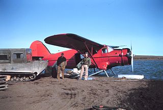
Bush flying refers to aircraft operations carried out in the bush. Bush flying involves operations in rough terrain where there are often no prepared landing strips or runways, frequently necessitating that bush planes be equipped with abnormally large tires, floats, skis or any other equipment necessary for unpaved runway operation. It is the only viable way of delivering people and supplies into more difficult to reach, remote locations.

UTC−08:00 is an identifier for a time offset from UTC of −08:00. This time is used:

Kiskatinaw Provincial Park is a provincial park located in Peace River Regional District in British Columbia, Canada. It was established on May 1, 1962 to protect a prominent horseshoe-shaped incised meander in the Kiskatinaw River where a historic curved bridge crosses the river along the original alignment of the Alaska Highway.

Alaska occupies the northwestern portion of the North American continent and is bordered only by Canada on the east. It is one of two U.S. states not bordered by another state; Hawaii is the other. Alaska has more ocean coastline than all of the other U.S. states combined. About 500 miles (800 km) of Canadian territory separate Alaska from Washington state. Alaska is thus an exclave of the United States that is part of the continental U.S. and the U.S. West Coast, but is not part of the contiguous U.S. Alaska is also the only state, other than Hawaii, whose capital city is accessible only via ship or air, because no roads connect Juneau to the rest of the continent.

Inuit are a group of culturally similar indigenous peoples inhabiting the Arctic and subarctic regions of Greenland (Denmark), Canada, and Alaska. The Inuit languages are part of the Eskimo–Aleut languages also known as Inuit-Yupik-Unangan and also as Eskaleut. Inuit Sign Language is a critically endangered language isolate used in Nunavut.


