Cimarron, Colorado Last updated June 03, 2025
Unincorporated community in State of Colorado, United States
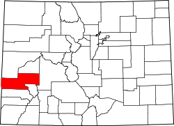
Cimarron is an unincorporated rural hamlet in Montrose County , Colorado , United States. It is located on the northern side of U.S. Highway 50 , 19 miles from the town of Montrose to its west, and 42 miles from Gunnison, Colorado to its east. There is a store with fuel pumps and a post office at Cimarron. The post office services the rural ZIP Code 81220 area. [ 2]
Cimarron is located along the Cimarron River , just south of the Black Canyon of the Gunnison , and just outside Curecanti National Recreation Area . The D & RG Narrow Gauge Trestle crosses the Cimarron River gorge just northeast of town, and is on the National Register of Historic Places (#76000172).
Round-up in a ranch just south of the town, 1898. Climate Cimarron has a humid continental climate (Köppen Dfb ), bordering on a cold semi-arid climate (Köppen BSk ).
Climate data for Cimarron, Colorado, 1991–2020 normals, 1951-2020 records: 6890ft (2100m) Month Jan Feb Mar Apr May Jun Jul Aug Sep Oct Nov Dec Year Record high °F (°C) 60 65 81 85 91 96 98 94 94 86 78 61 98 Mean maximum °F (°C) 47.6 51.8 65.0 73.1 81.7 88.9 92.3 89.8 86.1 77.5 64.7 50.7 92.7 Mean daily maximum °F (°C) 34.8 39.6 51.0 60.0 70.2 80.9 85.5 83.0 76.3 64.3 48.7 35.9 60.9 Daily mean °F (°C) 18.8 24.7 34.8 43.0 51.1 59.2 65.4 63.8 56.4 45.0 32.5 21.0 43.0 Mean daily minimum °F (°C) 2.7 9.8 18.6 26.1 32.0 37.5 45.3 44.6 36.5 25.7 16.4 6.0 25.1 Mean minimum °F (°C) −18.4 −15.1 −1.4 12.0 20.1 27.5 34.6 34.3 23.2 10.6 −4.8 −17.6 −23.9 Record low °F (°C) −43 −40 −26 −9 4 19 29 27 13 −8 −24 −33 −43 Average precipitation inches (mm) 1.09 0.94 0.91 1.22 1.28 0.68 1.37 1.41 1.82 1.35 1.04 1.17 14.28 Average snowfall inches (cm) 14.50 11.60 8.20 5.70 1.10 0.00 0.00 0.00 0.00 1.40 9.70 14.50 66.7 Source 1: NOAA [ 3] Source 2: XMACIS2 (records & monthly max/mins) [ 4]
Montrose 11 ENE is a weather station near Cimarron. [ 5] Montrose 11 ENE also has a humid continental climate (Köppen Dfb ), but with a lower diurnal variation and a higher level of precipitation.
Climate data for Montrose 11 ENE, Colorado, 1991–2020 normals, 2004-2020 snowfall: 8402ft (2561m) Month Jan Feb Mar Apr May Jun Jul Aug Sep Oct Nov Dec Year Record high °F (°C) 50 55 68 73 79 88 89 87 85 76 64 52 89 Mean maximum °F (°C) 43.6 46.1 56.5 66.5 73.9 82.4 85.1 83.0 79.0 69.4 59.8 46.5 85.6 Mean daily maximum °F (°C) 31.1 34.1 41.9 50.4 61.4 72.2 77.7 75.2 67.2 55.0 41.5 31.0 53.2 Daily mean °F (°C) 22.6 25.6 32.5 39.7 49.6 59.7 65.3 63.1 55.4 43.9 32.4 22.8 42.7 Mean daily minimum °F (°C) 14.2 17.1 23.1 29.0 37.9 47.2 53.0 51.0 43.7 32.9 23.3 14.6 32.3 Mean minimum °F (°C) −1.3 0.6 7.1 13.9 25.5 35.3 45.8 44.2 31.9 16.2 5.5 −2.5 −6.8 Record low °F (°C) −12 −18 −1 6 18 30 39 39 22 −4 −7 −10 −18 Average precipitation inches (mm) 1.67 1.70 2.18 2.58 1.81 0.63 1.19 1.83 2.11 1.92 1.81 1.73 21.16 Average snowfall inches (cm) 18.2 21.4 17.6 11.7 4.8 0.1 0.0 0.0 0.6 4.7 13.0 24.2 116.3 Source 1: NOAA [ 6] Source 2: XMACIS2 (Black Canyon snowfall, records & monthly max/mins) [ 4]
References 1 2 U.S. Geological Survey Geographic Names Information System: Cimarron, Colorado 1 2 "ZIP Code Lookup" . United States Postal Service. December 15, 2006. Archived from the original (JavaScript /HTML ) on September 3, 2007. Retrieved December 15, 2006 . ↑ "Cimarron, Colorado 1991-2020 Monthly Normals" . Retrieved January 1, 2024 . 1 2 "xmACIS" . National Oceanic and Atmospheric Administration. Retrieved January 1, 2024 . ↑ "Station Details - MONTROSE 11 ENE, CO US" . NOAA. Retrieved January 1, 2024 . ↑ "Montrose 11 ENE, Colorado 1991-2020 Monthly Normals" . Retrieved January 1, 2024 . This page is based on this
Wikipedia article Text is available under the
CC BY-SA 4.0 license; additional terms may apply.
Images, videos and audio are available under their respective licenses.