Clachanmore

Last updated

Clachanmore
Dumfries and Galloway UK location map.svg
Red pog.svg
Clachanmore
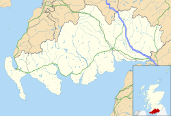
Location within Dumfries and Galloway
Population20 estimate
Council area
Lieutenancy area
Country Scotland
Sovereign state United Kingdom
Post town Stranraer
Postcode district DG9
Dialling code 01776-860
Police Scotland
Fire Scottish
Ambulance Scottish
UK Parliament
Scottish Parliament
List of places
UK
Scotland
54°46′43″N4°58′52″W / 54.778549°N 4.981072°W / 54.778549; -4.981072 Coordinates: 54°46′43″N4°58′52″W / 54.778549°N 4.981072°W / 54.778549; -4.981072

Clachanmore is a village in the South Rhins of Galloway near Ardwell in the south west of Scotland. It has also been known as Low Ardwell. [1]

The name of the village means 'big village' (Clachan Mòr, in Gaelic) and may derive from a stone circle that formerly stood there; [2] there are remains of a circular enclosure on Barrack Knowe near High Clachanmore farmhouse. [3]

The old schoolhouse at Clachanmore The old schoolhouse at Clachanmore, Ardwell. - geograph.org.uk - 75853.jpg
The old schoolhouse at Clachanmore

Clachanmore school is the most prominent building in the village. The building dates to 1831 [4] and was the school for Ardwell. There is a small schoolmaster's house next door. Until 2003 it was an art gallery; it is now a private house.
Related Research Articles

<span class="mw-page-title-main">Dumfries</span> Town in Dumfries and Galloway, Scotland

Dumfries is a market town and former royal burgh within the Dumfries and Galloway council area of Scotland. It is located near the mouth of the River Nith into the Solway Firth about 25 miles (40 km) by road from the Anglo-Scottish border and just 15 miles (24 km) away from Cumbria by air. Dumfries is the county town of the historic county of Dumfriesshire.

<span class="mw-page-title-main">Dumfries and Galloway</span> Council area of Scotland

Dumfries and Galloway is one of 32 unitary council areas of Scotland and is located in the western Southern Uplands. It covers the historic counties of Dumfriesshire, Kirkcudbrightshire, and Wigtownshire, the latter two of which are collectively known as Galloway. The administrative centre and largest settlement is the town of Dumfries. The second largest town is Stranraer, on the North Channel coast, some 57 miles (92 km) to the west of Dumfries.

<span class="mw-page-title-main">Stranraer</span> Town and sea port in Scotland

Stranraer, also known as The Toon, is a town in Dumfries and Galloway, Scotland. It is located in the historical parish of Inch in the historic county of Wigtownshire. It lies on the shores of Loch Ryan, on the northern side of the isthmus joining the Rhins of Galloway to the mainland. Stranraer is Dumfries and Galloway's second-largest town, with a population including the immediate surrounding area of nearly 13,000 inhabitants.

<span class="mw-page-title-main">Wigtownshire</span> Historic county in Scotland

Wigtownshire or the County of Wigtown is one of the historic counties of Scotland, covering an area in the south-west of the country. Until 1975, Wigtownshire was an administrative county used for local government. Since 1975 the area has formed part of Dumfries and Galloway for local government purposes. Wigtownshire continues to be used as a territory for land registration, being a registration county. The historic county is all within the slightly larger Wigtown Area, which is one of the lieutenancy areas of Scotland and was used in local government as the Wigtown District from 1975 to 1996.

<span class="mw-page-title-main">Rhins of Galloway</span> Peninsula in Scotland

The Rhins of Galloway, otherwise known as the Rhins of Wigtownshire, is a hammer-head peninsula in Dumfries and Galloway, Scotland. Stretching more than 25 miles from north to south, its southern tip is the Mull of Galloway, the southernmost point of Scotland.

<span class="mw-page-title-main">Annan, Dumfries and Galloway</span> Human settlement in Scotland

Annan is a town and former royal burgh in Dumfries and Galloway, south-west Scotland. Historically part of Dumfriesshire, its public buildings include Annan Academy, of which the writer Thomas Carlyle was a pupil, and a Georgian building now known as "Bridge House". Annan also features a Historic Resources Centre. In Port Street, some of the windows remain blocked up to avoid paying the window tax.

Ardwell is a village in the Scottish unitary council area of Dumfries and Galloway. It lies on the shores of Luce Bay in the southern part of the Rhins of Galloway. The A716 road to Drummore or the Mull of Galloway passes through the village. The only other street is Ardwell Park, a street of new houses.

<span class="mw-page-title-main">Clan McCulloch</span> Lowland Scottish clan

The origins of Clan MacCulloch are unknown, but there is a consensus that the family was one of the most ancient families of Galloway, Scotland, and a leading medieval family in that region. Despite the obscurity of the early history of the clan, the history and genealogies of the family are well documented in Walter Jameson McCulloch's History of the Galloway Families of McCulloch, which provides extensive footnotes for original Scottish charters, correspondence, and other primary source documentation. The latter provides family history for the following lines: Myretoun, Ardwell, Killasser, Torhouse, Drummorrell, Inshanks and Mule, Torhousekie, Cardiness, Barholm, Kirkclaugh, Auchengool, and Ardwall.

<span class="mw-page-title-main">Newton Wamphray</span> Human settlement in Scotland

Newton Wamphray is a village in Dumfries and Galloway. Wamphray is the name of the surrounding parish and of the Wamphray Water, which flows south-west through the Wamphray Glen to join the River Annan near the small village, or hamlet, of Newton.

Canonbie is a small village in Dumfriesshire within the local authority area of Dumfries and Galloway in Scotland, 6 miles south of Langholm and 2 miles north of the Anglo-Scottish border. It is on the A7 road from Carlisle to Edinburgh, and the River Esk flows through it. There are frequent references in older documents to it as Canobie.

A moot hill or mons placiti is a hill or mound historically used as an assembly or meeting place, as a moot hall is a meeting or assembly building, also traditionally to decide local issues. In early medieval Britain, such hills were used for "moots", meetings of local people to settle local business. Among other things, proclamations might be read; decisions might be taken; court cases might be settled at a moot. Although some moot hills were naturally occurring features or had been created long before as burial mounds, others were purpose-built.

Stoneykirk is an area and a village in the heart of the Rhins of Galloway, Wigtownshire, in the administrative council area of Dumfries and Galloway, Scotland nearly ten miles in length and three and a half miles in breadth, bounded on the east by the bay of Luce, and on the west by the Irish Channel, 5 miles (8.0 km) south of Stranraer.

<span class="mw-page-title-main">Crossmichael</span> Human settlement in Scotland

Crossmichael is a small village on the east side of Loch Ken in the historical county of Kirkcudbrightshire, about 4 miles (6.4 km) north of Castle Douglas in Scotland.

<span class="mw-page-title-main">Cargenbridge</span> Human settlement in Scotland

Cargenbridge is a village located in Dumfries and Galloway, United Kingdom southwest of Dumfries. It is in Troqueer parish, in the historic county of Kirkcudbrightshire.

<span class="mw-page-title-main">Troqueer</span> Human settlement in Scotland

Troqueer is a former village and a parish in the historic county of Kirkcudbrightshire in Dumfries and Galloway on the west side of the River Nith. The eastern-side was merged with Dumfries to the east in 1929, and today eastern Troqueer is a suburb of Dumfries.

<span class="mw-page-title-main">Inch, Dumfries and Galloway</span> Human settlement in Scotland

Inch is a civil parish in Dumfries and Galloway, southwest Scotland. It lies on the shore of Loch Ryan, in the traditional county of Wigtownshire.

<span class="mw-page-title-main">Doon Castle Broch</span>

Doon Castle Broch is an iron-age broch located in Dumfries and Galloway, Scotland.

Pict's Knowe is a henge monument in the parish of Troqueer, Dumfries and Galloway. It is one of a small group of henge monuments around Dumfries which includes Broadlea henge near Annan. Pict's Knowe is located 4 km SW of Dumfries on a small sandy bank in the peat covered valley of the Crooks Pow stream.

Broadlea henge is a Neolithic or Bronze Age monument in the parish of Middlebie, Dumfries and Galloway. It is one of very few henge monuments in southern Scotland. The only other well preserved site is the considerably smaller Pict's Knowe near Dumfries. While Pict's Knowe is a single entrance, Class I henge, Broadlea has two entrances, making it a Class II henge. It measures 50m by 45m inside its ditch, which is as wide as 10m. The banks have been flattened over time but still rise in parts to around four feet high.

<span class="mw-page-title-main">Stranraer and the Rhins (ward)</span>

Stranraer and the Rhins(Ward 1) is one of the twelve wards used to elect members of Dumfries and Galloway Council in Scotland. It elects four Councillors under the Single Transferable Vote system.

References

  1. Maria Trotter, ed. Saxon, Galloway Gossip Sixty Years Ago: Being a Series of Articles Illustrative of the Manners, Customs, and Peculiarities of the Aboriginal Picts of Galloway, Choppington, Northumberland: R. Trotter, 1877, OCLC 25797165, pp. 79-80.
  2. Clachanmore, Royal Commission on the Ancient and Historical Monuments of Scotland.
  3. Barrack Knowe, High Clachanmore Archived 2012-03-13 at the Wayback Machine at ScotlandsPlaces.
  4. Dumfries & Galloway: Summary of places of interest Archived 2010-05-08 at the Wayback Machine , CAST.

Sources