Dumfries and Galloway is one of the 32 unitary council areas of Scotland, located in the western part of the Southern Uplands. It is bordered by East Ayrshire, South Ayrshire, and South Lanarkshire to the north; Scottish Borders to the north-east; the English county of Cumbria, the Solway Firth, and the Irish Sea to the south, and the North Channel to the west. The administrative centre and largest settlement is the town of Dumfries. The second largest town is Stranraer, located 76 miles (122 km) to the west of Dumfries on the North Channel coast.

Biggar is a town, parish and former burgh in South Lanarkshire, Scotland, in the Southern Uplands near the River Clyde on the A702. The closest neighbouring towns are Lanark, Peebles and Carluke.

Wing, known in antiquated times as Wyng, is a village and civil parish in east Buckinghamshire, England. The village is on the main A418 road between Aylesbury and Leighton Buzzard. It is about 8 miles (13 km) north-east of Aylesbury, 3 miles (5 km) west of Leighton Buzzard, and 12 miles (19 km) south of Milton Keynes.
Whitchurch is a village and civil parish in the unitary authority area of Buckinghamshire, England. The village is on the A413 road about 4 miles (6.4 km) north of Aylesbury and 4.5 miles (7 km) south of Winslow. The 2011 Census recorded a parish population of 932.
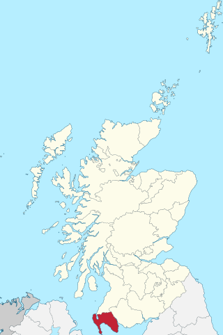
Wigtownshire or the County of Wigtown is one of the historic counties of Scotland, covering an area in the south-west of the country. Until 1975, Wigtownshire was an administrative county used for local government. Since 1975 the area has formed part of Dumfries and Galloway for local government purposes. Wigtownshire continues to be used as a territory for land registration, being a registration county. The historic county is all within the slightly larger Wigtown Area, which is one of the lieutenancy areas of Scotland and was used in local government as the Wigtown District from 1975 to 1996.

The Rhinsof Galloway is a double-headed peninsula in southwestern Scotland. It takes the form of a hammerhead projecting into the Irish Sea, terminating in the north at Corsewall and Milleur Points and in the south at the Mull of Galloway. It is connected to the rest of Wigtownshire by an isthmus, washed on the north by Loch Ryan and on the south by Luce Bay. From end to end, the peninsula measures 28 miles. It takes its name from the Gaelic word rinn, meaning "point".
Eaglesham is a village in East Renfrewshire, Scotland, situated about 10 miles (16 km) south of Glasgow, 3 miles (5 km) southeast of Newton Mearns and south of Clarkston, and 4 miles (6.4 km) southwest of East Kilbride.
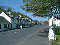
Drummore (drum-ORE; is the southernmost village in Scotland, located at the southern end of the Rhins of Galloway in Dumfries and Galloway: it has two satellite clachans, called Kirkmaiden and Damnaglaur.

Inverkip is a village and parish in the Inverclyde council area and historic county of Renfrewshire in the west central Lowlands of Scotland, 5 miles (8 km) southwest of Greenock and 8.1 miles (13 km) north of Largs on the A78 trunk road. The village takes its name from the River Kip and is served by Inverkip railway station.

Carnwath is a moorland village on the southern edge of the Pentland Hills of South Lanarkshire, Scotland. The village lies about 30 mi (50 km) south of both Edinburgh and Glasgow. It is bounded by the North Medwyn and South Medwyn watercourses.

Pleshey is a historic village and civil parish in the Chelmsford district, in the county of Essex, England, 6 miles (10 km) north-west of Chelmsford. The Normans built a motte-and-bailey castle in the late 11th century; the motte is one of the largest of its kind in Great Britain. It was besieged several times during the Barons' Wars and rebellions in the 13th century.
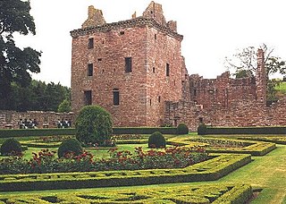
Edzell Castle is a ruined 16th-century castle, with an early-17th-century walled garden. It is located close to Edzell, and is around 5 miles (8 km) north of Brechin, in Angus, Scotland. Edzell Castle was begun around 1520 by David Lindsay, 9th Earl of Crawford, and expanded by his son, Sir David Lindsay, Lord Edzell, who also laid out the garden in 1604. The castle saw little military action, and was, in its design, construction and use, more of a country house than a defensive structure. It was briefly occupied by English troops during Oliver Cromwell's invasion of Scotland in 1651. In 1715 it was sold by the Lindsay family, and eventually came into the ownership of the Earl of Dalhousie. It was given into state care in the 1930s, and is now a visitor attraction run by Historic Environment Scotland. The castle consists of the original tower house and building ranges around a courtyard. The adjacent Renaissance walled garden, incorporating intricate relief carvings, is unique in Scotland. It was replanted in the 1930s, and is considered to have links to esoteric traditions, including Rosicrucianism and Freemasonry.
Ardwell is a village in the Scottish unitary council area of Dumfries and Galloway. It lies on the shores of Luce Bay in the southern part of the Rhins of Galloway. The A716 road to Drummore or the Mull of Galloway passes through the village. The only other street is Ardwell Park, a street of new houses.

Stonehouse is a rural village in South Lanarkshire, Scotland. It is on Avon Water in an area of natural beauty and historical interest, near to the Clyde Valley. It is on the A71 trunk road between Edinburgh and Kilmarnock, near the towns of Hamilton, Larkhall and Strathaven. The population of Stonehouse is around 7,500.

Pleshey Castle is a man-made motte and bailey castle in Pleshey in Essex, England. It was built in the 11th century and it is one of the best preserved motte and bailey castles in England.
Kirkmaiden is a parish in the Rhins of Galloway, the most southerly in Scotland; the present Church of Scotland parish has the same name as and is approximately coterminous with the original pre-Reformation parish.

Kirkcowan is an area about 15 miles in length, and from nearly two to nearly seven miles in breadth, comprising 30,580 acres, of which 7000 are arable, 300 woodland and plantations, and the remainder meadow, pasture in Machars, in the historical county of Wigtownshire, in Dumfries and Galloway, Scotland, with the village of Kirkcowan, bounded on the east by the river Bladnoch, on the west by the river Tarff, and is 6 miles W. by S.W. from Newton Stewart.
Stoneykirk is an area and a village in the heart of the Rhins of Galloway, Wigtownshire, in the administrative council area of Dumfries and Galloway, Scotland nearly 10 miles (16 km) in length and 3+1⁄2 miles (5.6 km) in breadth, bounded on the east by the bay of Luce, and on the west by the Irish Channel, 5 miles (8 km) south of Stranraer.

Kirkandrews, sometimes written as Kirkanders in older documents, is a coastal hamlet about 9 kilometres (6 mi) west-southwest of Kirkcudbright in Dumfries and Galloway, Scotland. It sits in farmland at the head of Kirkandrews Bay, an inlet of Wigtown Bay.