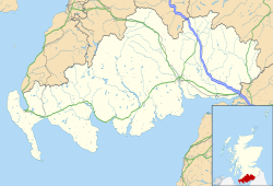
Port Logan

Last updated

Port Logan
Dumfries and Galloway UK location map.svg
Red pog.svg
Port Logan
Location within Dumfries and Galloway
OS grid reference NX097405
  Edinburgh 110 mi (177 km)
  London 299 mi (481 km)
Council area
Lieutenancy area
Country Scotland
Sovereign state United Kingdom
Post town Stranraer
Postcode district DG9
Police Scotland
Fire Scottish
Ambulance Scottish
UK Parliament
Scottish Parliament
List of places
UK
Scotland
54°43′23″N4°57′23″W / 54.72315°N 4.95644°W / 54.72315; -4.95644 Coordinates: 54°43′23″N4°57′23″W / 54.72315°N 4.95644°W / 54.72315; -4.95644
View over the harbour of Port Logan out into the Irish Sea: Telford's bell tower is clearly visible Port Logan sunset.jpg
View over the harbour of Port Logan out into the Irish Sea: Telford's bell tower is clearly visible

Port Logan, formerly Port Nessock, is a small village in the parish of Kirkmaiden in the Rhins of Galloway in Wigtownshire. The Gaelic name is Port Neasaig.

Contents

Port Nessock Bay is now all that remains of the western end of a strait that in post-glacial times separated the main part of what is now the Rinns of Galloway from three smaller islands to its south. [1] There was a ruined pier in the bay in 1790, at which time kelp and samphire were gathered on the coast to the south. [2]

The village was planned; it was created by Colonel Andrew MacDowall (Douall), the laird of Logan, in 1818. MacDowall erected a quay and bell tower designed by Thomas Telford, and a causewayed road leading to them. This causeway blocked the view to seaward of the existing houses on the Lower Road (Laigh Row), whose inhabitants MacDowall expected to move to a new Upper Road; in the event, they welcomed the shelter it provided from the brisk onshore winds, and preferred to stay put, though subsequently most of them added a second storey so recovering some of the sea view.

Character and facilities

Facilities include a village hall which used to be the local Lifeboat Station. It is run by a local committee and completely self-funding. In recent years it has been used for a range of social events such as weddings and to celebrate Hogmanay and St Andrew's Night. It is sometimes used for meetings of the Kirkmaiden Community Council. [3] There is a tiny part-time post office, as well as a small market garden supplying local businesses and the public.

For a couple of years until 2006 they also included a newly built cafe with excellent views called the Butterchurn; however, this was then closed, and converted into a private house.

Tourist attractions

The Logan Fish Pond, Logan Botanic Garden & Logan House Garden are nearby. Logan Fish Pond was also built by Colonel Andrew McDouall, originally as a fish larder for Logan House, circa 1788 and completed around 1800, with a Keeper's Cottage and Bathing Hut which still stand as part of the modern Logan Fishpond Marine Life Centre. 2016, the Fishpond - the oldest natural marine aquarium in the UK, if not the world - is still a tourist attraction, opened again under new management. The story of Logan Fishpond can be found at the website of Historic Scotland.

Media associations

The village was used between 2001 and 2003 as the setting for a popular BBC series, Two Thousand Acres of Sky starring actress Michelle Collins.

2017 saw the filming of The Vanishing starring Gerard Butler, Peter Mullan and newcomer Connor Swindells. [4]

USAAF Douglas C-47 crash

On 27 July 1944, two Douglas C-47 Skytrains (one was serial number 42-93038) of the United States Army Air Forces were on a flight from Filton to a stop at Prestwick before flying on to the United States. The flight was transporting wounded soldiers. The flight encountered bad weather, and the pilot of 42-93038 tried to gain altitude to clear the cliffs. The C-47 crashed into the cliff side at Port Logan, where all 22 passengers and crew died. [5]

Related Research Articles

Wigtown Human settlement in Scotland

Wigtown is a town and former royal burgh in Wigtownshire, of which it is the county town, within the Dumfries and Galloway region in Scotland. It lies east of Stranraer and south of Newton Stewart. It is known as "Scotland's National Book Town" with a high concentration of second-hand book shops and an annual book festival.

Stranraer Town and sea port in Scotland

Stranraer, also known as The Toon, is a town in Dumfries and Galloway, Scotland. It is located in the historical parish of Inch in the historic county of Wigtownshire. It lies on the shores of Loch Ryan, on the northern side of the isthmus joining the Rhins of Galloway to the mainland. Stranraer is Dumfries and Galloway's second-largest town, with a population including the immediate surrounding area of nearly 13,000 inhabitants.

Eyemouth Coastal town in Berwickshire Scotland

Eyemouth is a small town and civil parish in Berwickshire, in the Scottish Borders area of Scotland. It is two miles east of the main north–south A1 road and just eight miles north of Berwick-upon-Tweed. It has a population of about 3,420 people (2004).

Isle of Whithorn Human settlement in Scotland

Isle of Whithorn is one of the most southerly villages and seaports in Scotland, lying on the coast north east of Burrow Head, about three miles from Whithorn and about thirteen miles south of Wigtown in Dumfries and Galloway. Whithorn,, is a former royal burgh in Wigtownshire, Dumfries and Galloway, with which Isle of Whithorn is frequently incorrectly amalgamated or confused. It is referred to locally as 'The Isle' - never 'the Isle of Whithorn'.

Wigtownshire Historic county in Scotland

Wigtownshire or the County of Wigtown is a historic county, registration county and lieutenancy area in south-west Scotland. It is popularly known as and referred to as The Shire. Until 1975, Wigtownshire was one of the administrative counties used for local government purposes, and is now administered as part of the council area of Dumfries and Galloway. As a lieutenancy area, Wigtownshire has its own Lord Lieutenant, currently John Alexander Ross. In the 19th century, it was also called West Galloway. The county town was historically Wigtown, with the administrative centre moving to Stranraer, the largest town, on the creation of a county council in 1890.

Logan Botanic Garden

Logan Botanic Garden is a botanical garden located near Port Logan on the Rhins of Galloway, at the south-western tip of Scotland.

Rhins of Galloway Peninsula in Scotland

The Rhins of Galloway, otherwise known as the Rhins of Wigtownshire, is a hammer-head peninsula in Dumfries and Galloway, Scotland. Stretching more than 25 miles from north to south, its southern tip is the Mull of Galloway, the southernmost point of Scotland.

Fishponds Human settlement in England

Fishponds is a large suburb in the north-east of the English city of Bristol, about 3 miles (5 km) from the city centre. It has two large Victorian-era parks: Eastville Park and Vassall's Park. The River Frome runs through both with the Frome Valley Walkway alongside it. A restored mill found at Snuff Mills near the Vassall's Park end of the river has kept its original waterwheel, which can still be seen and heard turning. Eastville Park has a large boating lake with central wildlife reserves. Fishponds is mainly residential. Two main bus routes pass through. Housing is typically terraced Victorian. The high street shops include an international supermarket, Asian food store, charity shops, takeaways and Lidl, Aldi and Morrisons supermarkets. It has a small student population from the presence of the Glenside campus of the University of the West of England. The name Fishponds derives from when it was a quarry district, like nearby Soundwell. The empty quarries became large fishponds, which have since been filled in. One remained until the mid-1970s, when it was officially closed: a popular swimming area named "The Lido" by locals. It now belongs to an angling club.

Drummore Human settlement in Scotland

Drummore (drum-ORE; is the southernmost village in Scotland, located at the southern end of the Rhins of Galloway in Dumfries and Galloway: it has two satellite clachans, called Kirkmaiden and Damnaglaur.

Ardwell Human settlement in Scotland

Ardwell is a village in the Scottish unitary council area of Dumfries and Galloway. It lies on the shores of Luce Bay in the southern part of the Rhins of Galloway. The A716 road to Drummore or the Mull of Galloway passes through the village. The only other street is Ardwell Park, a street of new houses.

Langbank Human settlement in Scotland

Langbank is a village on the south bank of the River Clyde in Renfrewshire, Scotland. The name is thought to come from ‘long bank’. It is 9.3 miles/15 km northwest from Paisley (Renfrewshire) and 3.4 miles/5.5 km east from Port Glasgow (Inverclyde) on the A8.

Port de Grave is a peninsula on Conception Bay (CB) in Newfoundland and Labrador, Canada. The peninsula contains the communities of Bareneed, Black Duck Pond, Otterbury, Ship Cove, Blow Me Down, Hibb's Cove, Pick Eyes, and Hussey's Cove with a population of approximately 975 (2006). This community is located in the provincial electoral district of Port de Grave. An unincorporated area, for statistics purposes it is called Division No. 1, Subdivision L. The Peninsula is accessible by road via Route 72.

Clan MacDowall Lowland Scottish clan

Clan MacDowall is a Lowlands Scottish clan.

Sorbie Human settlement in Scotland

Sorbie is a small village in Wigtownshire, Machars, within the Administration area of Dumfries and Galloway Council, Scotland.

Glasserton Human settlement in Scotland

Glasserton is a civil parish in Dumfries and Galloway, south-west Scotland. It is on the Machars peninsula, in the traditional county of Wigtownshire. The parish is about 8 miles (13 km) in length, varying in breadth from 1 to 3 miles, and contains 13,477 acres (54.54 km2).

Kirkmaiden Human settlement in Scotland

Kirkmaiden is a parish in the Rhins of Galloway, the most southerly in Scotland; the present Church of Scotland parish has the same name as and is approximately coterminous with the original pre-Reformation parish.

Stoneykirk Human settlement in Scotland

Stoneykirk is an area and a village in the heart of the Rhins of Galloway, Wigtownshire, in the administrative council area of Dumfries and Galloway, Scotland nearly ten miles in length and three and a half miles in breadth, bounded on the east by the bay of Luce, and on the west by the Irish Channel, 5 miles (8.0 km) south of Stranraer.

Bankton House

Bankton House is a late 17th-century house situated south of Prestonpans in East Lothian, Scotland. The house is located between the A1 road and the East Coast Main Line railway at grid reference NT394736.

Waikoloa Beach

Waikoloa Beach is an area located on the South Kohala coast on the island of Hawaii and is located in the census-designated place of Puako. It can be confused for Waikoloa Village, a CDP in the same "ahupuaʻa" and is also known as "Waikoloa".

Kirkcolm Human settlement in Scotland

Kirkcolm is a village and civil parish on the northern tip of the Rhinns of Galloway peninsula, south-west Scotland. It is in Dumfries and Galloway, and is part of the former county of Wigtownshire. The parish is bounded on the north and west by the sea, on the east by the bay of Loch Ryan and on the south by Leswalt parish.

References

  1. Whittow, J B (1977). Geology and Scenery in Scotland. Harmondsworth: Penguin Books. p. 63. ISBN   0-14-021867-X. OCLC   3690635.
  2. Statistical Account of Scotland , vol 5, page 429; republished 1983
  3. "Community Councils". Archived from the original on 26 August 2012.
  4. "Gerard Butler's lighthouse mystery movie hits the big screen". www.bbc.co.uk/news. 29 March 2019. Retrieved 29 March 2019.
  5. Aviation Safety Network 19440727-0