
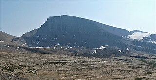
Mount Ball is a mountain located on the Continental Divide, on the borders of Banff and Kootenay national parks in Western Canada. Mt. Ball is the highest peak of the Ball Range in the Canadian Rockies.

Glacier National Park is part of a system of 43 parks and park reserves across Canada, and one of seven national parks in British Columbia. Established in 1886, the park encompasses 1,349 km2 (521 sq mi), and includes a portion of the Selkirk Mountains, which are part of the larger grouping of mountains, the Columbia Mountains. It also contains the Rogers Pass National Historic Site.

The Columbia Mountains are a group of mountain ranges along the Upper Columbia River in British Columbia, Montana, Idaho and Washington. The mountain range covers 135,952 km². The range is bounded by the Rocky Mountain Trench on the east, and the Kootenai River on the south; their western boundary is the edge of the Interior Plateau. Seventy-five percent of the range is located in Canada and the remaining twenty-five percent in the United States; American geographic classifications place the Columbia Mountains as part of the Rocky Mountains complex, but this designation does not apply in Canada. Mount Sir Sandford is the highest mountain in the range, reaching 3,519 metres (11,545 ft).

Mount Balfour is a mountain located on the Continental Divide, part of the border between British Columbia and Alberta, in the Waputik Range in the Park Ranges of the Canadian Rockies. It is the 71st highest peak in Alberta and the 113th highest in British Columbia; it is also the 52nd most prominent in Alberta.
Mistaya Mountain is located on the border of Alberta and British Columbia, on the Continental Divide. It was named in 1918. Mistaya is either the Cree name for "grizzly bear" or is the Stoney word for "much wind".

Mount Habel is a 3,073-metre (10,082-foot) mountain summit located in Banff National Park on the Continental Divide along the border of Alberta and British Columbia in the Waputik Mountains, part of the Canadian Rockies. It was named in 1986 after Jean Habel. Jean Habel was a German geographer who explored the Canadian Rockies and in 1897 was the first to set foot on the Wapta Icefield which surrounds Mount Habel.

Mount Biddle is a mountain in British Columbia, Canada.

Avalanche Mountain is a 2,861-metre (9,386-foot) summit in Glacier National Park in the Selkirk Mountains in British Columbia, Canada. Its nearest higher peak is Mount Macdonald, 2.2 km (1.4 mi) to the north. Mount Sir Donald is 3.83 km (2.38 mi) to the southeast, and Eagle Peak is 1.46 km (0.91 mi) to the south-southeast. The Avalanche Glacier is situated on the east side of the peak, and the Connaught Tunnel lies partially beneath Avalanche Mountain. The peak is visible from eastbound Highway 1, the Trans-Canada Highway approaching Rogers Pass. During winter and spring of each year the western slope, named Avalanche Crest, generates avalanches which can threaten the highway.

Trolltinder Mountain is a 2,912-metre (9,554-foot) mountain summit located immediately west of the Continental Divide, in the Waputik Range of the Canadian Rockies in British Columbia, Canada. It is situated in Yoho National Park, with its nearest higher peak being Mount Balfour, 1.0 km (0.62 mi) to the northeast, and Fairy Lake directly below its southern slope.
Mount Tilley is a 2,649-metre (8,691-foot) mountain summit located in the Gold Range of the Monashee Mountains in British Columbia, Canada. Situated west of the Columbia River and Upper Arrow Lake, this peak is visible from the Trans-Canada Highway, Revelstoke, and Revelstoke Mountain Resort ski area. Its nearest higher peak is Mount Begbie, 3 km (1.9 mi) to the east, with Tilley Lake set in the saddle between the two peaks.

Mount King George is a prominent 3,413-metre (11,198-foot) mountain summit located in Height of the Rockies Provincial Park, in the Canadian Rockies of British Columbia, Canada. The mountain is the highest point of The Royal Group, a subset of the Rockies, which includes Mount Queen Mary, Mount Princess Mary, Mount Prince George, Mount Prince Albert, Mount Prince Henry, Mount Prince John, and Mount Prince Edward. Its nearest higher peak is Mount Joffre, 16.0 km (9.9 mi) to the east. Mount King George is composed of sedimentary rock laid down during the Cambrian period. Formed in shallow seas, this sedimentary rock was pushed east and over the top of younger rock during the Laramide orogeny.
Mount Onderdonk is a mountain in British Columbia named for Andrew Onderdonk. It is located in the northern Selkirk Mountains between lower Revelstoke Lake and the Wood Arm of Kinbasket Lake. The mountain is 280 miles from Vancouver, 1861 miles from Toronto and 2047 miles from Montreal. Andrew Onderdonk was a Dutch-American engineer who worked in the late 1800s building the Canadian Pacific Railway in British Columbia and in other locations. William Lowell Putnam and Roger W. Laurilla gave the mountain this name as a tribute to Onderdonk.

St. Julien Mountain is a 3,090-metre (10,138 ft) mountain summit located in the Canadian Rockies of British Columbia, Canada. It is situated on the British Columbia-Alberta border, as well as the Continental Divide, and the west boundary of Banff National Park. Neighbors include Mount Forbes 6.4 km (4.0 mi) to the east-northeast, Valenciennes Mountain 2.8 km (1.7 mi) to the south, and Icefall Peak is 12 km (7.5 mi) to the west.
Albert Peak is a 3,045-metre (9,990-foot) mountain summit located in British Columbia, Canada.

Mount Cartier is a 2,610-metre (8,563-foot) mountain summit located in British Columbia, Canada.

Downie Peak is a 2,926-metre (9,600 ft) mountain summit located in British Columbia, Canada.
Mount Conrad is a 3,279-metre (10,758-foot) mountain summit in British Columbia, Canada.

Mount Duchesnay is a 2,927-metre (9,603-foot) summit in British Columbia, Canada.

Mount English is a 2,680-metre (8,793-foot) mountain summit located in the Gold Range of the Monashee Mountains of British Columbia, Canada. Situated 17 km (11 mi) southwest of Revelstoke, this peak is visible from the Trans-Canada Highway and Revelstoke Mountain Resort ski slopes. Neighbors include Mount Macpherson 8 km (5.0 mi) to the northeast, Mount Tilley 5 km (3.1 mi) to the east, and Mount Begbie is 8 km (5.0 mi) to the east. Precipitation runoff from Mount English drains into tributaries of the Eagle River. Topographic relief is significant as the summit rises 1,540 meters (5,052 ft) above Wap Creek in 3 km (1.9 mi).

Catamount Peak is a 2,733-metre (8,967-foot) mountain located in Glacier National Park in British Columbia, Canada. Catamount Peak is part of the Hermit Range of the Selkirk Mountains and is 7 km (4.3 mi) west of Rogers Pass. It is approximately midway between Revelstoke and Golden. Neighbors include Cheops Mountain, 5.05 km (3.14 mi) to the east, and Ursus Major Mountain, 1.83 km (1.14 mi) to the northeast. Precipitation runoff from the mountain's south slope drains to Illecillewaet River via Cougar Brook, and the north slope drains to the Beaver River via Ursus Creek. Topographic relief is significant as the summit rises 1,230 metres (4,035 ft) above Ursus Creek in 2 km (1.2 mi) and 930 m (3,051 ft) above Cougar Brook in 1 km (0.62 mi). This peak is visible from the Trans-Canada Highway.

