Howser Spire

Last updated
Howser Spire, The Bugaboos
Howser Spire 1.jpg
Highest point
Elevation 3,412 m (11,194 ft)
Prominence 1,299 m (4,262 ft)
Listing
Coordinates 50°43′47″N116°48′48″W / 50.72972°N 116.81333°W / 50.72972; -116.81333 (Howser Spire)
Geography
District Kootenay Land District
Parent range Purcell Mountains, East Kootenay
Topo map NTS 82K10 Howser Creek
Geology
Mountain type Granite
Climbing
First ascent 1916
Conrad Kain
Albert MacCarthy
E. MacCarthy
J. Vincent
Henry Frind

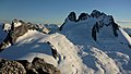
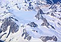
Howser Spire, or Howser Spire Massif, is a group of three distinct granite peaks, and the highest mountain of the Canadian Bugaboo Spires. The mountain is located at the southwest corner of the Vowell Glacier, within the Bugaboo mountain range in the Purcell Mountains, a subrange of British Columbia's Columbia Mountains, The highest of the three spires is the North Tower at 3,412 m (11,194 ft), the Central Tower the lowest, and the South Tower is slightly lower than the North at 3,292 m (10,801 ft). [1]

Contents

Under the spire Howser Spire - under the spire.jpg
Under the spire

Howser Spire is named after the town of Howser on Duncan Lake and Howser Creek. [2]

The first ascent of the North Tower was made in August 1916 by Conrad Kain, Albert MacCarthy, E. MacCarthy, J. Vincent and Henry Frind. [2] [3]

The Beckey-Chouinard/West Buttress route is recognized in the historic climbing text Fifty Classic Climbs of North America and considered a classic around the world. [4]

Nearby

Related Research Articles

Fred Beckey American rock climber and mountaineer

Friedrich Wolfgang Beckey, known as Fred Beckey, was an American rock climber, mountaineer and book author, who in seven decades of climbing achieved hundreds of first ascents of tallest peaks and best routes in remote corners of Alaska, the Canadian Rockies and the Pacific Northwest. Among Fifty Classic Climbs of North America, seven were established by Beckey, often climbing with some of the best known climbers of each generation.

Mount Robson Mountain in British Columbia, Canada

Mount Robson is the most prominent mountain in North America's Rocky Mountain range; it is also the highest point in the Canadian Rockies. The mountain is located entirely within Mount Robson Provincial Park of British Columbia, and is part of the Rainbow Range. Mount Robson is the second highest peak entirely in British Columbia, behind Mount Waddington in the Coast Range. The south face of Mount Robson is clearly visible from the Yellowhead Highway, and is commonly photographed along this route.

Conrad Kain

Conrad Kain was an Austrian mountain guide who guided extensively in Europe, Canada, and New Zealand, and was responsible for the first ascents of more than 60 routes in British Columbia. He is particularly known for pioneering climbs in the Purcell Mountains and the first ascents of Mount Robson (1913), Mount Louis (1916) and Bugaboo Spire (1916).

The Bugaboos

The Bugaboos are a mountain range in the Purcell Mountains of eastern British Columbia, Canada. The granite spires of the group are a popular mountaineering destination. The Bugaboos are protected within Bugaboo Provincial Park.

Purcell Mountains Mountain range in British Columbia, Canada

The Purcell Mountains are a mountain range in southeastern British Columbia, Canada. They are a subrange of the Columbia Mountains, which includes the Selkirk, Monashee, and Cariboo Mountains. They are located on the west side of the Rocky Mountain Trench in the area of the Columbia Valley, and on the east side of the valley of Kootenay Lake and the Duncan River. The only large settlements in the mountains are the Panorama Ski Resort and Kicking Horse Resort, adjacent to the Columbia Valley towns of Invermere and Golden, though there are small settlements, such as Yahk and Moyie along the Crowsnest Highway, and residential rural areas dependent on the cities of Creston, Kimberley and Cranbrook, which are located adjacent to the range.

Columbia Mountains

The Columbia Mountains are a group of mountain ranges along the upper Columbia River in British Columbia, Montana, Idaho and Washington. The mountain range covers 135,952 km². The range is bounded by the Rocky Mountain Trench on the east, and the Kootenai River on the south; their western boundary is the edge of the Interior Plateau. Seventy-five percent of the range is located in Canada and the remaining twenty-five percent in the United States; American geographic classifications place the Columbia Mountains as part of the Rocky Mountains complex, but this designation does not apply in Canada. Mount Sir Sandford is the highest mountain in the range, reaching 3,519 metres (11,545 ft).

Slesse Mountain

Slesse Mountain, usually referred to as Mount Slesse, is a mountain just north of the US-Canada border, in the Cascade Mountains of British Columbia, near the town of Chilliwack. It is notable for its large, steep local relief. For example, its west face drops over 1,950 m (6,398 ft) to Slesse Creek in less than 3 km (2 mi). It is also famous for its huge Northeast Buttress; see the climbing notes below. The name means "fang" in the Halkomelem language. Notable nearby mountains include Mount Rexford and Canadian Border Peak in British Columbia, and American Border Peak, Mount Shuksan, and Mount Baker, all in the US state of Washington.

Conrad Kain Hut Mountain hut in Canada

The Conrad Kain hut is an alpine hut located in Bugaboo Provincial Park in British Columbia. The hut is maintained by the Alpine Club of Canada. Coordinates: 50°44′18″N116°45′48″W NAD27 11U 516700 5620754

Snowpatch Spire

With its first ascent in 1940, Snowpatch Spire mountain peak was the last of the Bugaboo Spires to be climbed. It is located South-West of the Conrad Kain hut, across the Crescent Glacier.

Bugaboo Spire

Perhaps the most impressive peak in the Bugaboos, Bugaboo Spire sits between the Vowell and Crescent glaciers, just under 2 km West of the ACC's Conrad Kain hut. It has some of the most spectacular alpine climbing in Canada.

<i>Fifty Classic Climbs of North America</i>

Fifty Classic Climbs of North America is a climbing guidebook and history written by Steve Roper and Allen Steck. It is considered a classic piece of climbing literature, known to many climbers as simply "The Book", and has served as an inspiration for more recent climbing books, such as Mark Kroese's Fifty Favorite Climbs. Though much of the book's contents are now out of date, it is still recognized as a definitive text which goes beyond the traditional guidebook.

East Face (Mount Whitney)

The East Face of Mount Whitney is a technical alpine rock climbing route and is featured in Fifty Classic Climbs of North America. Mount Whitney is the highest peak in the contiguous United States.

Petit Grepon

Petit Grepon is a semi-detached spire in Colorado's Rocky Mountain National Park. It is one of the "Cathedral Spires" which also includes Sharkstooth, The Saber, and The Foil. The South Face route of Petit Grepon is recognized in the historic climbing text Fifty Classic Climbs of North America and considered a classic around the world.

Cirque of the Unclimbables

Cirque of the Unclimbables, located inside the Nahanni National Park Reserve, in the Northwest Territories, Canada, approximately 500 km (311 mi) west of Yellowknife, is a cluster of peaks and walls in the Mackenzie Mountains Natural Region.

Robert L. M. Underhill

Robert Lindley Murray Underhill was an American mountaineer best known for introducing modern Alpine style rope and belaying techniques to the U.S. climbing community in the late 1920s and early 1930s.

Resplendent Mountain Mountain in BC, Canada

Resplendent Mountain, or Mount Resplendent is a peak in the Canadian Rockies, located within Mount Robson Provincial Park in British Columbia, Canada. It is a part of the Rainbow Range, and is a sister peak to the more famous Mount Robson, its nearest neighbour. Together they form a classic panorama seen by travellers from the VIA railway and Highway 16. The mountain was named by Arthur P. Coleman, and A.O. Wheeler wrote, "On the east side it is clad from top to bottom in pure white snow, and presents with the sun shining upon it a spectacle of such wonderful brilliance that the aptness of the name became immediately apparent." The first ascent was achieved on the same historic 1911 trip in which Conrad Kain first scouted the climbing routes later to be used on the first ascent of Mount Robson.

Peter Kaufmann-Bohren Swiss alpinist (b. 1886, d. 1971)

Peter Kaufmann-Bohren was a Swiss ski instructor and mountain guide, climbing in the Swiss Alps and the Canadian Rockies.

Karnak Mountain

Karnak Mountain is a 3,411-metre (11,191 ft) mountain summit located 42 km (26 mi) west-southwest of Invermere in the Purcell Mountains of southeast British Columbia, Canada. The nearest higher peak is Jumbo Mountain, 0.79 km (0.49 mi) to the east-northeast, and The Lieutenants is set 2 km (1.2 mi) to the northwest. Karnak and Jumbo form a double summit massif which is the second-highest mountain in the Purcells. The first ascent of Karnak Mountain was made August 14, 1915, by A.H. & E.L. MacCarthy, M. & W.E. Stone, and Conrad Kain via the southwest slopes. The peak was named in 1910 by Stone and MacCarthy after Karnak, the Egyptian Temple Complex. The mountain's name was officially adopted June 9, 1960, when approved by the Geographical Names Board of Canada.

Jumbo Mountain (Canada)

Jumbo Mountain, sometimes called Mount Jumbo, is a 3,437 meter elevation mountain summit located 42 km (26 mi) west-southwest of Invermere in the Purcell Mountains of southeast British Columbia, Canada. The nearest higher peak is Mount Farnham, 11 km (6.8 mi) to the north-northeast, and Karnak Mountain is set 0.79 km (0.49 mi) to the west. Jumbo and Karnak form a double summit massif which is the second-highest mountain in the Purcells, and fourth-highest in the Columbia Mountains. The first ascent of Jumbo Mountain was made August 4, 1915, by H.O. Frind, A.H. & E.L. MacCarthy, M & W.E. Stone, B. Shultz, and Conrad Kain via the North/Northeast Slopes. The peak was named by Edward Warren Harnden after the 1892 Jumbo Mineral Claim on nearby Toby Creek, which in turn was named for Jumbo the elephant. The mountain's name was officially adopted March 31, 1924, when approved by the Geographical Names Board of Canada. Based on the Köppen climate classification, Jumbo Mountain is located in a subarctic climate zone with cold, snowy winters, and mild summers. Temperatures can drop below −20 °C with wind chill factors below −30 °C. Precipitation runoff from the mountain drains into south into Jumbo Creek which is a tributary of Toby Creek, and meltwater from the Jumbo Glacier on its north slope drains into Horsethief Creek which, like Toby Creek, is also a tributary of the Columbia River.

Commander Mountain

Commander Mountain is a 3,371-metre (11,060 ft) glaciated mountain summit located 42 km (26 mi) west-southwest of Invermere in the Purcell Mountains of southeast British Columbia, Canada. It is the seventh-highest mountain in the Purcells. The nearest higher peak is Jumbo Mountain, 2 km (1.2 mi) to the south, and The Lieutenants is set 2.12 km (1.32 mi) to the west. The first ascent of Commander Mountain was made August 4, 1915, by A.H. & E.L. MacCarthy, M. & W.E. Stone, B. Shultz, and Conrad Kain via the north ridge. The peak was named in 1915 by Winthrop E. Stone, member of the first ascent party.

References

  1. "Howser Spire". SummitPost.org. Retrieved July 14, 2009.
  2. 1 2 "Howser Spire". Bivouac.com. Retrieved July 14, 2009.
  3. Mountaineers Books 2nd edition., 2003, Randall Green, Joe Bensen., ISBN   0-89886-795-9, ISBN   978-0-89886-795-4
  4. Roper, Steve; Steck, Allen (1979). Fifty Classic Climbs of North America . San Francisco: Sierra Club Books. pp. 60–64. ISBN   0-87156-292-8.