| Snowpatch Spire | |
|---|---|
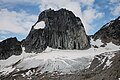
 Snowpatch Spire, with Pigeon Spire in the background on the right, Hound's Tooth and Marmolata Spire on the left. | |
| Highest point | |
| Elevation | 3,084 m (10,118 ft) [1] |
| Prominence | 284 m (932 ft) [2] |
| Parent peak | Howser Spire (3,412 m) [2] |
| Coordinates | 50°44′11″N116°46′56″W / 50.73639°N 116.78222°W [3] |
| Geography | |
 Snowpatch Spire Location in British Columbia | |
 | |
| Interactive map of Snowpatch Spire | |
| Country | Canada |
| Province | British Columbia |
| District | Kootenay Land District |
| Protected area | Bugaboo Provincial Park |
| Parent range | Purcell Mountains The Bugaboos |
| Topo map | NTS 82K10 Howser Creek |
| Geology | |
| Rock age | 135 Million years ago [4] |
| Rock type | Granodiorite [4] |
| Climbing | |
| First ascent | August 1940 by Raffi Bedayan and Jack Arnold [5] |
| Easiest route | class 5.8 [6] |
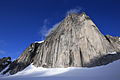
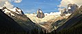
Snowpatch Spire is a mountain peak in British Columbia, Canada. With its first ascent in 1940, it was the last of the Bugaboo Spires to be climbed. [2] It is located southwest of the Conrad Kain hut, between Bugaboo, Vowell and Crescent Glaciers, at the south end of Bugaboo Provincial Park. [7] The mountain's toponym was officially adopted October 29, 1962, by the Geographical Names Board of Canada. [3]