Related Research Articles

Licking County is a county located in the central portion of the U.S. state of Ohio. At the 2020 census, the population was 178,519. Its county seat is Newark. The county was formed on January 30, 1808, from portions of Fairfield County.

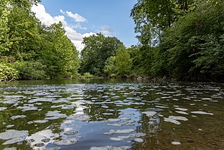
The Licking River is a tributary of the Muskingum River, about 40 mi (65 km) long, in central Ohio in the United States. Via the Muskingum and Ohio Rivers, it is part of the watershed of the Mississippi River.
Blacklick Creek is a tributary stream of Big Walnut Creek in Ohio, flowing through Licking, Fairfield and Franklin counties. The creek's name was originally given by Native Americans, who had noticed the animals that frequented the creek to lick its black-colored salt stones. It has also been known as Black Lick Creek, Black Lick Fork, Blacks Lick Creek, and Big Lick Creek.
Boston is an unincorporated community in Licking County, in the U.S. state of Ohio.
Amsterdam is an unincorporated community in Licking County, in the U.S. state of Ohio.
Appleton is an unincorporated community in Licking County, in the U.S. state of Ohio.
Toboso is an unincorporated community in Licking County, in the U.S. state of Ohio.
Central City is a ghost town in Licking County, in the U.S. state of Ohio. It was located on the intersection of the Toledo and Ohio Central Railway and the Central Ohio Railroad at the northern edge of what's now the city of Heath.

Chatham is an unincorporated community in Licking County, in the U.S. state of Ohio.
Columbia Center is a historic neighborhood of the city of Pataskala in Licking County, Ohio, United States. It lies slightly more than 1 mile (1.6 km) west of Pataskala's downtown.
Fredonia is an unincorporated community in Licking County, in the U.S. state of Ohio.
Moscow is a ghost town in Licking County, in the U.S. state of Ohio.
New Way is an unincorporated community in Licking County, in the U.S. state of Ohio.

Perryton is an unincorporated community in Licking County, in the U.S. state of Ohio.
Rain Rock is an unincorporated community in Licking County, in the U.S. state of Ohio.
Rocky Fork is a stream in the U.S. state of Ohio. It is a tributary of the Licking River.
Union Station is an unincorporated community in Licking County, in the U.S. state of Ohio.
Wilkins Run is an unincorporated community in Licking County, in the U.S. state of Ohio.
Lock is an unincorporated community in Knox and Licking counties in the U.S. state of Ohio.
Claylick is an unincorporated community in Montgomery Township in Franklin County, Pennsylvania, United States. Claylick is located at the intersection of state routes 75 and 995, south of Mercersburg.
References
- ↑ U.S. Geological Survey Geographic Names Information System: Claylick
- ↑ Overman, William Daniel (1958). Ohio Town Names. Akron, OH: Atlantic Press. p. 29.
- ↑ "Licking County". Jim Forte Postal History. Archived from the original on 4 March 2016. Retrieved 6 December 2015.
- ↑ Brister, Edwin M. P. (1909). Centennial History of the City of Newark and Licking County, Ohio. S.J. Clarke Publishing Company. p. 368.
Municipalities and communities of Licking County, Ohio, United States | ||
|---|---|---|
| Cities |  | |
| Villages | ||
| Townships | ||
| CDPs | ||
| Unincorporated communities | ||
| Ghost towns | ||
| Footnotes | ‡This populated place also has portions in an adjacent county or counties | |
| International | |
|---|---|
| National | |
40°03′30″N82°17′14″W / 40.05833°N 82.28722°W
| | This Licking County, Ohio state location article is a stub. You can help Wikipedia by expanding it. |