Alexandria, Ohio

Last updated

Alexandria, Ohio
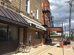
Village Office, Alexandria, Ohio.jpg
Village Office, W. Main Street
Nickname: 
Alex (pronounced "Alec")
Motto: 
Building on the Past - Preparing for the Future
OHMap-doton-Alexandria.png
Location of Alexandria, Ohio
Licking County, Ohio highlighting Alexandria.svg
Location of Alexandria in Licking County
Coordinates: 40°05′24″N82°36′43″W / 40.09000°N 82.61194°W / 40.09000; -82.61194 [1]
Country United States
State Ohio
County Licking
Area
[2]
  Total0.24 sq mi (0.63 km2)
  Land0.24 sq mi (0.63 km2)
  Water0.00 sq mi (0.00 km2)
Elevation
[1]
978 ft (298 m)
Population
 (2020)
  Total483
  Estimate 
(2023) [3]
490
  Density1,979.51/sq mi (763.03/km2)
Time zone UTC-5 (Eastern (EST))
  Summer (DST) UTC-4 (EDT)
ZIP code
43001
Area code 740
FIPS code 39-01154 [4]
GNIS feature ID2397927 [1]
Website www.alexandriaoh.gov

Alexandria is a village in Licking County, Ohio, United States. The population was 483 at the 2020 census.

Contents

History

Alexandria was laid out in 1830. [5] The village played a role in the Underground Railroad, sheltering many escaped slaves on their way to freedom.[ citation needed ]

In 2018, village voters defeated a ballot issue to dissolve the village and become a part of St. Albans Township. The vote was 92% against the dissolution. [6]

Geography

Alexandria is located in western Licking County along State Route 37 about 6 miles (10 km) southeast of Johnstown and 25 miles (40 km) northeast of Columbus. [7]

According to the United States Census Bureau, the village has a total area of 0.24 square miles (0.62 km2), all land. [8]

Demographics

Historical population
CensusPop.Note
1840 200
1850 34974.5%
1860 320−8.3%
1870 303−5.3%
1880 269−11.2%
1890 29610.0%
1900 42041.9%
1910 414−1.4%
1920 4150.2%
1930 4508.4%
1940 425−5.6%
1950 4649.2%
1960 452−2.6%
1970 58830.1%
1980 489−16.8%
1990 468−4.3%
2000 4853.6%
2010 5176.6%
2020 483−6.6%
2023 (est.)490 [3] 1.4%
U.S. Decennial Census [9]

2010 census

At the 2010 census, [10] there were 517 people, 182 households and 144 families living in the village. The population density was 2,068.0 per square mile (798.5/km2). There were 203 housing units at an average density of 812.0 per square mile (313.5/km2). The racial make-up was 98.5% White, 0.6% Native American, and 1.0% from two or more races. Hispanic or Latino of any race were 1.2% of the population.

There were 182 households, of which 50.0% had children under the age of 18 living with them, 58.8% were married couples living together, 14.8% had a female householder with no husband present, 5.5% had a male householder with no wife present, and 20.9% were non-families. 15.9% of all households were made up of individuals, and 4.4% had someone living alone who was 65 years of age or older. The average household size was 2.84 and the average family size was 3.13.

The median age was 34.9 years. 30.2% of residents were under the age of 18; 7.6% were between the ages of 18 and 24; 28.3% were from 25 to 44; 22.7% were from 45 to 64; and 11.4% were 65 years of age or older. The gender makeup of the village was 49.5% male and 50.5% female.

2000 census

At the 2000 census, [4] there were 485 people, 29 households and 22 families living in the village. The population density was 523.1 per square mile (202.0/km2). There were 30 housing units at an average density of 184.6 per square mile (71.3/km2). The racial make-up was 98.82% White and 1.18% Native American. Hispanic or Latino of any race were 1.18% of the population.

There were 29 households, of which 37.9% had children under the age of 18 living with them, 72.4% were married couples living together, and 24.1% were non-families. 20.7% of all households were made up of individuals, and 13.8% had someone living alone who was 65 years of age or older. The average household size was 2.93 and the average family size was 3.45.

34.1% of the population were under the age of 18, 4.7% from 18 to 24, 32.9% from 25 to 44, 15.3% from 45 to 64, and 12.9% were 65 years of age or older. The median age was 32 years. For every 100 females there were 107.3 males. For every 100 females age 18 and over, there were 100.0 males.

The median household income was $29,688 and the median family income was $41,250. Males had a median income of $26,250 and females $0. The per capita income was $16,235. None of the population and none of the families were below the poverty line.
Locations of interest

Located in town, Alexandria Public Library serves the residents of Alexandria. Fireman's Park, Lobdell Reserve, Parker Community Park and the Fritz Drumm Field of Dreams are all located in or very near the village. The Alexandria Museum, on Main Street, is a small house museum.

Schooling

Residents of Alexandria and the surrounding areas attend Northridge Local School District, which includes: Northridge Elementary, Northridge Middle, and Northridge High School. [11]

Related Research Articles

<span class="mw-page-title-main">Flushing, Ohio</span> Village in Ohio, United States

Flushing is a village in Belmont County, Ohio, United States. The population was 830 at the 2020 census.

<span class="mw-page-title-main">Northridge, Clark County, Ohio</span> Census-designated place in Ohio, United States

Northridge is a census-designated place (CDP) in Clark County, Ohio, United States. The population was 7,518 at the 2020 census. It is part of the Springfield, Ohio Metropolitan Statistical Area.

<span class="mw-page-title-main">Gordon, Ohio</span> Village in Ohio, United States

Gordon is a village in Darke County, Ohio, United States. The population was 245 at the 2020 census.

<span class="mw-page-title-main">Palestine, Ohio</span> Village in Ohio, United States

Palestine is a village in Darke County, Ohio, United States. The population was 180 at the 2020 census.

<span class="mw-page-title-main">Yorkshire, Ohio</span> Village in Ohio, United States

Yorkshire is a village in Darke County, Ohio, United States. The population was 95 at the 2020 census.

<span class="mw-page-title-main">Salesville, Ohio</span> Census-designated place in Ohio, United States

Salesville is a census-designated place and former village in Guernsey County, Ohio, United States. As of the 2020 census, the population was 123, down from 129 at the 2010 census. Its residents voted for dissolution in 2016.

<span class="mw-page-title-main">North Bend, Ohio</span> Village in Ohio, United States

North Bend is a village in Miami Township, Hamilton County, Ohio, United States, along the Ohio River. It is a part of the Greater Cincinnati area. The population was 835 at the 2020 census.

<span class="mw-page-title-main">New Alexandria, Ohio</span> Village in Ohio, United States

New Alexandria is a village in eastern Jefferson County, Ohio, United States. The population was 232 at the 2020 census. It is part of the Weirton–Steubenville metropolitan area.

<span class="mw-page-title-main">Brinkhaven, Ohio</span> Village in Ohio, United States

Brinkhaven, once known as Mount Holly and Gann, is a village in Knox County, Ohio, United States. The population was 114 at the 2020 census.

<span class="mw-page-title-main">Berkey, Ohio</span> Village in the United States

Berkey is a village in Lucas County, Ohio, United States. The population was 275 at the 2020 census.

<span class="mw-page-title-main">Miltonsburg, Ohio</span> Village in Ohio, United States

Miltonsburg is a village in Monroe County, Ohio, United States. The population was 42 at the 2020 census. Miltonsburg was named after Milton Pierson, son of Ohio pioneer David Pierson. David Pierson named Clarington, Ohio after his daughter Clarinda.

<span class="mw-page-title-main">Northridge, Montgomery County, Ohio</span> Unincorporated community and Census-designated place in Ohio, United States

Northridge is an unincorporated community in Harrison Township in Montgomery County, Ohio, United States. It was delineated as a census-designated place (CDP) for the 2000 census, at which time its population was 8,487. It is located directly north of the city of Dayton and is part of the Dayton Metropolitan Statistical Area.

<span class="mw-page-title-main">Adamsville, Ohio</span> Village in Ohio, United States

Adamsville is a village in Muskingum County, Ohio, United States. The population was 140 at the 2020 census. It is part of the Zanesville micropolitan area.

<span class="mw-page-title-main">Darbyville, Ohio</span> Village in Ohio, United States

Darbyville is a village in Pickaway County, Ohio, United States. The population was 186 at the 2020 census.

<span class="mw-page-title-main">Tarlton, Ohio</span> Village in Ohio, United States

Tarlton is a village in Fairfield and Pickaway counties in the U.S. state of Ohio. The population was 254 at the 2020 census.

<span class="mw-page-title-main">West Alexandria, Ohio</span> Village in Ohio, United States

West Alexandria is a village in Preble County, Ohio, United States. The population was 1,334 at the 2020 census.

<span class="mw-page-title-main">Limaville, Ohio</span> Census-designated place in Ohio, United States

Limaville is a census-designated place (CDP) and former village in Stark County, Ohio, United States. The population was 151 at the 2020 census. It is part of the Canton–Massillon Metropolitan Statistical Area.

<span class="mw-page-title-main">Orangeville, Ohio</span> Village in Ohio, United States

Orangeville is a village in eastern Trumbull County, Ohio, United States, along the state line with Pennsylvania. The population was 174 at the 2020 census. It is part of the Youngstown–Warren metropolitan area.

<span class="mw-page-title-main">Burkettsville, Ohio</span> Village in Ohio, United States

Burkettsville is a village in Darke and Mercer counties in the U.S. state of Ohio. The population was 272 at the 2020 census.

<span class="mw-page-title-main">Verona, Ohio</span> Village in Ohio, United States

Verona is a village in Montgomery and Preble counties in the U.S. state of Ohio. The population was 403 at the 2020 census. It is part of the Dayton Metropolitan Statistical Area.

References

  1. 1 2 3 U.S. Geological Survey Geographic Names Information System: Alexandria, Ohio
  2. "ArcGIS REST Services Directory". United States Census Bureau. Retrieved September 20, 2022.
  3. 1 2 "Annual Estimates of the Resident Population for Incorporated Places in Ohio: April 1, 2020 to July 1, 2023". United States Census Bureau. Retrieved May 19, 2024.
  4. 1 2 "U.S. Census website". United States Census Bureau . Retrieved January 31, 2008.
  5. Overman, William Daniel (1958). Ohio Town Names. Akron, OH: Atlantic Press. p. 2.
  6. DeVito, Maria (December 29, 2017). "Alexandria dissolution heads to the voters". Newark Advocate. Retrieved April 15, 2018.
    - DeVito, Maria (May 8, 2018). "Voters soundly reject dissolution of Alexandria". Newark Advocate. Retrieved January 4, 2019.
  7. Google (September 16, 2011). "Alexandria, Ohio" (Map). Google Maps . Google. Retrieved September 16, 2011.
  8. "U.S. Gazetteer Files: 2019: Places: Ohio". U.S. Census Bureau Geography Division. Retrieved July 9, 2020.
  9. "Census of Population and Housing". Census.gov. Retrieved June 4, 2015.
  10. "U.S. Census website". United States Census Bureau . Retrieved January 6, 2013.
  11. "School Profiles - Northridge Local Schools".