Homer, Ohio

Last updated

Homer, Ohio
Unincorporated community
Dixon Mound.jpg
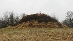
Dixon Mound, built by the Adena culture, on the community's western side
OHMap-doton-Homer.png
Location in Licking County
USA Ohio location map.svg
Red pog.svg
Homer, Ohio
Usa edcp location map.svg
Red pog.svg
Homer, Ohio
Coordinates: 40°15′10″N82°31′04″W / 40.2528414°N 82.5176626°W / 40.2528414; -82.5176626
Country United States
State Ohio
County Licking
Elevation
[1]
991 ft (302 m)
Time zone UTC−5 (Eastern (EST))
  Summer (DST) UTC−4 (EDT)
ZIP code
43027 [2]
GNIS feature ID1064854 [1]

Homer is an unincorporated community in northern Burlington Township, Licking County, Ohio, United States. [2] It lies along State Route 661 between Granville and Mount Vernon.

Contents

History

Homer was laid out in 1816. [3] The community was named after Homer, an ancient Greek poet. [4] A post office called Homer has been in operation since 1831. [5]

Notable people

Related Research Articles

<span class="mw-page-title-main">Muskingum County, Ohio</span> County in Ohio, United States

Muskingum County is a county located in the U.S. state of Ohio. As of the 2020 census, the population was 86,410. Its county seat is Zanesville. Nearly bisected by the Muskingum River, the county name is based on a Delaware American Indian word translated as "town by the river" or "elk's eye".

<span class="mw-page-title-main">Licking County, Ohio</span> County in Ohio, United States

Licking County is a county located in the central portion of the U.S. state of Ohio. At the 2020 census, the population was 178,519. Its county seat is Newark. The county was formed on January 30, 1808, from portions of Fairfield County.

<span class="mw-page-title-main">Newark, Ohio</span> City in Ohio, United States

Newark is a city in, and the county seat of, Licking County, Ohio, United States; it is located 40 miles (64 km) east of Columbus at the junction of the forks of the Licking River. The population was 49,934 at the 2020 census, making it the 18th-largest city in Ohio. It is part of the Columbus metropolitan area.

<span class="mw-page-title-main">Pataskala, Ohio</span> City in Ohio, United States

Pataskala is a city in Licking County, Ohio, United States, approximately 19 miles (31 km) east of Columbus. The population was 17,886 at the 2020 census. Pataskala was a small community until 1996, when what was then the village of Pataskala merged with Lima Township, vastly increasing its population and geographic area.

<span class="mw-page-title-main">Blacklick, Ohio</span> Unincorporated community in Ohio, United States

Blacklick is a small unincorporated community in southern Jefferson Township, Franklin County, Ohio, United States. Blacklick is also included in the Columbus Metropolitan area.

<span class="mw-page-title-main">Pike Township, Coshocton County, Ohio</span> Township in Ohio, United States

Pike Township is one of the twenty-two townships of Coshocton County, Ohio, United States. As of the 2020 census the population was 689.

<span class="mw-page-title-main">Thorn Township, Perry County, Ohio</span> Township in Ohio, United States

Thorn Township is one of the fourteen townships of Perry County, Ohio, United States. The 2020 census found 4,555 people in the township.

<span class="mw-page-title-main">Licking Township, Muskingum County, Ohio</span> Township in Ohio, United States

Licking Township is one of the twenty-five townships of Muskingum County, Ohio, United States. The 2020 census found 2,352 people in the township.

<span class="mw-page-title-main">Clay Township, Knox County, Ohio</span> Township in Ohio, United States

Clay Township is one of the twenty-two townships of Knox County, Ohio, United States. The 2020 census found 1,542 people in the township.

<span class="mw-page-title-main">Milford Township, Knox County, Ohio</span> Township in Ohio, United States

Milford Township is one of the twenty-two townships of Knox County, Ohio, United States. The 2020 census found 1,866 people in the township.

<span class="mw-page-title-main">Hanover Township, Columbiana County, Ohio</span> Township in Ohio, United States

Hanover Township is one of the eighteen townships of Columbiana County, Ohio, United States. The 2020 census reported 3,459 people living in the township.

<span class="mw-page-title-main">Burlington Township, Ohio</span> Township in Ohio, United States

Burlington Township is one of the 25 townships of Licking County, Ohio, United States. As of the 2020 census, the population was 1,209.

<span class="mw-page-title-main">Jersey Township, Licking County, Ohio</span> Township in Ohio, United States

Jersey Township is one of the 25 townships of Licking County, Ohio, United States. As of the 2020 census, the population was 2,557.

Jacksontown is a census-designated place (CDP) in central Licking Township, Licking County, Ohio, United States. It has a post office with the ZIP code 43030. It lies at the intersection of U.S. Route 40 with State Route 13.

<span class="mw-page-title-main">Brownsville, Ohio</span> Census-designated place in Ohio, United States

Brownsville is an unincorporated community and census-designated place (CDP) in northeastern Bowling Green Township, Licking County, Ohio, United States. As of the 2020 census, it had a population of 214. It lies at the intersection of U.S. Route 40 with State Route 668.

<span class="mw-page-title-main">Nashport, Ohio</span> Unincorporated community in Ohio, U.S.

Nashport is an unincorporated community and Census-designated place in western Licking Township, Muskingum County, Ohio, United States. It has a post office with the ZIP code 43830. It lies along State Route 146.

<span class="mw-page-title-main">Etna, Licking County, Ohio</span> Census-designated place in Ohio, United States

Etna is an unincorporated community and census-designated place (CDP) in Licking County, Ohio, United States. As of the 2020 census it had a population of 1,209. It lies at an elevation of 1,069 feet (326 m) at the intersection of U.S. Route 40 and State Route 310. It was listed as a census-designated place in 2010.

Amsterdam is an unincorporated community in Licking County, in the U.S. state of Ohio.

Wagram is an unincorporated community in Licking County, in the U.S. state of Ohio.

Thornport is a census-designated place in Perry County, in the U.S. state of Ohio. It is two miles north of Thornville and 22 miles north of the county seat of New Lexington. The population was 1,120 at the 2020 census.

References

  1. 1 2 U.S. Geological Survey Geographic Names Information System: Homer
  2. 1 2 Zip Code Lookup
  3. Brister, Edwin M. P. (1909). Centennial History of the City of Newark and Licking County, Ohio. S.J. Clarke Publishing Company. p. 249.
  4. Overman, William Daniel (1958). Ohio Town Names. Akron, OH: Atlantic Press. p. 62.
  5. "Licking County". Jim Forte Postal History. Retrieved December 6, 2015.