Granville South, Ohio

Last updated
Granville South, Ohio
OHMap-doton-Granville South.png
Location of Granville South, Ohio
Coordinates: 40°03′08″N82°32′30″W / 40.05222°N 82.54167°W / 40.05222; -82.54167
Country United States
State Ohio
County Licking
Township Granville
Area
[1]
  Total6.14 sq mi (15.90 km2)
  Land6.09 sq mi (15.77 km2)
  Water0.05 sq mi (0.13 km2)
Elevation
[2]
1,050 ft (320 m)
Population
 (2020)
  Total1,420
  Density233.17/sq mi (90.03/km2)
Time zone UTC-5 (Eastern (EST))
  Summer (DST) UTC-4 (EDT)
ZIP Code
43023 (Granville)
FIPS code 39-31434 [3]
GNIS feature ID2393024 [2]

Granville South is a census-designated place (CDP) in Licking County, Ohio, United States. The population was 1,420 at the 2020 census.

Contents

Geography

Granville South is located in central Licking County in the southern and southwestern part of Granville Township. It is bordered to the north by the village of Granville.

Ohio State Route 16 passes through the community, leading east 8 miles (13 km) to Newark, the county seat, and southwest 25 miles (40 km) to Columbus. State Route 37 forms the northern edge of most of the community; the highway leads northwest 21 miles (34 km) to Sunbury. State Route 37 and 161 form a freeway which leads west 20 miles (32 km) to Interstate 270 in the northeastern suburbs of Columbus.

According to the United States Census Bureau, the Granville South CDP has a total area of 6.1 square miles (15.9 km2), of which 0.04 square miles (0.1 km2), or 0.79%, are water. [4] The CDP drains northeast to Raccoon Creek, an east-flowing tributary of the Licking River and part of the Muskingum River watershed flowing south to the Ohio River.

Demographics

Historical population
CensusPop.Note
2020 1,420
U.S. Decennial Census [5]

At the 2000 census there were 1,194 people, 424 households, and 362 families living in the CDP. The population density was 195.4 inhabitants per square mile (75.4/km2). There were 433 housing units at an average density of 70.9 per square mile (27.4/km2). The racial makeup of the CDP was 97.40% White, 0.08% Native American, 1.17% Asian, 0.34% from other races, and 1.01% from two or more races. Hispanic or Latino of any race were 0.67%. [3]

Of the 424 households 41.5% had children under the age of 18 living with them, 79.5% were married couples living together, 4.7% had a female householder with no husband present, and 14.4% were non-families. 13.2% of households were one person and 6.8% were one person aged 65 or older. The average household size was 2.82 and the average family size was 3.09.

The age distribution was 28.6% under the age of 18, 4.5% from 18 to 24, 22.5% from 25 to 44, 32.6% from 45 to 64, and 11.8% 65 or older. The median age was 42 years. For every 100 females there were 91.7 males. For every 100 females age 18 and over, there were 90.0 males.

The median household income was $65,694 and the median family income was $77,301. Males had a median income of $57,202 versus $25,217 for females. The per capita income for the CDP was $27,043. None of the families and 1.3% of the population were living below the poverty line, including no under eighteens and 5.9% of those over 64.

Related Research Articles

<span class="mw-page-title-main">Licking County, Ohio</span> County in Ohio, United States

Licking County is a county located in the central portion of the U.S. state of Ohio. At the 2020 census, the population was 178,519. Its county seat is Newark. The county was formed on January 30, 1808, from portions of Fairfield County.

Grandwood Park is a census-designated place (CDP) in Warren Township, Lake County, Illinois, United States. Per the 2020 census, the population was 5,297.

<span class="mw-page-title-main">Claryville, Kentucky</span> Census-designated place in Kentucky, United States

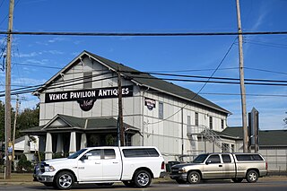
Claryville is an unincorporated community and census-designated place (CDP) in Campbell County, Kentucky, United States. The population was 2,992 at the 2020 census.

<span class="mw-page-title-main">Ross, Ohio</span> Census-designated place in Ohio, United States

Ross is a census-designated place (CDP) in Ross Township, Butler County, Ohio, United States. The population was 3,478 at the 2020 census. Ross sits along U.S. Route 27 between Cincinnati, Ohio and Oxford, Ohio. Ross is part of the Cincinnati metropolitan area.

<span class="mw-page-title-main">Northridge, Clark County, Ohio</span> Census-designated place in Ohio, United States

Northridge is a census-designated place (CDP) in Clark County, Ohio, United States. The population was 7,518 at the 2020 census. It is part of the Springfield, Ohio Metropolitan Statistical Area.

<span class="mw-page-title-main">Park Layne, Ohio</span> Census-designated place in Ohio, United States

Park Layne is a census-designated place (CDP) in Bethel Township, Clark County, Ohio, United States. The population of the CDP was 4,248 at the 2020 census. It is part of the Springfield, Ohio Metropolitan Statistical Area. Park Layne became a CDP in the 1980 United States Census.

<span class="mw-page-title-main">Day Heights, Ohio</span> Census-designated place in Ohio, United States

Day Heights is a census-designated place (CDP) in Clermont County, Ohio, United States. The population was 2,625 at the 2020 census.

<span class="mw-page-title-main">Mount Repose, Ohio</span> Census-designated place in Ohio, United States

Mount Repose is a census-designated place (CDP) in Miami Township, Clermont County, Ohio, United States. The population was 4,648 at the 2020 census.

<span class="mw-page-title-main">Calcutta, Ohio</span> Census-designated place in Ohio, United States

Calcutta is an unincorporated community and census-designated place in southeastern Columbiana County, Ohio, United States. The population was 3,941 at the 2020 census. Historically a rural town, Calcutta grew as businesses from neighboring East Liverpool moved into larger shopping centers clustered around Ohio State Route 170.

<span class="mw-page-title-main">Fairfield Beach, Ohio</span> Census-designated place in Ohio, United States

Fairfield Beach is an unincorporated community and census-designated place (CDP) in Fairfield County, Ohio, United States. The population was 1,267 at the 2020 census.

<span class="mw-page-title-main">Huber Ridge, Ohio</span> Census-designated place in Ohio, United States

Huber Ridge is a census-designated place (CDP) in Blendon Township, Franklin County, Ohio, United States. The population was 4,940 at the 2020 census.

<span class="mw-page-title-main">Lake Darby, Ohio</span> Census-designated place in Ohio, United States

Lake Darby is an unincorporated community and census-designated place in Franklin County, Ohio, United States, located mostly in Prairie Township and partly in Brown Township. It is more commonly known among locals as Darby Estates, which is also the name of the older housing development there, with the newer development called "West Point". As of the 2020 census, the CDP had a population of 4,731.

<span class="mw-page-title-main">Beechwood Trails, Ohio</span> Census-designated place in Ohio, United States

Beechwood Trails is a census-designated place (CDP) in Harrison Township, Licking County, Ohio, United States. The population was 3,276 at the 2020 census.

<span class="mw-page-title-main">Harbor Hills, Ohio</span> Census-designated place in Ohio, United States

Harbor Hills is a census-designated place (CDP) in southern Licking County, Ohio, United States. The population was 1,565 at the 2020 census.

<span class="mw-page-title-main">Eaton Estates, Ohio</span> Census-designated place in Ohio, United States

Eaton Estates is an unincorporated community and census-designated place (CDP) in Lorain County, Ohio, United States. The population was 1,155 at the 2020 census.

<span class="mw-page-title-main">Lightstreet, Pennsylvania</span> Census-designated place in Pennsylvania, United States

Lightstreet is a census-designated place (CDP) in Columbia County, Pennsylvania, United States. It is part of Northeastern Pennsylvania. The population was 1,093 at the 2010 census. It is part of the Bloomsburg-Berwick micropolitan area. The CDP is named after a street in Baltimore.

<span class="mw-page-title-main">Oakwood, Pennsylvania</span> Census-designated place in Pennsylvania, United States

Oakwood is an unincorporated area and census-designated place (CDP) in Lawrence County, Pennsylvania, United States. The population was 2,270 at the 2010 census.

<span class="mw-page-title-main">North Spearfish, South Dakota</span> Census-designated place in South Dakota, United States

North Spearfish is a census-designated place (CDP) in Lawrence County, South Dakota, United States. The population was 2,366 at the 2020 census.

Bainbridge is a census-designated place (CDP) in Bainbridge Township, Geauga County, Ohio, United States. As of the 2020 census, the CDP had a population of 9,242.

Bethlehem is a census-designated place (CDP) and the main village in the town of Bethlehem in Grafton County, New Hampshire, United States. The population of the CDP was 826 at the 2020 census, out of 2,484 in the entire town.

References

  1. "ArcGIS REST Services Directory". United States Census Bureau. Retrieved September 20, 2022.
  2. 1 2 U.S. Geological Survey Geographic Names Information System: Granville South, Ohio
  3. 1 2 "U.S. Census website". United States Census Bureau . Retrieved 2008-01-31.
  4. "U.S. Gazetteer Files: 2019: Places: Ohio". U.S. Census Bureau Geography Division. Retrieved July 17, 2020.
  5. "Census of Population and Housing". Census.gov. Retrieved June 4, 2016.