Clearfield Colony, South Dakota | |
|---|---|
 Clearfield Colony  Clearfield Colony | |
| Coordinates: 43°08′38″N98°08′31″W / 43.14389°N 98.14194°W | |
| Country | United States |
| State | South Dakota |
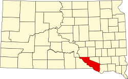
| County | Charles Mix |
| Area | |
• Total | 0.30 sq mi (0.78 km2) |
| • Land | 0.30 sq mi (0.78 km2) |
| • Water | 0 sq mi (0.00 km2) |
| Elevation | 1,729 ft (527 m) |
| Population | |
• Total | 99 |
| • Density | 327.1/sq mi (126.29/km2) |
| Time zone | UTC-6 (Central (CST)) |
| • Summer (DST) | UTC-5 (CDT) |
| ZIP Code | 57330 (Delmont) |
| Area code | 605 |
| FIPS code | 46-12508 |
| GNIS feature ID | 2813005 [2] |
Clearfield Colony is a Hutterite colony [4] and census-designated place (CDP) within the Yankton Indian Reservation in Charles Mix County, South Dakota, United States. It was first listed as a CDP prior to the 2020 census. The population of the CDP was 99 at the 2020 census. [5]
Contents
It is in the eastern part of the county, 10 miles (16 km) south of Delmont and 12 miles (19 km) northeast of Wagner.