Clearwater or Clear Water may refer to:

The Chipewyan are a Dene Indigenous Canadian people of the Athabaskan language family, whose ancestors are identified with the Taltheilei Shale archaeological tradition. They are part of the Northern Athabascan group of peoples, and hail from what is now Western Canada.

Clearwater is a river of southern Alberta, Canada. Situated entirely in the Canadian Rockies and the Rocky Mountain foothills of Alberta, it is a glacier fed upper reach tributary of the North Saskatchewan River. The upper reach of the Clearwater has become popular for equestrian travelers due to the natural setting along the river.
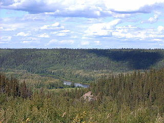
The Clearwater River is located in the Canadian provinces of Saskatchewan and Alberta. It rises in the northern forest region of north-western Saskatchewan and joins the Athabasca River in north-eastern Alberta. It was part of an important trade route during the fur trade era and has been designated as a Canadian Heritage River.

Northern Manitoba is a geographic and cultural region of the Canadian province of Manitoba. Originally encompassing a small square around the Red River Colony, the province was extended north to the 60th parallel in 1912. The region's specific boundaries vary, as "northern" communities are considered to share certain social and geographic characteristics, regardless of latitude.
Clearwater is an unincorporated community recognized as a local urban district in south central Manitoba, Canada. It is located in the Municipality of Louise. It plays host to the Harvest Moon Festival, a music and organic farming event held each September. Clearwater is also the site of an annual July 1 Canada Day baseball tournament.
Clearwater Lake or Lake Clearwater may refer to:

The Lac Wiyâshâkimî, also called the Clearwater Lakes in English and Allait Qasigialingat by the Inuit, are a pair of annular lakes and impact craters on the Canadian Shield in Quebec, Canada, near Hudson Bay.
Wekusko Falls Provincial Park is a provincial park straddling the Grass River and Wekusko Lake, located in central Manitoba on Manitoba Provincial Road 392 near Snow Lake, Manitoba.

The Boreal Plains Ecozone, as defined by the Commission for Environmental Cooperation (CEC), is a terrestrial ecozone in the western Canadian provinces of Manitoba, Saskatchewan and Alberta. It also has minor extensions into northeastern British Columbia and south-central Northwest Territories. The region extends over 779,471 km2, of which 58,981 km2 is conserved.
Lake Metigoshe State Park is a public recreation area occupying some 1,500 acres (610 ha) on the shores of Lake Metigoshe in the Turtle Mountains, 14 miles northeast of Bottineau, North Dakota, on the Canada–US border. The state park lies adjacent to the southwest corner of the much larger Turtle Mountain Provincial Park in Manitoba. A small portion of the lake extends northward into the Rural Municipality of Winchester but is not part of either park.
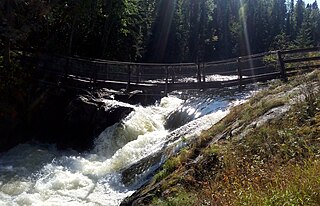
Grass River Provincial Park is a 2,279 km2 provincial park in Northwestern Manitoba, Canada. Designated in 1963, the park is approximately 75 km north of The Pas and is centered on the Grass River. The southern part of the park includes portions of the dolomitic Manitoba Lowlands portion of the Interior Plains, while the northern portion includes part of the granitic Canadian Shield. It it crossed east-west by Manitoba Highway 39, with PTH 10 crossing the western edge of the park. The entire park shows evidence of glaciation. The park is considered to be a Class III protected area under the IUCN protected area management categories.

Wells Gray Provincial Park is a large wilderness park located in east-central British Columbia, Canada. The park protects most of the southern, and highest, regions of the Cariboo Mountains and covers 5,415 square kilometres. It is British Columbia's fifth largest provincial park, after Tweedsmuir, Tatshenshini, Spatsizi and Northern Rocky Mountains.

Lundar Beach Provincial Park is a provincial park on the east shore of Lake Manitoba in Manitoba, Canada. It is located in the Rural Municipality of Coldwell, 18 kilometres west of Lundar, Manitoba.
The Broad River is a river in the Hudson Bay drainage basin in Census division 23 in Northern Manitoba, Canada. Its flows from an unnamed lake to Hudson Bay.
Clearwater Lake Provincial Park was designated a provincial park by the Government of Manitoba in 1963. The park is 593 square kilometres (229 sq mi) in size. The park is considered to be a Class II protected area under the IUCN protected area management categories.

Hakatere Conservation Park is a protected area between the Rakaia River and the Rangitata River in the Ashburton District of New Zealand. The park was established in 2007. It covers 60,000 hectares of rugged mountains and mountain basins, tussocklands and beech forest. It includes the Ashburton Lakes, such as Lake Heron and Lake Clearwater, popular tramping area Mount Somers / Te Kiekie, and Mount Hutt skifield. The closest town is Mount Somers.

Purple beaches are a phenomenon caused by the presence of a large amounts of almandine-pyrope garnet. or other purple minerals like manganese or rose quartz that have accumulated in the local sediment. These purple beaches are primarily found in the western Canadian Shield region of Canada or the Northern Continental United States; often in proximity to a major river systems with coarse sediment, a glacial sediment source, or input from glacial or para-glacial sediment. Purple sand can also be caused by purple paint mixing with the quartz in sand.


