Erie County is a county along the shore of Lake Erie in western New York State. As of the 2020 census, the population was 954,236. The county seat is Buffalo, which makes up about 28% of the county's population. Both the county and Lake Erie were named for the regional Iroquoian language-speaking Erie tribe of Native Americans, who lived in the area before 1654. They were later pushed out by the more powerful Iroquoian nations tribes.

North Boston is a hamlet and census-designated place (CDP) in the town of Boston in Erie County, New York, United States. As of the 2010 census, the CDP population was 2,521. It is part of the Buffalo–Niagara Falls Metropolitan Statistical Area.

Sloan is a village in Erie County, New York, United States. The population was 3,661 at the 2010 census. It is part of the Buffalo–Niagara Falls Metropolitan Statistical Area and is in the town of Cheektowaga.
Worth is a town in Jefferson County, New York, United States. The population was 231 at the 2010 census. The town is named after William Worth, a commander of troops during the Battle of Sackett's Harbor.

Richfield is a town located in Otsego County, New York, United States. As of the 2010 census, the town had a population of 2,388. The Town of Richfield is located at the northern border of the county.
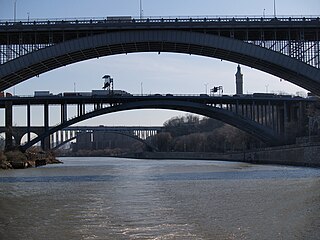
The Harlem River is an 8-mile (13 km) tidal strait in New York, United States, flowing between the Hudson River and the East River and separating the island of Manhattan from the Bronx on the New York mainland.

Biquinhas is a municipality in the north of the Brazilian state of Minas Gerais. As of 2020, the population was 2,498 in a total area of 457 square kilometers. It became a municipality in 1962.
125th Street, co-named Martin Luther King Jr. Boulevard, is a two-way street that runs east–west in the New York City borough of Manhattan, from First Avenue on the east to Marginal Street, a service road for the Henry Hudson Parkway along the Hudson River in the west. It is often considered to be the "Main Street" of Harlem.
New York State Route 324 (NY 324) is an east–west state highway located in the western portion of New York in the United States. Officially, NY 324 begins at NY 384 in Niagara Falls and overlaps Interstate 190 south to Grand Island, where it separates from I-190 and continues southward as Grand Island Boulevard. As signed, however, NY 324 begins at the southern end of the official overlap and is contained entirely within Erie County. At the southern edge of Grand Island, NY 324 joins I-190 to cross over to the mainland, where it runs due east across three towns before reaching its eastern end at a junction with NY 5 in the town of Clarence.

The Lebanon Countryside Trail is a rail trail in Ohio.

Dyckman Street, occasionally called West 200th Street, is a street in the Inwood neighborhood of Manhattan, New York City. It is commonly considered to be a crosstown street because it runs from the Hudson River to the Harlem River and intersects Broadway. However, in its true geographical orientation, Dyckman Street runs roughly from north-northwest to south-southeast, and the majority of the street that lies southeast of Broadway runs closer to a north-south direction than east-west.

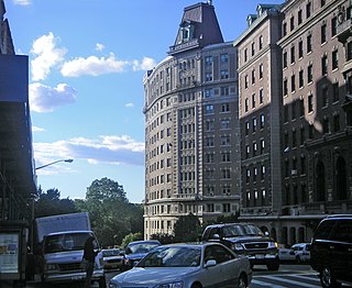
155th Street is a crosstown street separating the Harlem and Washington Heights neighborhoods, in the New York City borough of Manhattan. It is the northernmost of the 155 crosstown streets mapped out in the Commissioner's Plan of 1811 that established the numbered street grid in Manhattan. The street consists of a "high portion" which is a major artery through the area, as well as a lesser-used "low portion".

Cleveland is an unincorporated community in suburban northwestern Johnston County, North Carolina, United States. It lies at an elevation of 243 feet (74 m). The settlement is also known as Cleveland Crossings, Cleveland Community, Cleveland School or 40/42, so named for the intersection of I-40 and NC 42 at the northeastern edge of the community, which serves as the primary commercial hub of the area. NC 50 skirts the western edge of the community. The community's population is concentrated along Cleveland Road in Johnston County. While officially unincorporated, postal addresses for the community generally lie in Garner, Clayton and Benson. The community is named for the Cleveland School, a former K-12 school lying on Cleveland Road, the grounds of which currently house a community center, senior adult housing, a gymnasium and numerous athletic fields managed by the Greater Cleveland Athletic Association (GCAA), and a branch of the Johnston Community College. Nearby unincorporated communities include McGee's Crossroads to the south along NC 50 and Willow Spring to the west along NC 42.
Bowmansville is a hamlet located in the town of Lancaster in Erie County, New York, United States. It is named after Benjamin Bowman, the owner of sawmills on Ellicott Creek in the center of the hamlet.

133rd Street is a street in Manhattan and the Bronx, New York City. In Harlem, Manhattan, it begins at Riverside Drive on its western side and crosses Broadway, Amsterdam Avenue, and ends at Convent Avenue, before resuming on the eastern side, crossing Seventh Avenue, and ending at Lenox Avenue. In Port Morris in the Bronx, it runs from Bruckner Boulevard/St. Ann's Place to Locust Avenue. The block between Seventh Avenue and Lenox Avenues was once a thriving night spot, known as "Swing Street", with numerous cabarets, jazz clubs, and speakeasies. The street is described in modern times as "a quiet stretch of brownstones and tenement-style apartment houses, the kind of block that typifies this section of central Harlem".
The 1912 U.S. Open was the 18th U.S. Open, held August 1–2 at the Country Club of Buffalo in Amherst, New York, a suburb east of Buffalo. Twenty-year-old John McDermott successfully defended his U.S. Open title, two strokes ahead of runner-up Tom McNamara.

Kensington is a neighborhood of Buffalo, New York, located in the northeastern part of the city. It is sometimes referred to as Kensington-Bailey, due to the intersection at Kensington and Bailey Avenues, the two major commercial streets in the neighborhood.