Related Research Articles

Erie County is a county along the shore of Lake Erie in western New York State. As of the 2020 census, the population was 954,236. The county seat is Buffalo, which makes up about 28% of the county's population. Both the county and Lake Erie were named for the regional Iroquoian language-speaking Erie tribe of Native Americans, who lived in the area before 1654. They were later pushed out by the more powerful Iroquoian nations tribes.
Depew is a village in Erie County, New York. The population was 15,303 at the time of the 2010 census. It is part of the Buffalo–Niagara Falls metropolitan area. The village is named for Chauncey Depew, a politician and one of the original investors who bought the land for the village, which was incorporated in 1894.

Sloan is a village in Erie County, New York, United States. The population was 3,661 at the 2010 census. It is part of the Buffalo–Niagara Falls Metropolitan Statistical Area and is in the town of Cheektowaga.

Cheektowaga is a suburban community and census-designated place (CDP) in Erie County, New York, United States. The population was 75,178 at the 2010 census, making it the most populous census-designated place in New York. It is within the town of Cheektowaga. The CDP includes Buffalo Niagara International Airport.

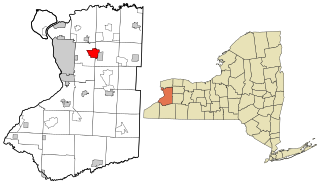
Cheektowaga is a town in Erie County, New York, United States. As of the 2020 census, the town has grown to a population of 89,877. The town is in the north-central part of the county, and is an inner ring suburb of Buffalo. The town is the second-largest suburb of Buffalo, after the Town of Amherst.

West Seneca is a town in Erie County, New York, United States. The population was 45,500 at the 2020 census. West Seneca is a centrally located interior town of the county, and a suburb of Buffalo. West Seneca, Orchard Park and Hamburg form the inner "Southtowns", a cluster of middle-class suburban towns.
Nogo is a small unincorporated community in Smyrna Township, Pope County, Arkansas, United States. It is part of the Russellville Micropolitan Statistical Area.
Maryvale High School is a high school in Cheektowaga, New York, United States. It is a member of the Maryvale Union Free School District. As of the 2017-18 school year, the school has approximately 665 students.

The Buffalo–Niagara Falls Metropolitan Statistical Area is a metropolitan area, designated by the United States Census Bureau, encompassing two counties — Erie and Niagara in Western New York. It has a population of almost 1.2 million people. It is the second-largest metropolitan area in the state of New York, centering on the urbanized area of Buffalo. As of April 1, 2020, the metropolitan statistical area (MSA) had a population of 1,166,902. The larger Buffalo Niagara Region is an economic zone consisting of eight counties in Western New York.
The East Side is a large district of Buffalo, New York, and the city's physically largest neighborhood. It is bordered by Main Street to the north and west, I-190 and the Kaisertown neighborhood to the south, and the town of Cheektowaga to the east. Large, ornate 19th-century churches, most of them Roman Catholic, and modest 1+1⁄2-story wood-frame cottages, often with progressively smaller rear additions that give a telescoping effect, characterize the district. The East Side was once the second largest Polish-American community in the United States. Jefferson Avenue, and the intersection of Broadway and Fillmore, serve as its most heavily used commercial districts.

Hodges Village Dam, a United States Army Corps of Engineers flood control project on the French River (Massachusetts) in Oxford, Massachusetts was built in 1959 as a response to the 1936 floods which took lives and caused tremendous property damage in the Thames River basin of Connecticut. The western side of the French River is open to hunting, fishing, hiking, and boating. There are more than 18.2 miles of hiking trails on the property, as well as motorized bike trails on the west side of the river. ATV's and quads are restricted from the area. However, motorized bikes are allowed only on the west side of the river. There is a frisbee golf course that runs alongside the dam.
Bowmansville is a hamlet located in the town of Lancaster in Erie County, New York, United States. It is named after Benjamin Bowman, the owner of sawmills on Ellicott Creek in the center of the hamlet.

Bellevue is a hamlet in the town of Cheektowaga in Erie County, New York, United States.
Cleveland Hill is a hamlet in the town of Cheektowaga in Erie County, New York, United States. It is the location of the Cleveland Hill School District. Cleveland Hill is often called Cleve Hill. The center of Cleveland Hill is located at Harlem Road and Cleveland Drive. Cleveland Hill is unique in that the Onondaga Escarpment runs through it with the elevation at Harlem Road and Cleveland Drive being 215 meters (705 ft). The elevation decreases as one heads north or south on Harlem Road. Only if one heads east towards the Buffalo Niagara International Airport does the elevation stay the same or increase slightly.
Pine Hill is a hamlet in the town of Cheektowaga in Erie County, New York, United States.
The Lovejoy District is a neighborhood in Buffalo, New York. Lovejoy is the easternmost portion of the city, running along the city's border with Cheektowaga. The councilman of the area in 2017 is Richard Fontana.
Woodbine is an unincorporated community in York County, Pennsylvania, United States. Until 1978, this community was served by the Maryland and Pennsylvania Railroad at milepost 50.6.

Kents Store is an unincorporated community in Fluvanna County, in the U.S. state of Virginia.
South Cheektowaga is a neighborhood on the West Seneca border near French Road, in the town of Cheektowaga, in Erie County, New York, United States.
Schiller Park is a neighborhood of easternmost Buffalo, New York, at the Cheektowaga border.
References
- ↑ "Doyle". Geographic Names Information System . United States Geological Survey, United States Department of the Interior . Retrieved August 17, 2016.
42°52′46″N78°47′05″W / 42.87944°N 78.78472°W

| | This article about a location in Erie County, New York is a stub. You can help Wikipedia by expanding it. |