Clifford, Illinois | |
|---|---|
 Clifford, Illinois  Clifford, Illinois | |
| Coordinates: 37°49′25″N89°04′38″W / 37.82361°N 89.07722°W | |
| Country | United States |
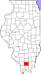
| State | Illinois |
| County | Williamson |
| Elevation | 387 ft (118 m) |
| Time zone | UTC-6 (Central (CST)) |
| • Summer (DST) | UTC-5 (CDT) |
| ZIP Code | 62918 |
| Area code | 618 |
| GNIS feature ID | 422564 [1] |
Clifford is a former unincorporated community in northwestern Williamson County, Illinois. It is a former early 20th century mining settlement that has almost disappeared since the closing of local mines.
A post office was established on 26 January 1905, and it remained in operation until after 1931.
The population in 1958 was listed as 300. [2]