Cloudripper

Last updated
Cloudripper
Cloudripper.jpg
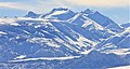
West aspect, (Chocolate Peak to the right)
Highest point
Elevation 13,525 ft (4,122 m)  NAVD 88 [1]
Prominence 845 ft (258 m) [1]
Parent peak Mount Agassiz (13,899 ft) [2]
Isolation 2.12 mi (3.41 km) [2]
Listing Sierra Peaks Section
Coordinates 37°08′34″N118°31′50″W / 37.1427527°N 118.5304693°W / 37.1427527; -118.5304693 Coordinates: 37°08′34″N118°31′50″W / 37.1427527°N 118.5304693°W / 37.1427527; -118.5304693 [3]
Geography
Relief map of California.png
Red triangle with thick white border.svg
Cloudripper
Usa edcp relief location map.png
Red triangle with thick white border.svg
Cloudripper
Location Inyo County, California, U.S.
Parent range Sierra Nevada
Palisades
Inconsolable Range [1]
Topo map USGS Mount Thompson
Climbing
First ascent 1926 or 1927 Norman Clyde
Easiest route East Ridge

Cloudripper is a 13,525-foot-elevation (4,122 meter) mountain summit located two miles east of the crest of the Sierra Nevada mountain range in Inyo County of northern California, United States. [3] It is situated in the Palisades area of the John Muir Wilderness, on land managed by Inyo National Forest. It is approximately 14 miles (23 km) west of the community of Big Pine, 1.1 miles (1.8 km) north-northeast of Picture Puzzle, and 2.1 miles (3.4 km) south of parent Mount Agassiz. Cloudripper ranks as the 58th highest summit in California, [2] and the highest point of the Inconsolable Range. [1]

Contents


Climbing

Established climbing routes on Cloudripper: [4]

The first ascent of the summit was made June 15, 1927, by Norman Clyde, who is credited with 130 first ascents, most of which were in the Sierra Nevada. [4] [6] Other sources place the date as June 15, 1926. [7] [8]

Climate

According to the Köppen climate classification system, Cloudripper is located in an alpine climate zone. [9] Most weather fronts originate in the Pacific Ocean, and travel east toward the Sierra Nevada mountains. As fronts approach, they are forced upward by the peaks, causing them to drop their moisture in the form of rain or snowfall onto the range (orographic lift). Precipitation runoff from this mountain drains east into North Fork Big Pine Creek, and northwest into headwaters of Bishop Creek.

Cloudripper in winter Cloudripper winter.jpg
Cloudripper in winter
Cloudripper's summit Cloudripper east ridge.jpg
Cloudripper's summit

See also

Related Research Articles

Mount Dade

Mount Dade is a 13,606 feet (4,147 m) mountain located on the crest of the Sierra Nevada mountain range in northern California, United States. It is situated in the John Muir Wilderness on the boundary between Sierra National Forest and Inyo National Forest, and along the common border of Fresno County with Inyo County. It is one mile west of Dade Lake, and approximately 22 miles (35 km) west of the community of Bishop. Nearby neighbors include Mount Abbot, 0.4 mile to the northwest, and Bear Creek Spire 1.2 mile to the southeast. The USGS probably named this peak during a 1907–09 survey, and the first ascent was made August 19, 1911, by Liston and McKeen, of Fresno.

Mount Thompson (California)

Mount Thompson is a 13,494-foot-elevation mountain summit located on the crest of the Sierra Nevada mountain range in California, United States. It is situated on the shared boundary of Kings Canyon National Park with John Muir Wilderness, and along the common border of Fresno County with Inyo County. It is also 18 miles (29 km) west of the community of Big Pine, one mile northwest of Mount Gilbert, and three miles east of Mount Fiske, which is the nearest higher neighbor. Mount Thompson ranks as the 62nd-highest summit in California. This mountain's name commemorates Almon Harris Thompson (1839–1906). The first ascent of the peak was made by Clarence H. Rhudy and H. F. Katzenbach in the summer of 1909.

Langille Peak Mountain in California, United States of America

Langille Peak is a 12,018-foot-elevation mountain summit located near the crest of the Sierra Nevada mountain range, in Fresno County of northern California, United States. It is situated in northern Kings Canyon National Park, 19 miles (31 km) west-southwest of the community of Big Pine, 3 miles (4.8 km) south of Mount Thompson, 2.8 miles (4.5 km) southwest of Mount Goode, and 2.1 miles (3.4 km) east of Black Giant. Topographic relief is significant as the east aspect rises 3,100 feet (945 meters) above LeConte Canyon in less than one mile. The approach to this remote peak is made via the John Muir Trail.

Mount Gayley

Mount Gayley is a 13,510-foot-elevation mountain summit located one mile east of the crest of the Sierra Nevada mountain range in Inyo County, California, United States. It is situated in the Palisades area of the John Muir Wilderness, on land managed by Inyo National Forest. It is approximately 13 miles (21 km) west-southwest of the community of Big Pine, 0.67 miles (1.08 km) southwest of Temple Crag, and 0.5 miles (0.80 km) north-northeast of parent Mount Sill. Mount Gayley ranks as the 59th highest summit in California.

Mount Haeckel

Mount Haeckel is a 13,424-foot (4,092 m) mountain summit located on the crest of the Sierra Nevada mountain range in northern California, United States. It is situated on the shared boundary of Kings Canyon National Park with John Muir Wilderness, and along the common border of Fresno County with Inyo County. It is 21.5 miles (34.6 km) west of the community of Big Pine, 1.27 miles (2.04 km) south-southeast of Mount Darwin, and one mile north-northeast of Mount Fiske, which is the nearest higher neighbor. Mount Haeckel ranks as the 71st highest summit in California.

Picture Puzzle

Picture Puzzle, also known as Picture Puzzle Peak, is a 13,297-foot-elevation mountain summit located one mile east of the crest of the Sierra Nevada mountain range in Inyo County of northern California, United States. It is situated in the Palisades area of the John Muir Wilderness, on land managed by Inyo National Forest. It is approximately 14.5 miles (23.3 km) west of the community of Big Pine, one mile north of Bishop Pass, 1.2 miles (1.9 km) north-northwest of Mount Agassiz, and 1.1 miles (1.8 km) south-southwest of parent Cloudripper. Picture Puzzle ranks as the 90th highest summit in California, and the third highest peak of the Inconsolable Range.

Hurd Peak

Hurd Peak is a 12,237-foot-elevation mountain summit located one mile east of the crest of the Sierra Nevada mountain range in Inyo County of northern California, United States. Surrounded by lakes, it is situated in the John Muir Wilderness, on land managed by Inyo National Forest. It is approximately 16 miles (26 km) west of the community of Big Pine, 2 miles (3.2 km) west of Picture Puzzle, and 1.23 miles (1.98 km) north of parent Mount Goode. Topographic relief is significant as the north aspect rises nearly 2,500 feet (760 meters) above South Lake in approximately one mile.

Red and White Mountain

Red and White Mountain is a remote 12,816-foot-elevation mountain summit located on the crest of the Sierra Nevada mountain range in northern California, United States. It is situated in the John Muir Wilderness on the shared boundary of Sierra National Forest with Inyo National Forest, and along the common border of Fresno County with Mono County. It is eight miles northeast of Lake Thomas A Edison, and approximately 13 miles (21 km) southeast of the community of Mammoth Lakes. The nearest higher neighbor is Red Slate Mountain, 2 miles (3.2 km) to the north-northwest.

North Guard

North Guard is a remote 13,327-foot-elevation mountain summit located near the northern end of the Great Western Divide of the Sierra Nevada mountain range, in Tulare County of northern California. It is situated in Kings Canyon National Park, 0.9 miles (1.4 km) southeast of Mount Farquhar, and 0.6 miles (0.97 km) north-northwest of Mount Brewer, which is the nearest higher neighbor. Topographic relief is significant as the east aspect rises 3,858 feet (1,176 meters) above East Lake in three miles. North Guard ranks as the 87th highest summit in California, and the second highest point of the northern Great Western Divide. It's not as high as Mount Brewer, but offers better climbing and is considered one of the classic climbing routes in the Sierra Nevada.

Independence Peak (California)

Independence Peak is an 11,742-foot-elevation mountain summit located one mile east of the crest of the Sierra Nevada mountain range, in Inyo County of northern California. It is situated immediately south of Onion Valley on the eastern boundary of John Muir Wilderness, on land managed by Inyo National Forest. It is also 8 miles (13 km) west-southwest of the community of Independence, and 1.9 miles (3.1 km) northeast of parent University Peak. Topographic relief is significant as the north aspect rises 3,600 feet (1,100 meters) above Onion Valley in one mile. Independence Peak can be climbed via the north slope from Onion Valley. The first ascent of the summit was made in 1926 by Norman Clyde, who is credited with 130 first ascents, most of which were in the Sierra Nevada. He climbed this peak three times in 1926, and twice in 1927. He was principal of the high school in Independence from 1924 to 1928, which provided him access to this nearest peak to his home.

Colosseum Mountain

Colosseum Mountain is a 12,473-foot-elevation double summit mountain located on the crest of the Sierra Nevada mountain range in northern California. It is situated on the common border of Fresno County with Inyo County, as well as the shared boundary of John Muir Wilderness and Kings Canyon National Park. It is 12 miles (19 km) northwest of the community of Independence, 1.2 miles (1.9 km) east of Mount Cedric Wright, and 1.6 miles (2.6 km) south-southeast of Mount Perkins, the nearest higher neighbor. The lower east summit is 12,451-feet in elevation and marked as Colosseum Mountain on maps, but the 12,473-foot west summit is higher. Approximately 1,000 feet distance separate the two summits. The John Muir Trail passes to the west of this peak, providing an approach to the mountain. The first ascent of the summit was made August 5, 1922, by Chester Versteeg, a prominent Sierra Club member, via the southwest face.

The Hermit (California mountain)

The Hermit is a 12,328-foot-elevation mountain summit located west of the crest of the Sierra Nevada mountain range, in Fresno County of northern California, United States. It is situated in northern Kings Canyon National Park, 2.5 miles (4.0 km) east of Emerald Peak, and 2.5 miles (4.0 km) west of Mount Darwin. Topographic relief is significant as the north aspect rises 2,500 feet (762 meters) above Evolution Valley in less than one mile. The John Muir Trail passes to the east and north of this landmark, providing an approach. This geographical feature was named by Sierra Club explorer Theodore Solomons in 1895 as he wrote: "The traveler will be greatly attracted by a very sharp peak or butte that rises on the south wall. From its isolated position as viewed from the valley we called it the Hermit."

Kearsarge Peak

Kearsarge Peak is a 12,615-foot-elevation (3,845 meter) mountain summit located less than two miles east of the crest of the Sierra Nevada mountain range, in Inyo County of northern California. It is situated immediately northwest of Onion Valley in the John Muir Wilderness, on land managed by Inyo National Forest. It is also 8.5 miles (13.7 km) west of the community of Independence, and 2.1 miles (3.4 km) north-northwest of Independence Peak. Topographic relief is significant as the east aspect rises 5,250 feet (1,600 meters) above Onion Valley in two miles.

Mount Corcoran

Mount Corcoran is a 13,714-foot (4,180 m) mountain summit located on the crest of the Sierra Nevada mountain range in California. It is situated on the boundary between Tulare County and Inyo County, as well as the boundary between Sequoia National Park and John Muir Wilderness. It is 12 miles (19 km) west-southwest of the community of Lone Pine, 3.6 miles (5.8 km) southeast of Mount Whitney, 1.2 mile (1.9 km) northwest of Mount Langley, and 0.23 mile (0.37 km) immediately south of Mount Le Conte, the nearest higher neighbor. Topographic relief is significant as it rises approximately 1,800 feet (550 meters) above Iridescent Lake in one-half mile.

Thor Peak (California)

Thor Peak is a 12,306-foot-elevation (3,751 meter) mountain summit located east of the crest of the Sierra Nevada mountain range in Inyo County, California. It is situated in the John Muir Wilderness on land managed by Inyo National Forest. It is 12.5 miles (20.1 km) west of the community of Lone Pine, and 1.5 mile east of Mount Whitney. Topographic relief is significant as it rises 3,937 feet (1,200 meters) above Whitney Portal in 1.5 mile. Hikers on the Mount Whitney Trail pass below the impressive south face of the peak.

Mount Powell (California)

Mount Powell is a 13,364-foot-elevation mountain summit located on the crest of the Sierra Nevada mountain range in California, United States. It is situated on the shared boundary of Kings Canyon National Park with John Muir Wilderness, and along the common border of Fresno County with Inyo County. It is also 19 miles (31 km) west of the community of Big Pine, and 1.17 miles (1.88 km) west of Mount Thompson, which is the nearest higher neighbor. Mount Powell ranks as the 81st highest peak in California, and the 10th highest of the Evolution Region of the Sierra Nevada. The west summit is unofficially known as "Point John." Two other peaks on the mountain are informally called "Point Wesley" (13,356 ft) in the middle, and "Point Powell" (13,360+ ft) one-half mile to the east.

Mount Carillon

Mount Carillon is a 13,553-foot-elevation (4,131 meter) mountain summit located on the crest of the Sierra Nevada mountain range in California. It is situated on the common border of Tulare County with Inyo County, as well as the shared boundary of Sequoia National Park and John Muir Wilderness. It is set above the south shore of Tulainyo Lake, 12.5 miles (20.1 km) west of the community of Lone Pine, 1.25 mile (2.0 km) northeast of Mount Whitney, and 0.7 mile (1.1 km) east-northeast of Mount Russell, the nearest higher neighbor. Topographic relief is significant as it rises approximately 5,180 feet (1,580 meters) above Whitney Portal in approximately two miles. Carillon has subpeaks, unofficially called "The Cleaver", 0.4 mile to the northeast, and "Impala", on the southeast ridge.

Trojan Peak

Trojan Peak is a 13,947-foot-elevation (4,251 meter) mountain summit located along the crest of the Sierra Nevada mountain range in Inyo County, California. It is situated in the John Muir Wilderness, on land managed by Inyo National Forest. It is 15 miles (24 km) west-northwest of the community of Lone Pine, 0.7 mile (1.1 km) southeast of Mount Versteeg, and one mile (1.6 km) south-southwest of Mount Williamson, the nearest higher neighbor. Trojan Peak is rankeds as the 16th highest peak in California. Topographic relief is significant as it rises 1,427 feet (435 meters) above Lake Helen of Troy in approximately one-half mile.

The Thumb (California)

The Thumb is a 13,356-foot-elevation mountain summit located on the crest of the Sierra Nevada mountain range, in Inyo County of northern California. It is situated in the Palisades area of the John Muir Wilderness, on land managed by Inyo National Forest. It is 1.3 mile (2.1 km) east of Middle Palisade, and 1.6 mile (2.6 km) west-northwest of Birch Mountain. The Thumb ranks as the 83rd-highest summit in California. Topographic relief is significant as the east aspect rises over 2,500 feet (770 meters) above Birch Lake in approximately one mile. The John Muir Trail traverses below the southwest aspect of the mountain, providing an optional approach access.

Mount Johnson (California)

Mount Johnson is a 12,871-foot-elevation mountain summit located on the crest of the Sierra Nevada mountain range in California, United States. It is situated on the shared boundary of Kings Canyon National Park with John Muir Wilderness, and along the common border of Fresno County with Inyo County. It is also 18 miles (29 km) west of the community of Big Pine, 0.9 miles (1.4 km) southeast of Mount Gilbert, and one mile (1.6 km) west-northwest of Mount Goode. Mount Johnson ranks as the 187th-highest summit in California. Topographic relief is significant as the southwest aspect rises 3,670 feet above LeConte Canyon in 1.5 mile, and the north aspect rises 3,100 feet above South Lake in 2.5 miles.

References

  1. 1 2 3 4 "Cloudripper, California". Peakbagger.com. Retrieved 2021-04-20.[ self-published source? ]
  2. 1 2 3 "Cloudripper - 13,525' CA". ListsOfJohn.com. Retrieved 2021-04-20.
  3. 1 2 "Cloudripper". Geographic Names Information System . United States Geological Survey . Retrieved 2021-04-20.
  4. 1 2 Hedden, Alan M.; Brower, David R. (1954). "A Climber's Guide to the High Sierra".
  5. "West Chute Cloudripper". Mountainproject.com.
  6. Norman Clyde - Mountaineer, Owensvalleyhistory.com
  7. R. J. Secor, The High Sierra Peaks, Passes, Trails, 2009, Third Edition, Mountaineers Books, ISBN   9781594857386
  8. Steve Roper, The Climber's Guide to the High Sierra, 1976, Sierra Club Books, ISBN   9780871561473, page 348.
  9. Peel, M. C.; Finlayson, B. L.; McMahon, T. A. (2007). "Updated world map of the Köppen−Geiger climate classification". Hydrol. Earth Syst. Sci. 11. ISSN   1027-5606.