College Hill (Tampa)

Last updated
College Hill
USA Florida location map.svg
Red pog.svg
College Hill
Location within the state of Florida
Coordinates: 27°58′34″N82°25′53″W / 27.97611°N 82.43139°W / 27.97611; -82.43139
Country United States
State Florida
County Hillsborough
City Tampa
Population
 (2010)
  Total703
Time zone UTC-5 (Eastern (EST))
  Summer (DST) UTC-4 (EDT)
ZIP codes
33605 and 33610

College Hill is a neighborhood within the city limits of Tampa, Florida, in the United States. As of the 2010 census the neighborhood had a population of 703. However this includes only the subdivision of Belmont Heights Estates. Neighboring Ponce de Leon Estates is also part of this neighborhood the ZIP Codes serving the neighborhood are 33605 and 33610. The neighborhood is part of the East Tampa District. The neighborhood includes a new community of Belmont Heights Estates, which was built out in 2002 to replace substandard housing in the area. [1] [2] [3]

Contents

History

The first records show the area listed as A.F. Randall's College Hill Subdivision in 1887. The area was outside of the city limits of Tampa until 1927, and lacked water and sewer connections and most other basic services. The area was mostly rented to blacks, and became the largest black neighborhood in Tampa. College Hill was "practically the only place in Tampa where Negroes can buy building lots at present", wrote Benjamin Mays, director of the Tampa Urban League, in 1927. [4]

The public housing projects College Hill Homes and Ponce de Leon Court played a major role in the area, beginning in the 1940s. They were torn down at the beginning of the twenty-first century The area has been the location of several riots. The area was heavily affected by the cocaine epidemic of the 1980s, causing heavy crime in the area.

Geography

College Hill boundaries are 26th Avenue to the south, Dr. Martin Luther King Jr. Boulevard to the north, 29th Street to the east and 15th Street to the west. This area is the southern part of the Belmont Heights Neighborhood and is often considered to be part of it [5]

Demographics

Source: Hillsborough County Atlas

As of the 2010 census, [6] there were 703 people and 217 households residing in the neighborhood. The population density was 4,991/mi². The racial makeup of the neighborhood was 4% White, 91% African American, 0% Native American, 0% Asian or Pacific Islander, 2% from other races and 3% from two or more races. Hispanic or Latino of any race were 8% of the population.

Of the 217 households 39% had children under the age of 18 living with them, 21% were married couples living together, 47% had a female householder with no husband present, and 3% were non-families. 22% of households were made up of individuals.

The age distribution was 35% under the age of 18, 23% from 18 to 34, 17% from 35 to 49, 16% from 50 to 64, and 12% 65 or older. For every 100 females, there were 89.8 males.

The per capita income for the neighborhood was $12,159. About 42% of the population were below the poverty line, 44% of those are under the age of 18.

See also

Related Research Articles

<span class="mw-page-title-main">Lake Magdalene, Florida</span> Census-designated place in Florida, United States

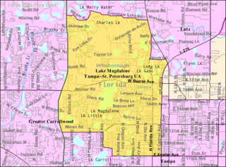
Lake Magdalene is a census-designated place (CDP) in Hillsborough County, Florida, United States. It is part of the Tampa Bay area. The population was 30,742 at the 2020 census.

<span class="mw-page-title-main">Druid Hills, Georgia</span> Neighborhood of Atlanta, Georgia, United States

Druid Hills is a community which includes both a census-designated place (CDP) in unincorporated DeKalb County, Georgia, United States, as well as a neighborhood of the city of Atlanta. The CDP's population was 14,568 at the 2010 census. The CDP formerly contained the main campus of Emory University and the Centers for Disease Control and Prevention (CDC) however they were annexed by Atlanta in 2018. The Atlanta-city section of Druid Hills is one of Atlanta's most affluent neighborhoods with a mean household income in excess of $238,500.

New Suburb Beautiful is a small neighborhood within the Hyde Park district of Tampa, Florida. As of the 2010 census the neighborhood had a population of 921. The ZIP Code neighborhood is 33629.

East Tampa is a district within the city limits of Tampa, Florida. As of the 2010 census the neighborhood had a population of 16,355. The ZIP Codes serving the neighborhood are 33605 and 33610. The district is about four miles northeast of Downtown Tampa.

Southeast Seminole Heights is a neighborhood within the Seminole Heights district of Tampa, Florida. As of the 2000 census the neighborhood had a population of 3,384. The ZIP Code of the neighborhood is 33603.

Drew Park is a neighborhood within the city limits of Tampa, Florida. As of the 2010 census the neighborhood had a population of 1,780. The ZIP Codes serving the neighborhood are 33607 and 33614.

Sunset Park is a neighborhood within the city limits of Tampa, Florida. As of the 2000 census the neighborhood had a population of 3,520. The ZIP Code serving the neighborhood is 33629.

Northview Hills is a neighborhood within the city limits of Tampa, Florida. As of the 2010 census the neighborhood had a population of 938. The ZIP Code serving the neighborhood is 33610.

Marina Club or Marina Club of Tampa is a gated residential condominium neighborhood located along the Hillsborough River within the city limits of Tampa, Florida.

Riverside Heights is a neighborhood within the city limits of Tampa, Florida. As of the 2000 census the neighborhood had a population of 2,949. The ZIP Codes serving the area are 33602, 33603 and 33607.

South Seminole Heights is a neighborhood within the city limits of Tampa, Florida. As of the 2000 census the neighborhood had a population of 3,177. The ZIP Code serving the area is 33603.

Virginia Park is a neighborhood within the city limits of Tampa, Florida. As of the 2000 census the neighborhood had a population of 4,378. The ZIP Codes serving the area are 33611 and 33629.

Lowry Park Central is a neighborhood within the city limits of Tampa, Florida. As of the 2010 census the neighborhood had a population of 3,125. The ZIP Codes serving the neighborhood are 33603 and 33604. The district includes ZooTampa at Lowry Park.

Highland Pines near Prescott in Yavapai County, Arizona, United States

Swann Estates is a neighborhood within the city limits of Tampa, Florida. As of the 2000 census the neighborhood had a population of 1,491. The ZIP Codes serving the neighborhood are 33609 and 33629.

Lowry Park North is a neighborhood within the city limits of Tampa, Florida. As of the 2010 census the neighborhood had a population of 5,936. The ZIP Codes serving the neighborhood are 33604 and 33612. The elevation is 23 feet above sea level.

Old Seminole Heights is a neighborhood within the city limits of Tampa, in the U.S. state of Florida. The neighborhood is one of three which comprise the greater Seminole Heights district within the city. As of the 2010 census the neighborhood had a population of 14,729. The ZIP Codes serving the area are 33603, 33604, and 33610.

Stoney Point is a neighborhood within the city limits of Tampa, Florida. As of the 2000 census the neighborhood had a population of 130. The ZIP code serving the area is 33629.

Cory Lake Isles is a neighborhood within the city limits of Tampa, Florida. As of the 2010 census the neighborhood had a population of 2261. The ZIP Codes serving the area are 33592 and 33647.

Bel Mar Shores is a neighborhood within the city limits of Tampa, Florida. As of the 2010 census the neighborhood had a population of 438. This neighborhood is located within the ZIP Code 33629.

References

  1. The Michaels Development Co. Portfolio - Belmont Heights Estates Archived 2007-08-19 at the Wayback Machine
  2. Housing Market Activity
  3. East Tampa project develops with help - Tampa Bay Business Journal:
  4. Newspaper Archives | tampabay.com - St. Petersburg Times
  5. Hillsborough Community Atlas Archived 2011-07-21 at the Wayback Machine
  6. "U.S. Census website". United States Census Bureau . Retrieved 2008-01-31.