
Hillsborough County is located in the west-central portion of the U.S. state of Florida. In the 2020 census, the population was 1,459,762, making it the fourth-most populous county in Florida and the most populous county outside the Miami metropolitan area. A 2021 estimate has the population of Hillsborough County at 1,512,070 people with a yearly growth rate of 1.34%, which itself is greater than the populations of 12 states according to their 2019 population estimates. Its county seat and largest city is Tampa. Hillsborough County is part of the Tampa–St. Petersburg–Clearwater Metropolitan Statistical Area.

Brandon is an unincorporated community and census-designated place (CDP) in Hillsborough County, Florida, United States. It is part of the Tampa–St. Petersburg–Clearwater Metropolitan Statistical Area. The population was 114,626 at the 2020 census, up from 103,483 at the 2010 census.
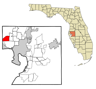
Westchase is a census-designated place (CDP) in Hillsborough County, Florida, United States. The population was 21,747 at the 2010 census, up from 11,116 at the 2000 census. The census area encompasses most of the 33626 ZIP code area.
New Tampa is a region in Florida that encompasses both a 24-square-mile (62 km2) area within the corporate limits of the City of Tampa, as well as a larger land area that is in unincorporated Hillsborough, but retains a Tampa mailing address. The incorporated portion of "New Tampa" that lies within the city limits of Tampa is one of the largest city neighborhoods. The population has grown rapidly since being annexed by the city of Tampa in 1988. As of the 2000 census, the district had a population of 22,466. Many new master planned residential communities are planned or already under construction. Big-box stores are following the boom in population and are transforming this once rural area.
Fair Oaks-Manhattan Manor is a neighborhood within the city limits of Tampa, Florida. As of the 2010 census, the neighborhood had a population of 3,953. The ZIP Code serving the neighborhood is 33611.
Live Oaks Square is a neighborhood within the city limits of Tampa, Florida. As of the 2010 census the neighborhood had a population of 2,005. The ZIP Code serving the neighborhood is 33610.
Woodland Terrace is a neighborhood within the city limits of Tampa, Florida. As of the 2000 census the neighborhood had a population of 959. The ZIP Code serving the neighborhood is 33610.
Northeast Macfarlane is a neighborhood within the city limits of Tampa, Florida. As of the 2010 census the neighborhood had a population of 8,554. The ZIP Code serving the neighborhood is 33607.
Virginia Park is a neighborhood within the city limits of Tampa, Florida. As of the 2000 census the neighborhood had a population of 4,378. The ZIP Codes serving the area are 33611 and 33629.
Lowry Park North is a neighborhood within the city limits of Tampa, Florida. As of the 2010 census the neighborhood had a population of 5,936. The ZIP Codes serving the neighborhood are 33604 and 33612. The elevation is 23 feet above sea level.
Old Seminole Heights is a neighborhood within the city limits of Tampa, in the U.S. state of Florida. The neighborhood is one of three which comprise the greater Seminole Heights district within the city. As of the 2010 census the neighborhood had a population of 14,729. The ZIP Codes serving the area are 33603, 33604, and 33610.
Ridgewood Park is a neighborhood within the city limits of Tampa, Florida. As of the 2000 census, the neighborhood had a population of 379. The ZIP Code serving the area is 33602.
Rattlesnake is a neighborhood and former unincorporated community located in the South Tampa district of Tampa, Florida.
Oak Park is a neighborhood within the city limits of Tampa, in the U.S. state of Florida. The ZIP Code which serves the neighborhood is 33605. The neighborhood is part of the East Tampa region and is located within District Five of the Tampa City Council.
Historic Hyde Park North is a neighborhood within the Hyde Park district of the city of Tampa, Florida. As of the 2010 census the neighborhood had a population of 2,689. The latest estimated population given was 2,447. The ZIP Code serving the neighborhood is 33606.
Harvey Heights is a neighborhood in the northern area of Tampa, Florida, which represents District 7 of the Tampa City Council. The 2000 census numbers were unavailable; however, the latest estimated population was 285.
Maryland Manor is a neighborhood in the southern area of Tampa, Florida, which represents District 4 of the Tampa City Council. The 2000 census numbers were unavailable, however, the latest estimated population was 1,616.

Macfarlane Park is a neighborhood in the West Tampa district of Tampa, Florida, which represents District 6 of the Tampa City Council. The 2000 census numbers were unavailable; however, the latest estimated population was 1,754.
Rivercrest is a neighborhood in the northern area of Tampa, Florida, which represents District 6 of the Tampa City Council. The 2000 census numbers were unavailable, however, the latest estimated population was 616.
Hyde Park Spanishtown Creek, formally West Hyde Park, is a neighborhood within the district of Hyde Park, which represents District 4 of the Tampa City Council. The 2000 census numbers were unavailable, however, the latest estimated population was 1,534 and the population density was 6,356 people per square mile.

