
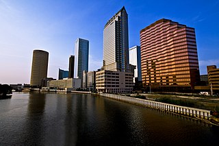
Tampa is a city on the Gulf Coast of the U.S. state of Florida. Tampa's borders include the north shore of Tampa Bay and the east shore of Old Tampa Bay. Tampa is the largest city in the Tampa Bay area and the county seat of Hillsborough County. With an estimated population of 403,364 in 2023, Tampa is the 49th-most populous city in the country and the third-most populous city in Florida after Jacksonville and Miami.
The Hillsborough River is a river located in the state of Florida in the United States. It arises in the Green Swamp near the juncture of Hillsborough, Pasco and Polk counties, and flows 60 miles (97 km) through Pasco and Hillsborough Counties to an outlet in the city of Tampa on Hillsborough Bay. It includes 4 nature trails extending for over 7 miles (11 km), making it popular among hikers. The name Hillsborough River first appeared on a British map in 1769. At the time, the Earl of Hillsborough was the British Secretary of State for the Colonies, and thus controlled the pensions of the surveyors working in the American colonies, which included East Florida.
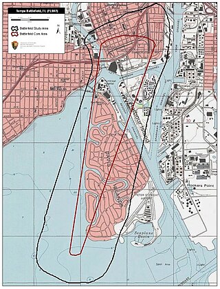
The Battle of Tampa, also known as the "Yankee Outrage at Tampa", was a minor engagement of the American Civil War fought June 30 – July 1, 1862, between the United States Navy and a Confederate artillery company charged with "protecting" the village of Tampa, Florida. Although small, Tampa's port was a key hub of trade for Central Florida, and several blockade runners from Tampa regularly slipped past the Union naval blockade that extended down the Atlantic coast around to Florida's west coast.

The first USS Seminole was a steam sloop-of-war in the United States Navy during the American Civil War.

Dale Mabry Highway is a north–south road in Tampa, Florida. The majority of its length consists of three lanes each direction plus a central turn-lane and often includes a right-turn lane. It begins at the MacDill Air Force Base entrance in South Tampa and ends by merging with US 41 just north of the Pasco County border. The highway carries multiple designations, carrying US 92 for an approximately five-mile (8.0 km) stretch between Hillsborough Avenue and Gandy Boulevard.

State Road 618, also known as the Lee Roy Selmon Expressway, and formerly known as the Crosstown Expressway, is a 14.168-mile (22.801 km) controlled-access toll road in Hillsborough County, Florida. It connects the South Tampa neighborhood near MacDill Air Force Base with Downtown Tampa and the bedroom community of Brandon. The expressway was built in stages, opening between 1976 and 1987. An approximately 1.9-mile extension to the thoroughfare's western terminus opened to traffic on Monday, April 19, 2021.

Fort Brooke was a historical military post established at the mouth of the Hillsborough River in present-day Tampa, Florida in 1824. Its original purpose was to serve as a check on and trading post for the native Seminoles who had been confined to an interior reservation by the Treaty of Moultrie Creek (1823), and it served as a military headquarters and port during the Second Seminole War (1835–1842). The village of Tampa developed just north of the fort during this period, and the area was the site of a minor raid and skirmish during the American Civil War. The obsolete outpost was sparsely garrisoned after the war, and it was decommissioned in 1883 just before Tampa began a period of rapid growth, opening the land for development.
Palma Ceia is a neighborhood located southwest of downtown Tampa, Florida in South Tampa. It is bounded by Miguel Street West of MacDill Avenue and Neptune Street East of MacDill Avenue to the north; Bay to Bay Boulevard from Dale Mabry to Himes and El Prado between Himes and the Crosstown Expressway to the south; MacDill Avenue between Neptune and San Miguel, Dale Mabry Highway between San Miguel and Bay to Bay and Himes between Bay to Bay and El Prado to the west; and the Lee Roy Selmon Expressway to the east. The street names throughout Palma Ceia are of Cuban origin, coming from streets in the old section of Havana. Historians say the most likely explanation is that Angel Cuesta, president of Cuesta-Rey cigars, shared a map of Havana with developer Thomas Palmer while discussing the area.
The modern history of Tampa, Florida, can be traced to the founding of Fort Brooke at the mouth of the Hillsborough River in today's downtown in 1824, soon after the United States had taken possession of Florida from Spain. The outpost brought a small population of civilians to the area, and the town of Tampa was first incorporated in 1855.

Florida participated in the American Civil War as a member of the Confederate States of America. It had been admitted to the United States as a slave state in 1845. In January 1861, Florida became the third Southern state to secede from the Union after the November 1860 presidential election victory of Abraham Lincoln. It was one of the initial seven slave states which formed the Confederacy on February 8, 1861, in advance of the American Civil War.
New Suburb Beautiful is a small neighborhood within the Hyde Park district of Tampa, Florida. As of the 2010 census the neighborhood had a population of 921. The ZIP Code neighborhood is 33629.

The Battle of Fort Brooke was a minor engagement fought October 16–18, 1863 in and around Tampa, Florida during the American Civil War. The most important outcome of the action was the destruction of two Confederate blockade runners which had been hidden upstream on the Hillsborough River.

USS Sagamore was a Unadilla-class gunboat built on behalf of the United States Navy for service during the American Civil War. She was outfitted as a gunboat and assigned to the Union blockade of the Confederate States of America. Sagamore was very active during the war, and served the Union both as a patrol ship and a bombardment vessel.
Gandy/Sun Bay South is a neighborhood within the city limits of Tampa, Florida. As of the 2010 census, the neighborhood had a population of 14,912. The ZIP Codes serving the area are 33611 and 33616.

The cityscape of Tampa includes historic and architecturally noteworthy structures in its downtown and residential areas. The Seminole Heights and Hyde Park neighborhoods are two of the largest historic preservation districts in Tampa.

Bayshore Beautiful is a neighborhood within the city limits of Tampa, Florida, United States. As of the 2010 census, its population was 5,931. The ZIP Codes serving the area are 33611 and 33629.
Virginia Park is a neighborhood within the city limits of Tampa, Florida. As of the 2000 census the neighborhood had a population of 4,378. The ZIP Codes serving the area are 33611 and 33629.
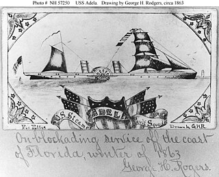
USS Adela was a steamer captured by the Union Navy during the American Civil War. She was used by the Union Navy as a gunboat in support of the Union Navy blockade of Confederate waterways.

South Tampa is a region in the city of Tampa that includes the neighborhoods of Beach Park, Ballast Point, Bayshore Beautiful, Bayshore Gardens, Bayside West, Belmar Shore, Davis Islands, Port Tampa, Fair Oaks-Manhattan Manor, Golfview, Hyde Park, New Suburb Beautiful, Virginia Park, Palma Ceia, Rattlesnake Gandy-Sun Bay South, South Westshore, parts of Sunset Park and Courier City-Oscawana. MacDill Air Force Base is also included. The region represents District 4 of the Tampa City Council. The ZIP Codes serving the area are 33606, 33608, 33609, 33611, 33616, 33621, and 33629

John Cummings Howell was an officer in the United States Navy during the American Civil War. He rose to the rank of rear admiral and late in his career was commander-in-chief of the North Atlantic Squadron and then of the European Squadron.


