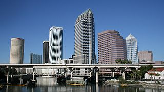
East Tampa is an unincorporated community in Hillsborough County, Florida, United States. It is partially within the census-designated place (CDP) of Gibsonton. The ZIP code for East Tampa is 33619.
The city of Tampa, Florida is officially divided into six geographical regions: New Tampa, West Tampa, Brooklyn Village, Downtown Tampa, Ybor City, and Channel District each coinciding with a respective Tampa City Council district. The neighborhoods are managed by Neighborhood and Community Relations, a department under Neighborhood Services, a city department which serves as a resource for residents and businesses.

Palmetto Beach is a neighborhood within the city limits of Tampa, Florida. As of the 2000 census the neighborhood had a population of 2,046. The ZIP Codes serving the neighborhood are 33605 and 33619. The neighborhood is located just south of the historic Ybor City.

Highland Pines is a neighborhood within the city limits of Tampa, Florida. As of the 2010 census the neighborhood had a population of 1,539. The ZIP Codes serving the neighborhood are 33605, 33610, and 33619. The neighborhood is part of the East Tampa region and is located within District Five of the Tampa City Council.

Florence Villa is a neighborhood within the city limits of Tampa, Florida. The ZIP Codes serving the neighborhood are 33605 and 33619. The neighborhood is part of the East Tampa region and is located within District Five of the Tampa City Council.

Grant Park is a neighborhood within the East Tampa district of Tampa. As of the 2010 census the neighborhood had a population of 1,840. The ZIP Codes serving the area are 33610 and 33619.

Lowry Park North is a neighborhood within the city limits of Tampa, Florida. As of the 2010 census the neighborhood had a population of 5,936. The ZIP Codes serving the neighborhood are 33604 and 33612. The elevation is 23 feet above sea level

Beasley is a neighborhood within the city limits of Tampa, Florida. The estimated population stands at 122. The neighborhood is part of the East Tampa region and is located within District Five of the Tampa City Council.

Oak Park is a neighborhood within the city limits of Tampa, in the U.S. state of Florida. The ZIP Code which serves the neighborhood is 33605. The neighborhood is part of the East Tampa region and is located within District Five of the Tampa City Council.

Orient Park is an unincorporated community in Hillsborough County, Florida, United States. Along with East Lake, it is a part of the census-designated place (CDP) of East Lake-Orient Park. The ZIP code for the community is 33619.

Lake Fern is an unincorporated community in Hillsborough County, Florida, United States. Although a separate community, it is a part of the census-designated place (CDP) of Keystone. The ZIP code for the community is 33556. In 2000, it was part of the Citrus Park-Fern Lake [sic] census county division (CCD), which recorded an estimate population of 117,574 in 2007.

Historic Hyde Park North is a neighborhood within the Hyde Park district of the city of Tampa, Florida. As of the 2010 census the neighborhood had a population of 2,689. The latest estimated population given was 2,447. The ZIP Code serving the neighborhood is 33606.

Eastern Heights is a neighborhood within the district of East Tampa, which represents District 5 of the Tampa City Council. The 2000 census numbers are included with East Tampa. The latest estimated population was 192 and the population density was 2,730 people per square mile.

Harvey Heights is a neighborhood in the northern area of Tampa, Florida, which represents District 7 of the Tampa City Council. The 2000 census numbers were unavailable; however, the latest estimated population was 285.

Tampa Overlook is a neighborhood in the North Tampa section of Tampa, which represents District 7 of the Tampa City Council. The 2000 census numbers were unavailable; however, the latest estimated population was 1,877 and the population density was 4,904 people per square mile.

Maryland Manor is a neighborhood in the southern area of Tampa, Florida, which represents District 4 of the Tampa City Council. The 2000 census numbers were unavailable, however, the latest estimated population was 1,616.

Fern Cliff is a neighborhood in the Sulphur Springs section of Tampa, Florida, which represents District 5 of the Tampa City Council. The 2000 census numbers were unavailable, however, the latest estimated population was 1,083.

Macfarlane Park is a neighborhood in the West Tampa district of Tampa, Florida, which represents District 6 of the Tampa City Council. The 2000 census numbers were unavailable, however, the latest estimated population was 1,754.

Rivercrest is a neighborhood in the northern area of Tampa, Florida, which represents District 6 of the Tampa City Council. The 2000 census numbers were unavailable, however, the latest estimated population was 616.

West Hyde Park is a neighborhood within the district of Hyde Park, which represents District 4 of the Tampa City Council. The 2000 census numbers were unavailable, however, the latest estimated population was 1,534 and the population density was 6,356 people per square mile.


