Davis Islands (Tampa)

Last updated
Davis Islands
USA Florida location map.svg
Red pog.svg
Davis Islands
Location within the state of Florida
Coordinates: 27°55′19″N82°27′20″W / 27.92194°N 82.45556°W / 27.92194; -82.45556 Coordinates: 27°55′19″N82°27′20″W / 27.92194°N 82.45556°W / 27.92194; -82.45556
Country United States
State Florida
County Hillsborough
City Tampa
Population
 (2010)
  Total5,474
Time zone UTC-5 (Eastern (EST))
  Summer (DST) UTC-4 (EDT)

Davis Islands is a Tampa neighborhood and archipelago on two (formerly three) islands in Hillsborough County, Florida. Its proximity to Downtown Tampa and its views of the Port of Tampa have made it a popular area to live. The area's population was 5,474 at the 2010 census. [1]

Contents

About Davis Islands

Palace of Florence Apartments on Davis Islands Palace of florence apts davis island.jpg
Palace of Florence Apartments on Davis Islands
Villa de Leon Villa de Leon.jpg
Villa de Leon

Davis Islands is also home to Peter O. Knight Airport and Davis Island Yacht Club. Also on the Islands are the Marjorie Park Municipal Yacht Basin & Marjorie Park at 115 Columbia Drive and the Seaplane Basin just South of the Airport. Marjorie Park was donated to the City of Tampa and named by Davis after his wife Marjorie Merritt Davis.

With a canal fully separating a portion of the island from the rest of it, Davis Islands is technically an archipelago, hence the plural form "Islands" in its name. Originally, Davis Islands consisted of three islands. With the construction of the airport, however, the end of one canal was filled in to make enough land area for a runway, connecting the two largest islands at their southern ends and reducing the archipelago's island count to two.

Nearly all streets on the island are named after bodies of water or islands. They are loosely arranged in alphabetical order, beginning with Adalia Avenue (the first street crossed after arriving on the island from the only bridge that connects it to the mainland) and ending with Severn Avenue, the street farthest away from the bridge that leads to the main island's southernmost point, on which the Davis Island Yacht Club is situated. There are no traffic lights on Davis Islands.

History

Davis Islands was built upon two man-made islands atop two small natural islands formerly known as "Little Grassy Key" and "Big Grassy Key" at the mouth of the Hillsborough River. [2] The islands were built from mud dredged from the bottom of Tampa Bay in the 1920s and expanded. This dredge-and-fill operation was undertaken at the height of the Florida Land Boom by developer and Tampa native D. P. Davis. Davis then purchased all the dredged land for $350,000. He planned a resort community with three hotels, nine-hole golf course, airport, and swimming pool. D.P. Davis then sold 306 of the original lots for $1,683,582. The development stalled when the Florida land boom of the early 1920s wound down, and Davis was mysteriously lost at sea while making a transatlantic voyage in October 1926. [3]

Many of the original Mediterranean-style structures are still standing and have received national Historic Designation, as well as local protections. Buildings of note include the Palace of Florence and Mirasol. Today Davis Islands is a mix of residential and retail areas. Most predominant today is an eclectic mix of architectural styles because of the slowdown in development in the 1930s.

Business District

East Davis Boulevard is the commercial area of the neighborhood. Along several blocks there are restaurants, cafes, bars, and shops in a tranquil sidewalk setting. The area is also very pet-friendly due to the pedestrian nature of the island. [4] [5] [6] [7] [8]

Tampa General Hospital is located at the northern tip of the Islands. It functions as the area's largest tertiary referral center, Level I Trauma center and teaching hospital affiliated with the University of South Florida Colleges of Medicine and Nursing. Criticism has long been directed at regional planners for maintaining a facility of its importance during various public emergencies having been located and expanded upon where hurricanes and rising water (in what is designated an 'A' Flood zone) could, and have, resulted in the facility's evacuation. [9]

Recreational facilities

The Davis Islands Trail linear park was completed in 2010, with amenities such as benches and water fountains. The 10-foot-wide asphalt trail is 1.3 miles and runs from Channel Drive and Davis Boulevard to the parking lot at Peter O. Knight Airport. In 2014, the Roy Jenkins Pool reopened after a $2.5 million renovation. The 85-year-old building at 154 Columbia Drive has two pools, one with five swim lanes extending 75 feet and the other kiddie-sized. Other sports facilities include the Sandra W. Freedman Tennis Complex and an array of softball fields at Davis Islands Park.

Famous residents

Derek Jeter built a 30,875-square-foot (2,868.4 m2), seven-bedroom, nine-bathroom waterfront home in the vicinity, drawing comparisons to an aircraft carrier. The home dwarfs other nearby homes and is the largest home in the Tampa area. [10] Other notable neighborhood residents include Tampa Bay Buccaneers quarterback Tom Brady, former NFL player Brad Culpepper, former Tampa Bay Lightning captain Vincent Lecavalier, Lightning players Steven Stamkos and Victor Hedman, former New York Yankees player Tino Martinez, and former Tampa mayor Bob Buckhorn. [11] [12] [13]

Demographics

Source: Hillsborough County Atlas

As of the census [14] of 2010, there were 5,747 people and 2,577 households residing in the neighborhood. The population density was 4,029/mi2. The racial makeup of the neighborhood was 93% White, 2% African American, less than 1% Native American, 3% Asian, 1% from other races, and 2% from two or more races. Hispanic or Latino of any race were 11% of the population.

There were 2,577 households, out of which 24% had children under the age of 18 living with them, 44% were married couples living together, 7% had a female householder with no husband present, and 8% were non-families. 39% of all households were made up of individuals.

In the neighborhood the population was spread out, with 21% under the age of 18, 17% from 18 to 34, 23% from 35 to 49, 24% from 50 to 64, and 15% who were 65 years of age or older. For every 100 females, there were 98.4 males.

The per capita income for the neighborhood was $48,870. About 3% of the population were below the poverty line.

See also

Adjacent Neighborhoods

Related Research Articles

<span class="mw-page-title-main">St. Petersburg, Florida</span> City in Pinellas County, Florida, United States

St. Petersburg is a city in Pinellas County, Florida, United States. As of the 2020 census, the population was 258,308, making it the fifth-most populous city in Florida and the second-largest city in the Tampa Bay Area, after Tampa. It is the largest city in the state that is not a county seat. Along with Clearwater, these cities are part of the Tampa–St. Petersburg–Clearwater Metropolitan Statistical Area, the second-largest in Florida with a population of around 2.8 million. St. Petersburg is on the Pinellas peninsula between Tampa Bay and the Gulf of Mexico, and is connected to mainland Florida to the north.

<span class="mw-page-title-main">Tampa, Florida</span> City in Florida, United States

Tampa is a city on the Gulf Coast of the U.S. state of Florida. The city's borders include the north shore of Tampa Bay and the east shore of Old Tampa Bay. Tampa is the largest city in the Tampa Bay area and the seat of Hillsborough County. With a population of 384,959 according to the 2020 census, Tampa is the third-most populated city in Florida after Jacksonville and Miami and is the 52nd most populated city in the United States.

<span class="mw-page-title-main">Tampa Bay</span> Estuary and natural harbor in Florida, off the Gulf of Mexico

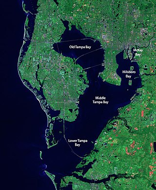
Tampa Bay is a large natural harbor and shallow estuary connected to the Gulf of Mexico on the west-central coast of Florida, comprising Hillsborough Bay, McKay Bay, Old Tampa Bay, Middle Tampa Bay, and Lower Tampa Bay. The largest freshwater inflow into the bay is the Hillsborough River, which flows into Hillsborough Bay in downtown Tampa. Many other smaller rivers and streams also flow into Tampa Bay, resulting in a large watershed area.

<span class="mw-page-title-main">Peter O. Knight Airport</span> Airport in Tampa, United States of America

Peter O. Knight Airport is an airport on Davis Islands, five minutes from downtown Tampa, Florida. Built as a Works Progress Administration project, it was Tampa's main airport from 1935 to 1945, and is still used by general aviation operators today because of its proximity to the central city. The airport was named for prominent attorney and businessman Peter O. Knight, namesake of Holland & Knight.

<span class="mw-page-title-main">Tampa Bay area</span> Region in Florida, United States

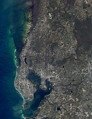
The Tampa Bay area is a major populated area surrounding Tampa Bay on the west coast of Florida in the United States. It includes the main cities of Tampa, St. Petersburg, and Clearwater. It is the 18th largest metropolitan area in the United States, with a population of 3,175,275 as of the 2020 U.S. Census.

Tampa Heights is one of the oldest neighborhoods within the city limits of Tampa, situated in the central part of the city. As of the 2000 census, the neighborhood had a population of 16,393.

<span class="mw-page-title-main">Ballast Point (Tampa)</span> Neighborhood in Hillsborough, Florida, United States

Ballast Point is a neighborhood located in the city of Tampa, county of Hillsborough, and the U.S. state of Florida. It is bordered by Hillsborough Bay, a section of the larger Tampa Bay. The ZIP code serving the area is 33611. The boundaries are Gandy Blvd. to the north, MacDill Air Force Base to the south, Hillsborough Bay to the east and S. MacDill Ave. to the west. Also included are the homes and businesses on the west side of the street of S. MacDill Ave., Gadsden Park on S. MacDill Ave. and the adjacent ELAPP Property which is part of the South Tampa Greenway.

<span class="mw-page-title-main">Hyde Park (Tampa)</span> Neighborhood in Hillsborough, Florida, United States

Hyde Park is a historic neighborhood and district within the city limits of Tampa. It includes Bayshore Boulevard, Hyde Park Village and SoHo. Its ZIP code is 33606. Hyde Park includes many historic homes and bungalows. Its history and proximity to downtown Tampa make it a desirable residential neighborhood. Because of its convenient location, developments are being built in Hyde Park. Construction includes an expansion of Hyde Park Village, an upscale shopping and dining destination, as well as multifamily residential developments.

Palma Ceia is a neighborhood located southwest of downtown Tampa, Florida in South Tampa. It is bounded by Miguel Street West of MacDill Avenue and Neptune Street East of MacDill Avenue to the north; Bay to Bay Boulevard from Dale Mabry to Himes and El Prado between Himes and the Crosstown Expressway to the south; MacDill Avenue between Neptune and San Miguel, Dale Mabry Highway between San Miguel and Bay to Bay and Himes between Bay to Bay and El Prado to the west; and the Lee Roy Selmon Expressway to the east. The street names throughout Palma Ceia are of Cuban origin, coming from streets in the old section of Havana. Historians say the most likely explanation is that Angel Cuesta, president of Cuesta-Rey cigars, shared a map of Havana with developer Thomas Palmer while discussing the area.

Port Tampa is a neighborhood in the southwestern most portion within the city limits of Tampa, Florida, on the western end of the Interbay Peninsula where the main port used to be. Within this neighborhood is Picnic Island Park as well as West Shore Elementary school.

Seminole Heights is a historic neighborhood and district located in central Tampa. It includes many early 20th century bungalow homes and historic buildings. It was an early residential area of Tampa connected by streetcar. The area had an economic downturn in the late 20th century marked by increased crime, but has since seen a resurgence with new restaurants, brew pubs and independent businesses opening up. The neighborhood's historic homes, eclectic shops and gourmet restaurants are an increasing draw.

<span class="mw-page-title-main">Courtney Campbell Causeway</span> Bridge in Florida, United States of America

The Courtney Campbell Causeway is the northernmost bridge across Old Tampa Bay, carrying State Road 60 between Clearwater, Florida in Pinellas County and Tampa, Florida in Hillsborough County.

The modern history of Tampa, Florida, can be traced to the founding of Fort Brooke at the mouth of the Hillsborough River in today's downtown in 1824, soon after the United States had taken possession of Florida from Spain. The outpost brought a small population of civilians to the area, and the town of Tampa was first incorporated in 1855.

<span class="mw-page-title-main">Downtown Tampa</span> Neighborhood in Hillsborough, Florida, United States

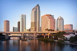
Downtown Tampa is the central business district of Tampa, Florida, United States, and the chief financial district of the Tampa Bay Area.

Drew Park is a neighborhood within the city limits of Tampa, Florida. As of the 2010 census the neighborhood had a population of 1,780. The ZIP Codes serving the neighborhood are 33607 and 33614.

Tampa Palms is a neighborhood within the New Tampa district of the city of Tampa, Florida. As of the 2010 census the neighborhood had a population of 13,515. The ZIP Codes serving the neighborhood are 33559, 33592, 33613, 33617, 33637, and 33647.

<span class="mw-page-title-main">Tampa City Council</span> Municipal government of Tampa City

The Tampa City Council is the legislative body of the municipal government of the U.S. city of Tampa, in Hillsborough County, Florida. The City Council consists of seven members, each representing one of seven corresponding districts from which they were elected. City Council, as the city's legislative branch, is responsible for enacting ordinances and resolutions administered by the corresponding executive branch, the Mayor of Tampa.

<span class="mw-page-title-main">Cityscape of Tampa, Florida</span>

The cityscape of Tampa includes historic and architecturally noteworthy structures in its downtown and residential areas. The Seminole Heights and Hyde Park neighborhoods are two of the largest historic preservation districts in Tampa.

Harbour Island is an island neighborhood within the city limits of Tampa, Florida and the sub-district within Downtown Tampa. The ZIP Code serving the area is 33602.

<span class="mw-page-title-main">South Tampa</span> Region in Florida, United States

South Tampa is a region in the city of Tampa that includes the neighborhoods of Beach Park, Ballast Point, Bayshore Beautiful, Bayshore Gardens, Bayside West, Belmar Shore, Davis Islands, Port Tampa, Fair Oaks-Manhattan Manor, Golfview, Hyde Park, New Suburb Beautiful, Virginia Park, Palma Ceia, Rattlesnake Gandy-Sun Bay South, South Westshore, parts of Sunset Park and Courier City-Oscawana. MacDill Air Force Base is also included. The region represents District 4 of the Tampa City Council. The ZIP Codes serving the area are 33606, 33608, 33609, 33611, 33616, 33621, and 33629

References

  1. "Archived copy" (PDF). Archived from the original (PDF) on 2012-02-05. Retrieved 2006-11-12.{{cite web}}: CS1 maint: archived copy as title (link)
  2. History of Davis Islands
  3. Kite-Powell, Rodney (2003). In Search of David Paul Davis (MA thesis). University of South Florida.
  4. "CityTimes: Go dogs go". Archived from the original on 2002-06-27.
  5. "Hillsborough: Liquor squabble turns tables on Davis Islands ambience". Archived from the original on 2004-06-07.
  6. http://www.tbt.com/bars/listing.jsp?ident=7600
  7. "Counting down Tampa Bay's best bars: No. 60 to No. 41 | Guide for Guys - Tampa Strip Clubs, Cigar Bars, Wings & More". Archived from the original on 2009-06-27. Retrieved 2009-06-28.
  8. http://www.dibuzz.com/2009/09/30/anchor-bar/ [ dead link ]
  9. "Enough is enough with Tampa flooding". 4 August 2015.
  10. Richard Mullins (July 15, 2009). "Derek Jeters mansion will easily be Tampa's biggest home". The Tampa Tribune .
  11. "Floridian: He's ever the great defender". Archived from the original on 2003-06-20.
  12. "Tampa Variance Board gives Derek Jeter okay to build 6-foot fence around Davis Islands home - St. Petersburg Times". www.tampabay.com. Archived from the original on 2009-08-15.
  13. "Derek Jeter's mansion will easily be Tampa's biggest home". Archived from the original on 2009-07-18. Retrieved 2009-07-16.
  14. "U.S. Census website". United States Census Bureau . Retrieved 2008-01-31.