Seminole Heights is a historic neighborhood and district located in central Tampa. It includes many early 20th century bungalow homes and historic buildings. It was an early residential area of Tampa connected by streetcar. The area had an economic downturn in the late 20th century marked by increased crime, but has since seen a resurgence with new restaurants, brew pubs and independent businesses opening up. The neighborhood's historic homes, eclectic shops and gourmet restaurants are an increasing draw.

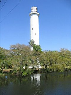
Sulphur Springs is a neighborhood and district located within the city limits of Tampa, Florida. As of the 2000 census, the neighborhood had a population of 6,308. In the late 19th century the mineral springs were a draw. In the 1940s the area was a major tourist attraction and home to a 40-foot water slide and gator farm. It is home to Sulphur Springs History and Heritage Museum.

New Suburb Beautiful is a small neighborhood within the Hyde Park district of Tampa, Florida. As of the 2010 census the neighborhood had a population of 921. The ZIP Code neighborhood is 33629.

South Nebraska is a neighborhood within the city limits Tampa, Florida. As of the 2000 census the neighborhood had a population of 2,908. The ZIP codes of the neighborhood are 33602 and 33605.

South Westshore is a neighborhood within the city limits of Tampa, Florida. As of the 2000 census the neighborhood had a population of 4,597. The ZIP Codes serving the neighborhood are 33611 and 33629. The neighborhood is located just south of the Westshore Business District.

Parkland Estates is a neighborhood within the city limits of Tampa, Florida. As of the 2000 census, the neighborhood had a population of 1,040. The ZIP Codes serving the neighborhood are 33609.

College Hill is a neighborhood within the city limits of Tampa, Florida in the United States. As of the 2010 census the neighborhood had a population of 703. However this includes only the subdivision of Belmont Heights Estates. Neighboring Ponce de Leon Estates is also part of this neighborhood The ZIP Codes serving the neighborhood are 33605 and 33610. The neighborhood is part of the East Tampa District. The neighborhood includes a new community of Belmont Heights Estates, which was built out in 2002 to replace substandard housing in the area.

Marina Club or Marina Club of Tampa is a gated residential condominium neighborhood located along the Hillsborough River within the city limits of Tampa, Florida.

Palma Ceia West is a neighborhood within the city limits of Tampa, Florida, located just west of Palma Ceia. As of the 2000 census the neighborhood had a population of 2,531. The ZIP Codes serving the neighborhood are 33609 and 33629. The neighborhood is part of the South Tampa District.

Old West Tampa is a neighborhood within the city limits of Tampa, Florida. As of the 2010 census, the neighborhood had a population of 2,014. The ZIP code serving the neighborhood is 33607. The neighborhood is located in the heart of the West Tampa district.

Southern Pines is a neighborhood within the city limits of Tampa, Florida. As of the 2000 census the neighborhood had a population of 194. The ZIP Code serving the neighborhood is 33609.

South Seminole Heights is a neighborhood within the city limits of Tampa, Florida. As of the 2000 census the neighborhood had a population of 3,177. The ZIP Code serving the area is 33603.

Virginia Park is a neighborhood within the city limits of Tampa, Florida. As of the 2000 census the neighborhood had a population of 4,378. The ZIP Codes serving the area are 33611 and 33629.

Riverbend is a neighborhood within the city limits of Tampa, Florida. As of the 2000 census the neighborhood had a population of 1,980. The ZIP Codes serving the neighborhood are 33603 and 33604.

Swann Estates is a neighborhood within the city limits of Tampa, Florida. As of the 2000 census the neighborhood had a population of 1,491. The ZIP Codes serving the neighborhood are 33609 and 33629.

Courier City-Oscawana is a neighborhood within the city limits of Tampa, Florida. As of the 2000 census the neighborhood had a population of 1,531. The ZIP Codes serving the neighborhood are 33606 and 33609.

Bayside West is a neighborhood within the city limits of Tampa, Florida. As of the 2000 census the neighborhood had a population of 1,629. The ZIP Codes serving the area are 33611 and 33629.

Eastern Heights is a neighborhood within the district of East Tampa, which represents District 5 of the Tampa City Council. The 2000 census numbers are included with East Tampa. The latest estimated population was 192 and the population density was 2,730 people per square mile.

Macfarlane Park is a neighborhood in the West Tampa district of Tampa, Florida, which represents District 6 of the Tampa City Council. The 2000 census numbers were unavailable, however, the latest estimated population was 1,754.

Rivercrest is a neighborhood in the northern area of Tampa, Florida, which represents District 6 of the Tampa City Council. The 2000 census numbers were unavailable, however, the latest estimated population was 616.


