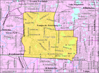
East Lake-Orient Park is an unincorporated census-designated place in Hillsborough County, Florida, United States. The population was 22,753 at the 2010 census, up from 5,703 at the 2000 census following an expansion of its borders. The area is the home of the Florida State Fairgrounds, which hosts the Florida State Fair in mid-February of each year. It was previously home to East Lake Square Mall. The East Lake Park Civic Club in conjunction with the ELP Special Dependent District (www.eastlakepark.org) manage and maintain this beautiful neighborhood. The ZIP code for East Lake-Orient Park is 33610 and 33619.

Lutz is an unincorporated census-designated place (CDP) in Hillsborough County, Florida, United States. It is fifteen miles north of Tampa. The northern part of Lutz also makes up a portion of south Pasco County. The population was 19,344 at the 2010 census.

Progress Village is a census-designated place (CDP) in Hillsborough County, Florida, United States. The population was 5,392 at the 2010 census, up from 2,482 at the 2000 census.

Carrollwood is a census-designated place (CDP) in northwestern Hillsborough County, Florida, United States. The population was 33,365 at the 2010 census. The census area includes the unincorporated communities of Carrollwood and Carrollwood Village. For the 2000 census the area was enumerated under the name "Greater Carrollwood" and had a population of 33,519. A similar area was listed as "Lake Carroll" in 1970 and 1980; for the 1990 census it was split into the smaller Carrollwood and Carrollwood Village CDPs.

Tampa Heights is one of the oldest neighborhoods within the city limits of Tampa, situated in the central part of the city. As of the 2000 census, the neighborhood had a population of 16,393.

Palmetto Beach is a neighborhood within the city limits of Tampa, Florida. As of the 2000 census the neighborhood had a population of 2,046. The ZIP Codes serving the neighborhood are 33605 and 33619. The neighborhood is located just south of the historic Ybor City.

Sulphur Springs is a neighborhood and district located within the city limits of Tampa, Florida. As of the 2000 census, the neighborhood had a population of 6,308. In the late 19th century the mineral springs were a draw. In the 1940s the area was a major tourist attraction and home to a 40-foot water slide and gator farm. It is home to Sulphur Springs History and Heritage Museum.

Live Oaks Square is a neighborhood within the city limits of Tampa, Florida. As of the 2010 census the neighborhood had a population of 2,005. The ZIP Code serving the neighborhood is 33610.

East Tampa is a district within the city limits of Tampa, Florida. As of the 2010 census the neighborhood had a population of 16,355. The ZIP Codes serving the neighborhood are 33605 and 33610. The district is about four miles northeast of Downtown Tampa.

Terrace Park is a neighborhood within the city limits of Tampa, Florida, United States. As of the 2000 census the neighborhood had a population of 7,579. The ZIP Codes serving the neighborhood are 33612 and 33617.

University Square is a neighborhood within the city limits of Tampa, Florida. As of the 2000 census the neighborhood had a population of 7,456. The ZIP Code serving the neighborhood is 33612. The neighborhood is close to many attractions and the University of South Florida.

North Tampa is a neighborhood within the city limits of Tampa, Florida. As of the 2010 census the neighborhood had a population of 5,585. The ZIP Codes neighborhood are 33604 and 33612.

Woodland Terrace is a neighborhood within the city limits of Tampa, Florida. As of the 2000 census the neighborhood had a population of 959. The ZIP Code serving the neighborhood is 33610.

North Hyde Park is a neighborhood within the city limits of Tampa, Florida. As of the 2010 census the neighborhood had a population of 1,770. The ZIP Codes serving the neighborhood are 33606, 33607 and 33609.

North Bon Air is a neighborhood within the city limits of Tampa, Florida, USA. As of the 2010 census the neighborhood had a population of 1,098. The ZIP Codes serving the area are 33607 and 33609.

Black Pearl is a neighborhood of the city of New Orleans. A subdistrict of the Uptown/Carrollton Area, its boundaries as defined by the City Planning Commission are: South Carrollton Avenue and St. Charles Avenue to the north, Lowerline, Perrier and Broadway Streets to the east, and the Mississippi River to the west.

Lowry Park Central is a neighborhood within the city limits of Tampa, Florida. As of the 2010 census the neighborhood had a population of 3,125. The ZIP Codes serving the neighborhood are 33603 and 33604. The district includes ZooTampa at Lowry Park.

Ridgewood Park is a neighborhood within the city limits of Tampa, Florida. As of the 2000 census the neighborhood had a population of 379. The ZIP Codes serving the area are 33602 and 33607.

Harvey Heights is a neighborhood in the northern area of Tampa, Florida, which represents District 7 of the Tampa City Council. The 2000 census numbers were unavailable; however, the latest estimated population was 285.

Tampa Overlook is a neighborhood in the North Tampa section of Tampa, which represents District 7 of the Tampa City Council. The 2000 census numbers were unavailable; however, the latest estimated population was 1,877 and the population density was 4,904 people per square mile.


