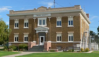
Deuel County is a county located in the U.S. State of Nebraska. As of the 2020 United States Census, the population was 1,838. Its county seat is Chappell. The county was formed in 1889 and named for Harry Porter Deuel, superintendent of the Union Pacific Railroad.

Brandon is an unincorporated community and census-designated place (CDP) in Hillsborough County, Florida, United States. It is part of the Tampa–St. Petersburg–Clearwater Metropolitan Statistical Area. The population was 114,626 at the 2020 census, up from 103,483 at the 2010 census.

East Lake-Orient Park is an unincorporated census-designated place in Hillsborough County, Florida, United States. The population was 22,753 at the 2010 census, up from 5,703 at the 2000 census following an expansion of its borders. The area is the home of the Florida State Fairgrounds, which hosts the Florida State Fair in mid-February of each year. It was previously home to East Lake Square Mall. The ZIP code for East Lake-Orient Park is 33610 and 33619.

Lutz is an unincorporated community in Hillsborough County and Pasco County, Florida, United States, 15 miles (24 km) north of Tampa. While there is a census-designated area of Lutz, the community itself extends beyond those boundaries into other census-designated areas.

Brownsville is an unincorporated community and census-designated place (CDP) in metropolitan Miami, Florida, United States. As of the 2010 census, the population was 16,583, up from 15,313 in 2010. After three decades of population loss, Brownsville gained population for the first time in over 40 years in the 2010 US Census.

Haines City is a city in Polk County, Florida, United States. Its population was 13,174 at the 2000 census and 20,535 at the 2010 census. It is the third most populous city in Polk County. It is part of the Lakeland–Winter Haven Metropolitan Statistical Area, which, in turn, is considered part of the Tampa Bay Area.

Clayton is a city in and the seat of St. Louis County, Missouri. It borders the independent city of St. Louis. The population was 17,355 at the 2020 census. Organized in 1877, the city was named after Ralph Clayton, who donated the land for the St. Louis County courthouse.

Ybor City is a historic neighborhood just northeast of downtown Tampa, Florida, United States. It was founded in the 1880s by Vicente Martinez-Ybor and other cigar manufacturers and populated by thousands of immigrants, mainly from Cuba, Spain, and Italy. For the next 50 years, workers in Ybor City's cigar factories rolled hundreds of millions of cigars annually.
Palmetto Beach is a neighborhood within the city limits of Tampa, Florida. As of the 2000 census the neighborhood had a population of 2,046. The ZIP Codes serving the neighborhood are 33605 and 33619. The neighborhood is located just south of the historic Ybor City.

West Tampa is one of the oldest neighborhoods within the city limits of Tampa, Florida, United States. It was an independently incorporated city from 1895 until 1925, when it was annexed by Tampa.
Seminole Heights is a historic neighborhood and district located in central Tampa. It includes many early 20th century bungalow homes and historic buildings. It was an early residential area of Tampa connected by streetcar. The area had an economic downturn in the late 20th century marked by increased crime, but has since seen a resurgence with new restaurants, brew pubs and independent businesses opening up. The neighborhood's historic homes, eclectic shops and gourmet restaurants are an increasing draw.
New Suburb Beautiful is a small neighborhood within the Hyde Park district of Tampa, Florida. As of the 2010 census the neighborhood had a population of 921. The ZIP Code neighborhood is 33629.
East Tampa is a district within the city limits of Tampa, Florida. As of the 2010 census the neighborhood had a population of 16,355. The ZIP Codes serving the neighborhood are 33605 and 33610. The district is about four miles northeast of Downtown Tampa.
Carver City-Lincoln Gardens is a neighborhood within the city limits of Tampa, Florida. As of the 2010 census the neighborhood had a population of 2,204. The ZIP Codes serving the neighborhood are 33607 and 33609.

V.M. Ybor is a neighborhood within the city limits of Tampa, Florida, United States. As of the 2010 census, the neighborhood had a population of 1,743. The ZIP Codes serving the neighborhood are 33602, 33603, and 33605.
North Hyde Park is a neighborhood within the city limits of Tampa, Florida. As of the 2010 census the neighborhood had a population of 1,770. The ZIP Codes serving the neighborhood are 33606, 33607 and 33609.
East Ybor is a neighborhood within the city limits of Tampa, Florida. As of the 2010 census the neighborhood had a population of 536. The ZIP Codes serving the neighborhood is 33605. The neighborhood is located just east of the historic Ybor City.
College Hill is a neighborhood within the city limits of Tampa, Florida, in the United States. As of the 2010 census the neighborhood had a population of 703. However this includes only the subdivision of Belmont Heights Estates. Neighboring Ponce de Leon Estates is also part of this neighborhood the ZIP Codes serving the neighborhood are 33605 and 33610. The neighborhood is part of the East Tampa District. The neighborhood includes a new community of Belmont Heights Estates, which was built out in 2002 to replace substandard housing in the area.
Riverside Heights is a neighborhood within the city limits of Tampa, Florida. As of the 2000 census the neighborhood had a population of 2,949. The ZIP Codes serving the area are 33602, 33603 and 33607.

Central-Alameda is a 2.18 square miles (5.65 km2) square mile neighborhood within the South Los Angeles region of Los Angeles, California.
