Temple Crest

Last updated
Temple Crest
USA Florida location map.svg
Red pog.svg
Temple Crest
Location within the state of Florida
Coordinates: 28°1′36″N82°24′43″W / 28.02667°N 82.41194°W / 28.02667; -82.41194 Coordinates: 28°1′36″N82°24′43″W / 28.02667°N 82.41194°W / 28.02667; -82.41194
Country United States
State Florida
County Hillsborough
City Tampa
Time zone UTC-5 (Eastern (EST))
  Summer (DST) UTC-4 (EDT)

Temple Crest is a neighborhood and district located northeast of Tampa, Florida. The population was 8,621 at the 2000 census. [1]

Contents

Description

Temple Crest boundaries include 30th Street to the west, Temple Terrace to the east, Busch Blvd. to the north, and the Hillsborough River to the south. [2] Nearby attractions include Busch Gardens, a theme-park located immediately north of the neighborhood, and the University of South Florida, whose campus is located less than two miles (3 km) to the north.

History

Temple Crest was part of a 19,000-acre (77 km2) property called the Riverhills Ranch. Assembled through 1916 by Bertha Potter Palmer (Chicago and Sarasota) included Temple Crest, Temple Terrace, purchased by Mrs. Potter of Chicago in 1914. After her death her sons eventually sold the land to various developers, including D.C. Gillette who developed the world's largest orange grove, a plantation of 5,000 acres (20 km2) of Temple Orange trees. From the Palmer estate was formed Temple Terraces, Inc. (included Temple Crest) and Temple Terrace Estates, Inc.(present day Temple Terrace.)

Antique badge from the Temple Crest Fire Department Temple Crest.JPG
Antique badge from the Temple Crest Fire Department

At the time of its development, Temple Crest was viewed, at the time, as a luxury development, on par with Temple Terrace. On September 12, 1924, further sales of the land called Temple Terraces Inc. was sold to Florida Realty and Mortgage Company for $14,000 and the subdivision was re‑named Temple Crest. The subdivision remained in unincorporated Hillsborough County until it was annexed into Tampa in 1961.

The Hillsborough River

The southern boundary of Temple Crest is the Hillsborough River. (1897) At a cost of $150,000 an electrical dam is built on the river by Consumers Electric Light and Street Railway Company. The dam was located halfway between present-day 40th Street and 56th Street on the Hillsborough River (today's Temple Crest neighborhood.)

(1898) On December 13, 1898 the dam is dynamited by cattle barons angry at the loss of grazing land. They tried three times. The first on January 8, 1897,shortly after construction was completed. When the water is low, remnants of the dynamited dam can be seen.

(1898–99) TECO buys the Consumers Electric Light and Street Railway Company and builds a new electric generating dam downstream at the current sight north of Sulphur Springs.

(1899) Tampa's first water plant is built by the private Tampa Waterworks Company. It pumped well water to supply the City of Tampa until March 6, 1923, when the people voted to purchase the Waterworks plant.

(1910) Hillsborough Bay is channelized to the mouth of the Hillsborough River with the Rivers and Harbors Act of 1899. In the early 1900s the Hillsborough River watershed is heavily logged for its valuable cypress, pine and oak.6)

(1916) Bertha Potter Palmer (of Chicago and Sarasota) completes purchases of 19,000 acres (77 km2) bordering the Hillsborough River in present-day Temple Terrace, Temple Crest, Terrace Park and the University of South Florida area. She calls her property the Riverhills Ranch, a hunting preserve where she builds a lodge and guest houses among other structures. She dies in 1918.

(1923) The city of Tampa builds a water treatment plant to utilize the water supply from the water above the dam.

(1933) In a torrential 24-hour rain, floods wash away the Tampa Electric dam. TECO does not rebuild the dam and turns to other locations for electrical generating plants.

(1944) The city of Tampa completes construction on the current dam, to be used for the purpose of containing drinking water for the city, at the site of the old TECO dam. The old Tampa Waterworks Company is abandoned.

The River Today

The Hillsborough river is home to many endangered species and several large bird rookeries exist. When local students reach sixth grade in Hillsborough County, they take a visit to the river for one to three days to learn about the ecosystem, watershed, and native Florida animals at a place called 'Natures Classroom'. The Hillsborough River dam (originally built in 1895 and since rebuilt) at Rowlett Park allows for the supply water for the City of Tampa.

SWFWMD and Tampa Bay Water erroneously refer to the river immediately above the dam as "a reservoir", when in reality, it is still the Hillsborough River. Currently, Tampa discharges 50 million barrels (7,900,000 m3) of the used water it gets from the river above the dam back into Tampa Bay, which is causing problems for flora and fauna of the Bay. Many are now pushing for Tampa, Temple Terrace, and the county to use only reclaimed water for their irrigation needs, thus greatly diminishing the water that they draw from the river. The river above the dam to roughly the 56th Street bridge passes through the neighborhood of Temple Crest. The river above the 56th Street bridge passes through the City of Temple Terrace and it is one of the more scenic portions of the river, the city has a river cleanup of their river portion twice a year. The City of Temple Terrace is currently battling SWFWMD for a minimum flow study for the middle river, similar to the study done for the lower river in 2007. The watershed area is trying to wean its over-reliance on water from the river by constructing a desalination plant and using more reclaimed water. Currently, Tampa is only using reclaimed water in limited areas of South Tampa, it is rumored that this water is not filtered well and contains salts that are detrimental to some plants, decreasing the desirability of the reclaimed water.

The Hillsborough River was immortalized in 1973 by author Gloria Jahoda in her book "River of the Golden Ibis".

The Middle River

The middle river, that being the portion north of the Tampa Dam at 30th Street is commonly referred to as the reservoir because it holds the drinking water for the city of Tampa. Nevertheless, it is still a part of the larger Hillsborough River which begins in the Green Swamp and flows to Tampa Bay.

Water was supplied in Tampa's early days by private wells, cisterns and tanks. Tampa's first water plant went into operation on April 20, 1899, operated by the private Tampa Waterworks Company. It pumped well water to supply the City of Tampa until March 6, 1923, when the people voted to purchase the Waterworks plant for the city.

Downstream of the 56th Street bridge in Temple Terrace, is the middle Hillsborough River, often referred to as the reservoir. The water is held behind Tampa's Water Works Dam near 30th Street. The reservoir has been Tampa's official source of water since 1944. It is about 1,300 acres (5 km2) in size and can support about 1.6 billion US gallons (6,100,000 m3) of water. The Hillsborough River flooded frequently until the Tampa Bypass Canal and the Harney Canal were built, allowing excess upstream water to flow away from urban areas into the canals and to McKay Bay.

The middle Hillsborough River is a wonderfully diverse ecosystem within the larger urban area surrounding it. Orange Lake, in the Temple Crest neighborhood, is an Audubon Society bird nesting and sanctuary, is also a living wetlands.

Upstream along the banks of the Temple Terrace Park is a scene from old Florida, cypress trees dotting the watery landscape.

Yet the middle river is in trouble. Attempts by residents to stop the damage, SWFMWD (Southwest Florida Water Management District) has done little to maintain minimum water levels, instead taking water that would normally flow into the river from the Green Swamp, siphoning the water into the Bypass Canal, which send millions of gallons to the Bill Young Reservoir in south Hillsborough County. Because of these policies wildlife is disappearing and dead zones are beginning to appear along the river's shores. Without intervention, establishing minimum healthy water levels and flows, the middle Hillsborough River will continue to deteriorate.

Education

Temple Crest is served by Hillsborough County Public Schools.

See also

Related Research Articles

<span class="mw-page-title-main">Tampa, Florida</span> City in Florida, United States

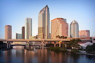
Tampa is a city on the Gulf Coast of the U.S. state of Florida. The city's borders include the north shore of Tampa Bay and the east shore of Old Tampa Bay. Tampa is the largest city in the Tampa Bay area and the seat of Hillsborough County. With a population of 384,959 according to the 2020 census, Tampa is the third-most populated city in Florida after Jacksonville and Miami and is the 52nd most populated city in the United States.

<span class="mw-page-title-main">Temple Terrace, Florida</span> City in Florida, United States

Temple Terrace is an incorporated city in northeastern Hillsborough County, Florida, United States, adjacent to Tampa. As of the 2020 census, the city had a population of 26,690. It is the third and smallest incorporated municipality in Hillsborough County. Incorporated in 1925, the community is known for its rolling landscape, bucolic Hillsborough River views, and majestic trees; it has the grandest sand live oak trees of any place in central Florida and is a Tree City USA. Temple Terrace was originally planned in the 1920s Mediterranean-Revival golf course community and is one of the first such communities in the United States.

<span class="mw-page-title-main">Raritan River</span> Major river in the U.S. state of New Jersey

Raritan River is a major river of New Jersey. Its watershed drains much of the mountainous area of the central part of the state, emptying into the Raritan Bay on the Atlantic Ocean.

<span class="mw-page-title-main">Tuolumne River</span> River from Yosemite to the San Joaquin Valley, California

The Tuolumne River flows for 149 miles (240 km) through Central California, from the high Sierra Nevada to join the San Joaquin River in the Central Valley. Originating at over 8,000 feet (2,400 m) above sea level in Yosemite National Park, the Tuolumne drains a rugged watershed of 1,958 square miles (5,070 km2), carving a series of canyons through the western slope of the Sierra. While the upper Tuolumne is a fast-flowing mountain stream, the lower river crosses a broad, fertile and extensively cultivated alluvial plain. Like most other central California rivers, the Tuolumne is dammed multiple times for irrigation and the generation of hydroelectricity.

<span class="mw-page-title-main">Tampa Bay</span> Estuary and natural harbor in Florida, off the Gulf of Mexico

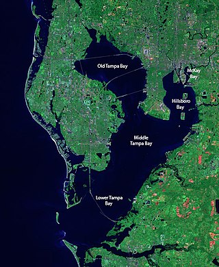
Tampa Bay is a large natural harbor and shallow estuary connected to the Gulf of Mexico on the west-central coast of Florida, comprising Hillsborough Bay, McKay Bay, Old Tampa Bay, Middle Tampa Bay, and Lower Tampa Bay. The largest freshwater inflow into the bay is the Hillsborough River, which flows into Hillsborough Bay in downtown Tampa. Many other smaller rivers and streams also flow into Tampa Bay, resulting in a large watershed area.

<span class="mw-page-title-main">Feather River</span> River in California, United States

The Feather River is the principal tributary of the Sacramento River, in the Sacramento Valley of Northern California. The river's main stem is about 73 miles (117 km) long. Its length to its most distant headwater tributary is just over 210 miles (340 km). The main stem Feather River begins in Lake Oroville, where its four long tributary forks join—the South Fork, Middle Fork, North Fork, and West Branch Feather Rivers. These and other tributaries drain part of the northern Sierra Nevada, and the extreme southern Cascades, as well as a small portion of the Sacramento Valley. The total drainage basin is about 6,200 square miles (16,000 km2), with approximately 3,604 square miles (9,330 km2) above Lake Oroville.

<span class="mw-page-title-main">Hillsborough River (Florida)</span> River in the United States of America

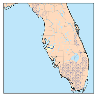
The Hillsborough River is a river located in the state of Florida in the United States. It arises in the Green Swamp near the juncture of Hillsborough, Pasco and Polk counties, and flows 60 miles (97 km) through Pasco and Hillsborough Counties to an outlet in the city of Tampa on Hillsborough Bay. It includes 4 nature trails extending for over 7 miles (11 km), making it perfect for hikers. The name Hillsborough River first appeared on a British map in 1769. At the time, the Earl of Hillsborough was the British Secretary of State for the Colonies, and thus controlled the pensions of the surveyors working in the American colonies, which included East Florida.

Tampa Heights is one of the oldest neighborhoods within the city limits of Tampa, situated in the central part of the city. As of the 2000 census, the neighborhood had a population of 16,393.

<span class="mw-page-title-main">Bone Valley</span>

The Bone Valley is a region of central Florida, encompassing portions of present-day Hardee, Hillsborough, Manatee, and Polk counties, in which phosphate is mined for use in the production of agricultural fertilizer. Florida currently contains the largest known deposits of phosphate in the United States.

<span class="mw-page-title-main">Nagarjuna Sagar Dam</span> Dam in Telangana and Palnadu district, Andhra Pradesh

Nagarjuna Sagar Dam is a masonry dam across the Krishna River at Nagarjuna Sagar which straddles the border between Nalgonda district in Telangana and Palnadu district in Andhra Pradesh. The dam provides irrigation water to the Nalgonda, Suryapet, Krishna, NTR, Bapatla, Eluru, Palnadu, Khammam, West Godavari, Guntur, and Prakasam districts along with electricity generation.

<span class="mw-page-title-main">Otay River</span> River in the United States of America

The Otay River is a river in southern San Diego County, California. The 25 mi (40 km) river begins at San Miguel Mountain, flows through the Upper and Lower Otay Reservoirs, and continues on between the southern part of the Chula Vista and the Otay Mesa West district of San Diego, to its river mouth on San Diego Bay.

The Tampa Bypass Canal and Palm River are a 14-mile-long (23 km) flood bypass operated by the Southwest Florida Water Management District. The canal includes several concrete flood control structures and was constructed during the 1960s and 1970s. Its purpose is to redirect flood waters from large amounts of rainfall from the Hillsborough River to Tampa Bay to prevent floodwaters reaching homes and businesses. Despite its original purpose it is now used as a drinking water source for the City of Tampa. During construction of the canal the Floridan aquifer was accidentally breached.

<span class="mw-page-title-main">Southwest Florida Water Management District</span> Regional governmental district in Florida, United States

The Southwest Florida Water Management District, is one of five regional agencies directed by Florida state law to protect and preserve water resources. Established in 1961 the agency operates and maintains several large properties and flood protection projects, sometimes with other agencies. The District's responsibilities have expanded to include managing water supply and protecting water quality and the natural systems — rivers, lakes, wetlands and associated uplands.The District's stated mission is to protect water resources, minimize flood risks and ensure the public’s water needs are met.

<span class="mw-page-title-main">Manatee River</span> River in Florida, United States

The Manatee River is a 36-mile-long (58 km) river in Manatee County, Florida. The river forms in the northeastern corner of Manatee County and flows into the Gulf of Mexico at the southern edge of Tampa Bay.

<span class="mw-page-title-main">Downtown Tampa</span> Neighborhood in Hillsborough, Florida, United States

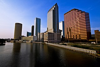
Downtown Tampa is the central business district of Tampa, Florida, United States, and the chief financial district of the Tampa Bay Area.

<span class="mw-page-title-main">Cityscape of Tampa, Florida</span>

The cityscape of Tampa includes historic and architecturally noteworthy structures in its downtown and residential areas. The Seminole Heights and Hyde Park neighborhoods are two of the largest historic preservation districts in Tampa.

Tampa Bay Water (TBW) is a regional wholesale drinking water utility that serves customers in the Tampa Bay, Florida region. The agency is a special district of the state created by inter-local agreement among six member governments. A nine-member board of directors composed of two elected commissioners from each member county and one elected representative from each member city oversees the policy decisions of the agency. The member governments that make up the board of directors are: The cities of New Port Richey, St. Petersburg, Florida, and Tampa, and Hillsborough County, Pasco County, and Pinellas County. These member governments provide water to over 2.5 million citizens.

<span class="mw-page-title-main">Molteno Dam</span> Historic dam in Cape Town, South Africa

Molteno Dam is a small but historic dam, on the lower slopes of Table Mountain in Western Cape, South Africa. Still in service, it was established in 1877 and is now located in the suburb of Oranjezicht, Cape Town.

According to the Natural Resources Defense Council's recent study, Florida is one of 14 states predicted to face "high risk" water shortages by the year 2050. The state's water is primarily drawn from the Floridan Aquifer as well as from the St. Johns River, the Suwannee River, and the Ocklawaha River. Florida's regional water conflicts stem primarily from the fact that the majority of the fresh water supply is found in the rural north, while the bulk of the population, and therefore water consumption, resides in the south. Metropolitan municipalities in central and south Florida have neared their aquifer extraction limit of 650 million US gallons (2,500,000 m3) per day, leading to the search for new, extra-regional sources.

<span class="mw-page-title-main">1757 Tampa expedition</span>

The 1757 Tampa expedition was an exploration into Tampa Bay and up the Hillsborough River led by Spanish Royal Navy captain Don Francisco Maria Celi. Documents produced during the trip include the first European-drawn map of the Tampa Bay, Florida area and a log book. The journey followed more than 200 years after Spanish Explorer Pánfilo de Narváez landed near Tampa Bay with 400 men in 1528.

References

  1. "Population by Neighborhood - Hillsborough County - 2000 Census Count" (PDF). Archived from the original (PDF) on 2012-02-05.
  2. Temple Crest – Maps Archived 2013-12-03 at the Wayback Machine