
Vancouver Island is an island in the northeastern Pacific Ocean and part of the Canadian province of British Columbia. The island is 456 km (283 mi) in length, 100 km (62 mi) in width at its widest point, and 32,100 km2 (12,400 sq mi) in total area, while 31,285 km2 (12,079 sq mi) are of land. The island is the largest by area and the most populous along the west coasts of the Americas.
The Alberni–Clayoquot Regional District of British Columbia is located on west central Vancouver Island. Adjacent regional districts it shares borders with are the Strathcona and Comox Valley Regional Districts to the north, and the Nanaimo and Cowichan Valley Regional Districts to the east. The regional district offices are located in Port Alberni.

Nanaimo—Alberni was a federal electoral district in British Columbia, Canada, that was represented in the House of Commons of Canada from 1979 to 1988. It was subsequently recreated and was represented in the House of Commons from 1997 to 2015.

Vancouver Island North is a former federal electoral district in British Columbia, Canada, that was represented in the House of Commons of Canada from 1997 to 2015.

The following is an alphabetical list of articles related to the Canadian province of British Columbia.
Comox—Alberni was a federal electoral district in British Columbia, Canada, that was represented in the House of Commons of Canada from 1917 to 1979, and again from 1988 to 1993.
Comox—Powell River was a federal electoral district in British Columbia, Canada, that was represented in the House of Commons of Canada from 1979 to 1988.
Emergency Support Services (ESS) is a component of Emergency Management British Columbia. As of March 2023, EMBC became part of the B.C. Ministry of Emergency Management and Climate Readiness ESS are those services required to preserve the well-being of people affected by an emergency or disaster. Teams are established in local municipalities and assemble together for meetings and contingency planning.

The Vancouver Island Ranges, formerly called the Vancouver Island Mountains, are a series of mountain ranges extending along the length of Vancouver Island which has an area of 31,788 km2 (12,273 sq mi). The Vancouver Island Ranges comprise the central and largest part of the island. The Geological Survey of Canada refers to Vancouver Island, Haida Gwaii, and the Alaska Panhandle as the Insular Belt including the sea floor out to 100 km (62 mi) west of Vancouver Island. The Vancouver Island Ranges are a sub-range of the Insular Mountains.
The Insular Mountains are a range of mountains in the Pacific Coast Ranges on the Coast of British Columbia, Canada, comprising the Vancouver Island Ranges and Queen Charlotte Mountains. The Insular Mountains are rugged, particularly on Vancouver Island where peaks in Strathcona Provincial Park rise to elevations of more than 2,000 m (6,562 ft). The highest of these mountains is Golden Hinde on Vancouver Island, which rises to 2,196.818 m (7,207 ft).
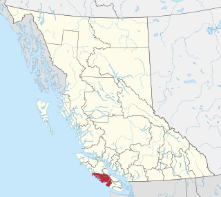
The Comox Valley Regional District is a regional district in British Columbia, Canada. It was created on February 15, 2008, encompassing the southeastern portions of the former Regional District of Comox-Strathcona, and centred about the Comox Valley. The partition left the new Comox Valley Regional District with only 8.4 percent of the former Comox-Strathcona's land area, but 57.9 percent of its population. The CVRD covers an area of 2,425 square kilometres, of which 1,725 square kilometres is land, and serves a population of 72,445 according to the 2023 Census. The district borders the Strathcona Regional District to the northwest, the Alberni-Clayoquot Regional District to the southwest, and the Regional District of Nanaimo to the southeast, as well as the qathet Regional District along the Strait of Georgia to the east.
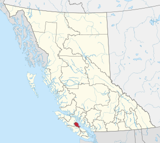
The Strathcona Regional District is a regional district in British Columbia, Canada. It was created on February 15, 2008, encompassing the northern and western portions of the former Regional District of Comox-Strathcona. The partition left the new Strathcona Regional District with 91.6 percent of the former Comox-Strathcona's land area, but only 42.1 percent of its population. Its current territory has a land area of 18,329.948 km2 and a 2016 census population of 44,671 inhabitants. There are 21 named Indian reserves within its territory, with a combined 2016 census population of 1,579 and combined land area of 16.444 km2.
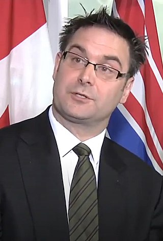
Don McRae is a Former Member of the Legislative Assembly of British Columbia, Canada, and a member of the BC Liberal Party. He was elected to the Legislative Assembly from the riding of Comox Valley in the 2009 provincial election. After serving nearly 2 years on the backbenches he was appointed Minister of Agriculture on March 14, 2011, in Premier Christy Clark's first cabinet. On September 5, 2012, he was appointed as the Minister of Education. In addition to his ministerial roles, he sat on the Environment and Land Use Committee and the Cabinet Committee on Open Government and Engagement. He introduced one piece of legislation, the Prevention of Cruelty to Animals Amendment Act, 2011.
The Comox Land District is one of the 59 land districts of British Columbia, Canada, which are part of the cadastral divisions of British Columbia, created with rest of those on Vancouver Island via the Lands Act of the Colony of Vancouver Island. The British Columbia government's BC Names system, a subdivision of GeoBC, defines a land district as "a territorial division with legally defined boundaries for administrative purposes". All land titles and surveys use the Land District system as the primary point of reference, and entries in BC Names for placenames and geographical objects are so listed.
An electoral redistribution in British Columbia was undertaken by the BC Electoral Boundaries Commission beginning in 2014 and was formalized by the passage of Bill 42, the 2015 Electoral Districts Act, during the 40th British Columbia Parliament. The act came into effect on November 17, 2015. The redistribution added two seats to the previous total, increasing the number of MLAs in the province from 85 to 87. The electoral boundaries came into effect for the 2017 election. The next redistribution is required to occur following the 2020 British Columbia general election.
