
Interstate 91 (I-91) is an Interstate Highway in the New England region of the United States. It is the primary north–south thoroughfare in the western part of the region. Its southern terminus is in New Haven, Connecticut, at I-95, while the northern terminus is in Derby Line, Vermont, at the Canada–United States border. Past the Derby Line–Rock Island Border Crossing, the road continues into Canada as Quebec Autoroute 55. I-91 is the longest of three Interstate highways whose entire route is located within the New England states and is also the only primary (two-digit) Interstate Highway in New England to intersect all five of the other highways that run through the region. The largest cities along its route, from south to north, are New Haven, Connecticut; Hartford, Connecticut; Springfield, Massachusetts; Northampton, Massachusetts; Greenfield, Massachusetts; Brattleboro, Vermont; White River Junction, Vermont; St. Johnsbury, Vermont; and Newport, Vermont.

Hartland is a town in Hartford County, Connecticut, United States. The population was 1,901 at the 2020 census. The rural town is part of the Northwest Hills Planning Region and forms the northwestern border of Hartford County. Currently, the town consists of two unincorporated areas, East and West Hartland, entirely separated by the northern portion of the Barkhamsted Reservoir. A third area, Hartland Hollow, was flooded when the reservoir was completed in 1940.

The Oak Street Connector, officially known as the Richard C. Lee Highway, is a 0.6-mile-long (0.97 km) freeway carrying State Road 724 in downtown New Haven, Connecticut, United States. The freeway begins at Orange Street and ends at the junction of Interstate 91 (I-91) and Interstate 95. The road formerly carried Route 34 until the early 2020s.
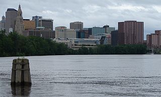
Greater Hartford is a region located in the U.S. state of Connecticut, centered on the state's capital of Hartford. It represents the only combined statistical area in Connecticut defined by a city within the state, being bordered by the Greater Boston region to the northeast and New York metropolitan area to the south and west. Sitting at the southern end of the Metacomet Ridge, its geology is characterized by land of a level grade along the shores of Connecticut River Valley, with loamy, finer-grained soil than other regions in the state. Greater Hartford, had a total population of 1,213,531 at the 2020 United States census.

Route 15 is a state highway in the U.S. state of Connecticut that runs 83.53 miles (134.43 km) from a connection with New York's Hutchinson River Parkway in Greenwich, Connecticut, to its northern terminus intersecting with Interstate 84 (I-84) in East Hartford, Connecticut. Route 15 consists of four distinct sections: the Merritt Parkway, the Wilbur Cross Parkway, most of the Berlin Turnpike, and part of the Wilbur Cross Highway. The unified designation was applied to these separate highways in 1948 to provide a continuous through route from New York to Massachusetts. The parkway section of Route 15 is often referred to locally as "The Merritt".

Route 37 is a state highway running 3.47 miles (5.58 km) in Providence County and Kent County, Rhode Island, United States. A freeway for its entire length, it serves the cities of Cranston and Warwick and is also a major east–west freeway in the Providence metropolitan area, linking T. F. Green Airport with Interstate 295. The western terminus of Route 37 is an at-grade intersection with Natick Avenue in Cranston. The freeway has numbered interchanges with I-295, Rhode Island Route 2, Pontiac Avenue, and I-95 before terminating at a trumpet interchange with U.S. Route 1 in Warwick.

Interstate 291 (I-291), also known as the Springfield Expressway, is a 5.44-mile (8.75 km) auxiliary Interstate Highway in Massachusetts that links I-91 in downtown Springfield with I-90 in Chicopee. I-291 is roughly a northeast–southwest highway. It merges with I-91 at its southwestern terminus, via a flyover. The road meets the turnpike at its northeastern terminus. Getting onto the turnpike from I-291 is straightforward, but getting from the turnpike to I-291 requires a left turn at an at-grade traffic signal. I-291 travels directly through highly populated areas of Springfield and passes under several overpasses. From its southwestern terminus to exit 5A, I-291 is concurrent with US Route 20 (US 20).

Route 9 is a 40.89-mile-long (65.81 km) expressway running from Interstate 95 (I-95) in Old Saybrook north to I-84 in Farmington. It connects the Eastern Coastline of the state along with the Lower Connecticut River Valley to Hartford and the Capital Region.

Route 25 is a 28.59-mile (46.01 km), primary state highway connecting the city of Bridgeport and the town of Brookfield in the U.S. state of Connecticut. Route 25 is a six-lane freeway from Bridgeport to northern Trumbull and a two-lane surface road the rest of the way to Brookfield.

Route 75 in the U.S. states of Connecticut and Massachusetts is a 17.5-mile-long (28.2 km) scenic route connecting the Hartford, Connecticut, and Springfield, Massachusetts, areas. The route begins at Route 159 in the town of Windsor, Connecticut, and ends at the junction of Route 159/Route 147 in the city of Agawam, Massachusetts.

Connecticut's 1st congressional district is a congressional district in the U.S. state of Connecticut. Located in the north-central part of the state, the district is anchored by the state capital of Hartford. It encompasses much of central Connecticut and includes towns within Hartford, Litchfield, and Middlesex counties.

Route 140 is a state highway in Connecticut in the northeastern part of the Greater Hartford area. Route 140 is a main artery connecting the town of Stafford to Windsor Locks.

U.S. Route 5 (US 5), a north–south United States Numbered Highway that is generally paralleled by Interstate 91 (I-91), begins at the city of New Haven in Connecticut and heads north through western Massachusetts and eastern Vermont to the international border with Canada. Within Connecticut, US 5 proceeds north from New Haven and passes through Meriden and Hartford toward Springfield, Massachusetts.

Route 219 is a state highway in northern Connecticut, running from New Hartford to Granby.
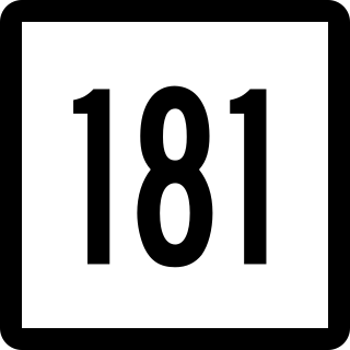
Route 181 is a rural state highway in northern Connecticut, running from Barkhamsted to Hartland.

Route 190 is a state route in the northern part of the U.S. state of Connecticut. It starts at Route 75 in the town of Suffield and proceeds eastward across the Connecticut River through the towns of Enfield, Somers, and Stafford. It ends at Route 171, in the town of Union. Route 190 was established in 1932 as a route between the state line at Southwick and the town of Enfield. The route was later extended eastward to Union but was truncated in the west to Suffield center.
The Bradley Airport Connector is a 4.6-mile (7.4 km) freeway built to connect Bradley International Airport to Interstate 91 (I-91) in Windsor Locks, Connecticut. It begins at Exit 48 of I-91 and heads west following Route 20 for about 4 miles along the town line between Windsor and Windsor Locks. The expressway then turns north, leaving Route 20 and briefly becoming an unsigned state road ending at the airport terminals.

Saville Dam is an earthen embankment dam with masonry work on the eastern branch of the Farmington River in southwestern Barkhamsted, Connecticut and central Hartland, Connecticut, dividing the latter into two villages along its hilltops, East and West Hartland. The dam is 135 ft. tall and 1,950 ft. long and has an uncontrolled spillway on its western portion. It creates the Barkhamsted Reservoir which has a volume of 36.8 billion US gallons (139,000,000 m3) and is the primary water source for Hartford, Connecticut. Connecticut Route 318, also known as Saville Dam Road, crosses over the top of the dam.
Transportation in New England encompasses the region's rail and highway networks, seaports, and airports. New England has one of the United States' oldest intercity transportation systems, which remain important to the region's economy. It is also home to the continent's first subway system. The densely populated area has many cities and towns connected by rail and road, and the larger cities each have commercial airports with daily flights to destinations outside of the region.

U.S. Route 44 (US 44) is an east–west United States Numbered Highway that runs for 237 miles (381 km) through four states in the Northeastern United States. The western terminus is at US 209 and New York State Route 55 (NY 55) in Kerhonkson, New York, a hamlet in the Hudson Valley region. The eastern terminus is at Route 3A in Plymouth, Massachusetts.


