Conzano

Last updated
Conzano
Comune di Conzano
Conzano-panorama.jpg
Location of Conzano
Conzano
Italy provincial location map 2016.svg
Red pog.svg
Conzano
Location of Conzano in Italy
Italy Piemonte location map.svg
Red pog.svg
Conzano
Conzano (Piedmont)
Coordinates: 45°1′17″N8°27′18″E / 45.02139°N 8.45500°E / 45.02139; 8.45500 Coordinates: 45°1′17″N8°27′18″E / 45.02139°N 8.45500°E / 45.02139; 8.45500
Country Italy
Region Piedmont
Province Alessandria (AL)
Frazioni San Maurizio [1]
Government
  MayorEmanuele Demaria
Area
[1]
  Total11.61 km2 (4.48 sq mi)
Elevation
262 m (860 ft)
Population
 (30 June 2017) [2]
  Total958
  Density83/km2 (210/sq mi)
Demonym(s) Conzanesi
Time zone UTC+1 (CET)
  Summer (DST) UTC+2 (CEST)
Postal code
15030
Dialing code 0142
Patron saintSaint Lucy of Syracuse
Saint day13 December
Website Official website

The Commune of Conzano (Italian: Comune di Conzano; Piemontese: Consan) is a municipality located in the south of Casale Monferrato, in the north-west of the italian province of Alessandria.
The town became famous for having been declared, in 1992, as the symbol of the massive emigration of the people to the northern Queensland, Australia, about 1890-1935 period: the ancient town square, named Piazza d'Armi (= Weapons Square), was renamed in Piazza Australia and Conzano has been twinned with Ingham, Queensland.

Contents

Geography

The town is situated on the Montferrat hills, among the Grana and Rotaldo creeks, at an altitude of 262 meters above the sea level, and includes two decentralized hamlets (the latter's formal status as a frazione ) in the northern flat side (near Casale Monferrato), recognised in the Statuto Comunale [1] ): the first one is Castello, the second one is San Maurizio. To the north-east side, the country borders with Occimiano, to the south-east with Lu e Cuccaro Monferrato, and to the west with Camagna Monferrato. The municipal territory extends over a predominantly rural area of 11.62 square kilometres (4.49 sq mi).

Ancient history

In ancient times, the site was inhabited by prehistoric settlements, followed by a Roman colonization of consul Marco Fulvio Flacco (2nd century), contemporary of Celtic-ligurian tribes named Iadatine, from the Latin Iactum, the ancient name of the Grana creek.
Since 3rd century A.D. they are documented rules of patrician praedials named Medialianus, but also Condius, Contius, accordingly the origin of toponym Contiacus, Conziacanus, Conzianus. A true urban village begins about the 5th century, at the bottom of the hill. Exposed to repeated incursions throughout the Middle Ages, especially the Lombards, Goths and Saracens, old village was totally destroyed, and the new village was built in the 10th century on the top of the hill, with a topographical structure in concentric circles, on ancient places named Pozzo Piazza and bric (= peak) Saint Lucia (= Saint Lucy of Syracuse).
The Emperor Otto I of Saxony gave the village in manor to the Lords of Cuccaro; in the same period, Marquis Oberto gift to the Cluniac congregation property for the construction of a little Benedictine Priory, and the decentralized San Maurizio hamlet began to be populated.

Clock tower & San Biagio Conzano-torre e chiesa3.jpg
Clock tower & San Biagio

Since 12th century, Conzano was dominated by the March of Montferrat, in quarrel with the Ghilini dynasty, Lords of Alessandria. Accordingly, the town was fortified, with the construction of a tower on the eastern side, called today the "Clock Tower" or "Civic Tower". About 15th century, in front of it, is built the pretty little church of San Biagio. Slightly late, is the small church of the decentralized hamlet of San Maurizio, in late Gothic style (about half of the 15th century), where it seems to be here the remains of queen Sophia, daughter of Theodore II, Marquess of Montferrat and 2nd wife of emperor John VIII Palaiologos. On the same road, it was built a small castle (nonexistent today, replaced by a recent private villa), who gave built to the current namesake hamlet. In the 16th century, the country came under the territory of the dukes Gonzaga, until the 18th century, when they were deposed.

Early modern period

Since 1709, Conzano was annexed to the Duchy of Savoy, under direct control of the Casale Monferrato district before, the Marengo department during the Napoleonic occupation. The ruins of ancient medieval structure of the village castle was remodeled in the Franciscan convent building, now at the end of the 18th century, rebuilt to house destined to a rich Count named Carlo Vidua ; The villa, which is open to the public, is particularly known for its interior decorations in the Chinese manner.
The population increased, at least until the call of the second italian war of independence (1859) and, after, the World War I. In addition, the Great Depression economic downfall in the late 9th century impoverished small rural towns. People spared the last money to travel to distant lands, for example to America, but especially to Australia. Many farmers moved from Montferrat, Italy, to the Northern Queensland, Australia, where there was a strong job demand about cutting sugar canes, a work very similar to a farming job. The poorest towns of the area were Lu, Occimiano, Cuccaro and, above all, Conzano, why there was a massive emigration, especially from this place.

Australia square Conzano-piazza Australia.jpg
Australia square

In 1992, there was a discovery of this interesting historical events, the town has been twinned with Ingham, Queensland, the opening of a thematic exhibition and a quote in memory of the official spokesman of conzanese people emigrated to Australia, Ettore Cantamessa (1892-1947).

Twin town

Conzano

Related Research Articles

Montferrat Geographic region of northern Italy

Montferrat is part of the region of Piedmont in northern Italy. It comprises roughly the modern provinces of Alessandria and Asti. Montferrat is one of the most important wine districts of Italy. It also has a strong literary tradition, including the 18th century Asti-born poet and dramatist Vittorio Alfieri and the Alessandrian Umberto Eco.

Province of Alessandria Province of Italy

The Province of Alessandria is an Italian province, with a population of some 425,000, which forms the southeastern part of the region of Piedmont. The provincial capital is the city of Alessandria.

Rainier or Renier, son of William IV, Marquis of Montferrat, was the sixth ruler of the state of Montferrat in north-west Italy from about 1100 to his death, and the first such to be identified in contemporary documents as Margrave of Montferrat.

<span class="mw-page-title-main">Casale Monferrato</span> Comune in Piedmont, Italy

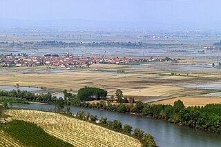
Casale Monferrato is a town in the Piedmont region of Italy, in the province of Alessandria. It is situated about 60 km (37 mi) east of Turin on the right bank of the Po, where the river runs at the foot of the Montferrat hills. Beyond the river lies the vast plain of the Po valley.

<span class="mw-page-title-main">Gabiano</span> Comune in Piedmont, Italy

Gabiano is a rural comune in the northwest of the province of Alessandria, some 25 kilometres (16 mi) west of Casale Monferrato. This area straddles the lowland immediately south of the Po and the furthest extension of the Monferrato hills. Its current population of some 1,250 has halved since mid-1930s.

<span class="mw-page-title-main">Moncalvo</span> Comune in Piedmont, Italy

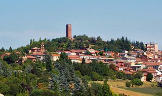
Moncalvo is a village and comune in the Province of Asti in the Italian region Piedmont, located about 45 kilometres (28 mi) east of Turin and about 15 kilometres (9 mi) northeast of Asti on the national road SS 547 which links Asti to Casale Monferrato and Vercelli. Historically it was part of the state of Montferrat and was of particular importance during the early years of the Paleologi period of the marquisate. Its best-known inhabitants were the Baroque painter Guglielmo Caccia and ‘La Bella Rosin’, King Victor Emmanuel II’s favourite mistress and eventually wife.

Montemagno is a comune (municipality) in the Province of Asti in the Italian region Piedmont, located about 50 kilometres (31 mi) east of Turin and about 13 kilometres (8 mi) northeast of Asti. As of 31 December 2010 it had a population of 1,228 and an area of 15.9 square kilometres (6.1 sq mi).

<span class="mw-page-title-main">Nizza Monferrato</span> Comune in Piedmont, Italy

Nizza Monferrato is a comune (municipality) in the Province of Asti in the Italian region of Piedmont, located about 60 kilometres (37 mi) southeast of Turin and about 20 kilometres (12 mi) southeast of Asti.

<span class="mw-page-title-main">San Marzano Oliveto</span> Comune in Piedmont, Italy

San Marzano Oliveto is a comune (municipality) in the Province of Asti in the Italian region Piedmont, located about 60 kilometres (37 mi) southeast of Turin and about 20 kilometres (12 mi) southeast of Asti.

Montiglio Monferrato is a comune in the Province of Asti in the Italian region Piedmont, located in the Valle Versa about 30 kilometres (19 mi) east of Turin and about 20 kilometres (12 mi) northwest of Asti. It was created in 1998 by combining the three communes of Colcavagno, Montiglio and Scandeluzza. The fourth principal population centre is the village of Rinco; this also was a commune in its own right until 1916 when it was absorbed by Scandeluzza.

<span class="mw-page-title-main">Camagna Monferrato</span> Comune in Piedmont, Italy

Camagna Monferrato is a comune (municipality) in the Province of Alessandria in the Italian region Piedmont, located about 60 kilometres (37 mi) east of Turin and about 20 kilometres (12 mi) northwest of Alessandria.

<span class="mw-page-title-main">Montechiaro d'Acqui</span> Comune in Piedmont, Italy

Montechiaro d'Acqui is a comune (municipality) in the Province of Alessandria in the Italian region Piedmont, located about 70 kilometres (43 mi) southeast of Turin and about 40 kilometres (25 mi) southwest of Alessandria.

<span class="mw-page-title-main">Occimiano</span> Comune in Piedmont, Italy

Occimiano is a comune (municipality) in the Province of Alessandria in the Italian region Piedmont, located about 60 kilometres (37 mi) east of Turin and about 20 kilometres (12 mi) northwest of Alessandria.

Odalengo Piccolo is a commune (comune) of the Province of Alessandria in the northwest Italian region Piedmont. It is located in the Val Cerrina about 40 kilometres (25 mi) east of Turin, about 13 kilometres (8 mi) north of Asti and some 20 kilometres (12 mi) southwest of Casale Monferrato. The municipality extends over an area of 7.63 square kilometres (2.95 sq mi) in the hills to the south of the Stura del Monferrato torrent, where areas of woodland are interspersed by vineyards. It borders on the communes of Alfiano Natta, Castelletto Merli, Cerrina Monferrato, Odalengo Grande, and Villadeati.

<span class="mw-page-title-main">Pomaro Monferrato</span> Comune in Piedmont, Italy

Pomaro Monferrato is a comune (municipality) in the Province of Alessandria in the Italian region Piedmont, located about 70 kilometres (43 mi) east of Turin and about 15 kilometres (9 mi) north of Alessandria.

San Giorgio Monferrato is a comune of the Province of Alessandria in the Italian region Piedmont. It is about 60 kilometres (37 mi) east of the regional capital Turin and about 25 kilometres (16 mi) northwest of Alessandria.

<span class="mw-page-title-main">San Salvatore Monferrato</span> Comune in Piedmont, Italy

San Salvatore Monferrato is a comune (municipality) in the Province of Alessandria in the Italian region Piedmont, located about 70 kilometres (43 mi) east of Turin and about 10 kilometres (6 mi) northwest of Alessandria.

Villanova Monferrato is a comune (municipality) in the Province of Alessandria in the Italian region Piedmont, located about 60 kilometres (37 mi) east of Turin and about 30 kilometres (19 mi) northwest of Alessandria and about 17 kilometres (11 mi) south of Vercelli. Located in the plain to the left of the Po, it the most northerly comune in the province, and borders on the comuni of Caresana, Motta de' Conti, Rive, and Stroppiana in the Vercelli, as well as those of Balzola and Casale Monferrato in the Province of Alessandria.

<span class="mw-page-title-main">Visone</span> Comune in Piedmont, Italy

Visone is a comune (municipality) in the Province of Alessandria in the Italian region Piedmont, located about 80 kilometres (50 mi) southeast of Turin and about 30 kilometres (19 mi) southwest of Alessandria. Its name becomes from the homonymous Visone creek, that flows into its territory and enters Bormida river not far from the village.

Santo Stefano is a Baroque-style, Roman Catholic church located on Piazza Santo Stefano, in Casale Monferrato, Province of Alessandria, region of Piedmont, Italy.

References

  1. 1 2 3 Statuto Comunale (2000) Archived 2008-09-08 at the Wayback Machine
  2. Most statistics are sourced from the Italian statistical institute Istat.
  3. Ambiente e cenni storici – 4, Comune di Conzano, 1998–2005, archived from the original on 2004-12-31