
Padre Island National Seashore (PINS) is a national seashore located on Padre Island off the coast of South Texas. In contrast to South Padre Island, known for its beaches and vacationing college students, PINS is located on North Padre Island and consists of a long beach where nature is preserved.

Prince Edward Island National Park is a National Park of Canada located in the province of Prince Edward Island. Situated along the island's north shore, fronting the Gulf of St. Lawrence, the park measures approximately 60 km (37 mi) in length and ranges from several hundred metres to several kilometres in width. Established in 1937, the park's mandate includes the protection of many broad sand beaches, sand dunes and both freshwater wetlands and saltmarshes. The park's protected beaches provide nesting habitat for the endangered piping plover; the park has been designated a Canadian Important Bird Area.

The piping plover is a small sand-colored, sparrow-sized shorebird that nests and feeds along coastal sand and gravel beaches in North America. The adult has yellow-orange-red legs, a black band across the forehead from eye to eye, and a black stripe running along the breast line. This chest band is usually thicker in males during the breeding season, and it is the only reliable way to tell the sexes apart. The bird is difficult to see when it is standing still, as it blends well with open, sandy beach habitats. It typically runs in short, quick spurts and then stops.

Gateway National Recreation Area is a 26,607-acre (10,767 ha) U.S. National Recreation Area in New York City and Monmouth County, New Jersey. It provides recreational opportunities that are not commonly found in a dense urban environment, including ocean swimming, bird watching, boating, hiking and camping. More than 8.7 million people visited Gateway National Recreation Area in 2022, making it the fourth-most visited unit of the National Park Service.

The Edwin B. Forsythe National Wildlife Refuge is a U.S. National Wildlife Refuge located in southern and south-central New Jersey, along the Atlantic coast, north of Atlantic City, in Atlantic and Ocean counties. The refuge was created in 1984 out of two existing refuge parcels created to protect tidal wetland and shallow bay habitat for migratory water birds. The Barnegat Division is located in Ocean County on the inland side of Barnegat Bay. The Brigantine Division is located approximately 10 miles (16 km) north of Atlantic City along the south bank of the mouth of the Mullica River. The two divisions are separated by approximately 20 miles (32 km). The refuge is located along most active flight paths of the Atlantic Flyway, making it an important link in the network of national wildlife refuges administered nationwide by the U.S. Fish and Wildlife Service. Forsythe Refuge is a part of the Hudson River/New York Bight Ecosystem and The New Jersey Coastal Heritage Trail Route. The refuge is named for Edwin B. Forsythe, conservationist Congressman from New Jersey.

Assateague Island National Seashore is a unit of the National Park Service system of the U.S. Department of the Interior. Located on the East Coast along the Atlantic Ocean in Maryland and Virginia, Assateague Island is the largest natural barrier island ecosystem in the Middle Atlantic states region that remains predominantly unaffected by human development. Located within a three-hour drive to the east and south of Richmond, Washington, Baltimore, Wilmington, Philadelphia major metropolitan areas plus north of the several clustered smaller cities around Hampton Roads harbor of Virginia with Newport News, Hampton, Norfolk, Portsmouth, Chesapeake and Virginia Beach. The National Seashore offers a setting in which to experience a dynamic barrier island and to pursue a multitude of recreational opportunities. The stated mission of the park is to preserve and protect “unique coastal resources and the natural ecosystem conditions and processes upon which they depend, provide high-quality resource-based recreational opportunities compatible with resource protection and educate the public as to the values and significance of the area”.

Perdido Key is an unincorporated community in Escambia County, Florida located between Pensacola, Florida and Orange Beach, Alabama. The community is located on and named for Perdido Key, a barrier island in northwest Florida and southeast Alabama. "Perdido" means "lost" in the Spanish and Portuguese languages. The Florida district of the Gulf Islands National Seashore includes the east end of the island, as well as other Florida islands. No more than a few hundred yards wide in most places, Perdido Key stretches some 16 miles (26 km) from near Pensacola to Perdido Pass Bridge near Orange Beach.

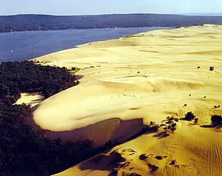
Guadalupe-Nipomo Dunes is the largest remaining dune system south of San Francisco and the second largest in the U.S. state of California. It encompasses an 18-mile (29 km) stretch of coastline on the Central Coast of California and extends from southern San Luis Obispo County to northern Santa Barbara County.

Pleasure Beach is the Bridgeport portion of a Connecticut barrier beach that extends 2.5 miles (4 km) westerly from Point No Point. Prior to June, 2014, when Pleasure Beach re-opened, the area was Connecticut's largest and most recent ghost town after it was abandoned in the late 1990s due to a fire on the bridge connecting it to the mainland. It is surrounded on three sides by water.
Bon Secour National Wildlife Refuge is a 7,157-acre (29 km2) National Wildlife Refuge located in five separate units in Baldwin and Mobile Counties, United States, directly west of Gulf Shores, Alabama on the Fort Morgan Peninsula. The refuge serves as a resting and feeding area for migratory birds and as a sanctuary for native flora and fauna. The refuge is one of the largest undeveloped parcels of land on the Alabama coast.
Silver Lake State Park is a public recreation area covering 2,936 acres (1,188 ha) that border Lake Michigan and Silver Lake, four miles (6.4 km) west of Mears in Oceana County, Michigan. The state park is composed of mature forest land and over 2,000 acres (810 ha) of sand dunes.
The Key West National Wildlife Refuge is a 189,497 acre (766.867 km2) National Wildlife Refuge located in Monroe County, Florida, between Key West, Florida and the Dry Tortugas. Only 2,019 acres (8.171 km2) of land are above sea level, on several keys within the refuge. These keys are unpopulated and are also designated as Wilderness within the Florida Keys Wilderness. The refuge was established to provide a preserve and breeding ground for native birds and other wildlife as well as to provide habitat and protection for endangered and threatened fish, wildlife, plants and migratory birds.

Reid State Park is a public recreation area overlooking the Atlantic Ocean on Georgetown Island in Sagadahoc County, Maine, United States. The 770-acre (310 ha) park is noted for its sandy beaches and sand dunes—both rare in the state of Maine—plus its rocky tidepools, salt marshes, and tidal lagoon. The park is managed by the Maine Department of Agriculture, Conservation and Forestry.

Cavendish Beach is a beach in the community of Cavendish, Prince Edward Island, Canada.

The Chincoteague National Wildlife Refuge is a 14,000-acre (57 km2) wildlife preserve operated by the U.S. Fish & Wildlife Service. It is primarily located on the Virginia half of Assateague Island with portions located on the Maryland side of the island, as well as Morris Island and Wildcat Marsh. Mostly composed of beach, dunes, marsh, and maritime forest, the refuge contains a large variety of wildlife animals and birds, including the Chincoteague Pony. The purpose of the refuge is to maintain, regulate and preserve animal and plant species as well as their habitats for present and future generations.
Sampsons Island is a 15-acre (6.1 ha) uninhabited, undeveloped barrier island at the mouth of Cotuit Harbor in Barnstable, Massachusetts. It is the location of the Massachusetts Audubon Society's Sampsons Island Wildlife Sanctuary, and it forms part of the Sampsons Island/Dead Neck Island barrier beach system. The island is only accessible by private boat, and is used for recreation and wildlife viewing and preservation.

The Amagansett National Wildlife Refuge, in Amagansett, New York, is located along the shore of the Atlantic Ocean on Long Island's south fork. The refuge is managed by the United States Fish and Wildlife Service as part of the Long Island National Wildlife Refuge Complex.

Currituck National Wildlife Refuge, located on the northern end of North Carolina's Outer Banks, was established in 1984 to preserve and protect the coastal barrier island ecosystem. Refuge lands are managed to provide wintering habitat for waterfowl and to protect endangered species such as piping plover, sea turtles, and seabeach amaranth.
The Conserve Wildlife Foundation of New Jersey (CWF) is a non profit organization based in Princeton, New Jersey and their work consists of protecting the endangered species of wildlife that live, breed, and migrate through New Jersey. CWF is a part of the Guidestar nonprofit database and provides the public with information about their organization.

Lea-Hutaff Island is a 5,641-acre (22.83 km2) uninhabited barrier island and marsh system located off the coast of North Carolina. Lea Island State Natural Area is a 25-acre (0.10 km2) North Carolina State Park on the northern end of the island.


