Cortegada Island

Last updated
Cortegada
Isla de Cortegada.pav.jpg
Cortegada island
Relief Map of Spain.png
Red pog.svg
Cortegada
Location within Spain
Spain Galicia location map.svg
Red pog.svg
Cortegada
Location within Galicia
Pontevedra-loc.svg
Red pog.svg
Cortegada
Location within the Province of Pontevedra
Geography
Location North Atlantic Ocean
Coordinates 42°37′07″N8°47′05″W / 42.61861°N 8.78486°W / 42.61861; -8.78486
Area2.5 km2 (0.97 sq mi)
Highest elevation20 m (70 ft)
Administration
Flag of Spain.svg  Spain
Autonomous community Galicia
Province Pontevedra
Demographics
Population0

Cortegada is an almost tidal island (it is possible to go walking when the lowest tides happen, but a small amount of water flow does not disappear) in a coastal inlet near Pontevedra in Galicia, Spain. It is part of the Atlantic Islands of Galicia National Park.

Contents

Location

Cortegada island is part of an archipelago that includes the Malveiras Islands or Briñas Islands, Cies, Ons, and Salvora, [1] and—the largest and the most populated one—A Illa de Arousa. Cortegada, due to its location near the mouth of the river Ulla, is sheltered from the wind within an estuary named "ría de Arousa". This and its topography give it environmental conditions more favourable to hydrophilic woodland than the other islands of the National Park.

The island is connected to the mainland via a tidal causeway, a trackway 189 metres wide covered at high tide and revealed at low tide. A track was built on the sandbar and it has stabilized a breeding ground for clams as a commercial clam hatchery. The tides in the area change quickly, and can be dangerous for pedestrians on the causeway.

History

Originally the site of a village of the municipally of O Carril (today Vilagarcía de Arousa), at the start of the 20th century, Cortegada was expropriated from its 211 tenants, on the initiative of a local businessman, with the intention of building a royal summer retreat. Offered as a present to King Alfonso XIII of Spain, who visited the island just once. in September 1907, Cortegada was sold by his son Don Juan de Borbón in 1978 to a private company. It was recently bought back by the government and added to the Atlantic Islands of Galicia National Park. The island had been inhabited until the late 19th century and used to site a monastery, hospital and leper house or lazar house. It has the remains of several stone houses, sheds and storerooms, a 17th-century stone chapel and a dock.

The island has been transformed by man. The nutrients supplied by human action created a fertile topsoil. Fertilization due to crops, livestock excrement and bird colonies has caused a change in soil composition favoring some species over others. In 2007, in a TV documentary for public television of Galicia some old people descended from islanders, recalled how the island was divided into farms and agricultural land, without tree cover. The present day laurel woods are descended from isolated examples in orchards.

Characteristics

Cortegada has an oceanic climate with warm summers, and cool mild winters. The dense moisture from the ocean is precipitating constantly. Warm moist air masses blowing off the ocean are forced upwards by the terrain, which cools the air mass to the dew point, causing the moisture in the air to condense as rain or fog, creating a habitat characterized by cool, moist conditions in the air and soil. The resulting climate is wetter and mild, with the annual oscillation of the temperature moderated by the ocean. It has two main fresh water sources: a seasonal lagoon and subterranean fresh water. This last source is peculiar since the island is surrounded by salt water, everybody can dig a well without effort even near the beach, without the need of digging further than several tens of centimetres, around ten inches at the most. The island is almost flat, its highest elevation is 22 feet high. It has an area of 54 hectares of land with a rectangle shape. Due to the large amount of water in the terrain, it flows in streams everywhere or stay quiet in ponds and puddles. The water drips, cover and soak the plants, rocks, soil, logs, moss etc. and still the water is being impassable the island during heavy rain. However the beauty of the set make it a tourist attraction.

Ecology

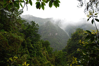
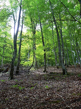
Cortegada island is valued by many researchers and scientists, as well as by the richness of its sea, for having on its north side the largest forest of bay laurel that exists in Europe. Ligustrum, Buxus, and bitter orange are some other species on Cortegada with laurel tree shape. From a distance, the island appears to be completely covered with dense woodland; it is renowned for having the last wild laurel forest of Galicia as well as a mixed population of stone pine ( Pinus pinea ) and maritime pine ( Pinus pinaster ), and a large oak forest with Quercus robur , Quercus suber , and Quercus pyrenaica . This forest formerly covered much of the coast and coastal mountains of the mainland surrounding and other Atlantic islands in the area with locally favourable wet climate microenvironments, but those forests have been much reduced in extent by logging, clearance for agriculture and grazing, and the invasion of exotic species.

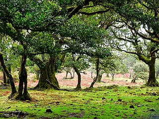
The type forests are made up of laurel-leaved evergreen hardwood trees, reaching up to 40 m in height when older. Many of the species are endemic to islands, and harbour a rich biota of understorey plants, invertebrates, some species of lizards ( Lacerta lepida , Podarcis bocagei , Chalcides striatus ), slowworms ( Anguis fragilis ), and snakes, ( Elaphe scalaris , Coronella girondica , Natrix maura ). The island has some goats and wild boars ( Sus scrofa ), wild horses lived there until recently ( Crocidura russula , Erinaceus europaeus , Talpa occidentalis ), bats ( Pipistrellus pipistrellus , Eptesicus serotinus , Rhinolophus ferrumequinum ), feral cats (Felix catus), feral mink ( Mustela vison ), rabbits, mice, rats and birds such as Iberian chiffchaff, the coal tit, the great tit, woodpecker, Eurasian wryneck, collared dove, common wood pigeon, blackbird, Scolopax rusticola , greenfinch, warbler, finch, saithe, stonechat, robin, goldfinch, wagtail, black redstart, buzzard, goshawk, and peregrine falcon. Besides many seabirds species such as cormorants and shorebirds take refuge on the island and several species of gulls nest in the breeding season.

The scrubland is formed mainly of autochthonous species, like gorse, broom, spurge flax ( Thymelaea ), rockrose (Cistaceae), sea pink ( Armeria maritima ), spiny thrift ( Armeria pungens ), Corema album, etc. Typically the marshland flora like rushes and other grow in the area of the lagoon and the ponds.

The woodland supports a diverse understorey of ferns such as Davallia canariensis (a Macaronesian epilithic fern species) and bryophytes, which require moisture for reproduction, this vegetation besides cover the ruins of the old stone houses with mosses, lichens and creepers. There are numerous herbaceous plants such as genus Sedum , Teucrium scorodonia , stinking iris ( Iris foetidissima ), Xolantha guttata , Melissa officinalis , Symphytum officinalis , Vinca difformis , Aeonium sp., Hyacinthoides sp. etc. and several species of grasses. [2]

Some evergreen climbing plants like asparagus species and Araliaceaes as Hedera helix , or Hedera iberica . Various feral fruit trees species occur, such as apple, plum and pear trees, Citrus aurantium , Vitis vinifera , common fig, hazelnut, walnut, Chesnut. The trees Salix atrocinerea , Alnus glutinosa , Platanus × hispanica Populus nigra , Ulmus, and allochthonous Cupressaceae are widespread, as are the bird-dispersed shrubs Ligustrum , honeysuckle Lonicera periclymenum , Prunus lusitanica , Prunus spinosa , Crataegus monogyna , Sorbus , Buxus , Osyris , European Mistletoe, Cornus, Taxus baccata , Ulex europaeus subsp. latebracteatus, Rubus ulmifolius, Tamus communis, and Ilex aquifolium . There are two constituent species in the genus Laurus Laurus nobilis and Laurus azorica known as Azores Laurel, a native to the laurel forests of the Azores, was also locally introduced in Cortegada Island. These recent forest are young yet with trees 18–20 m tall following the eviction of the last inhabitants. Ferns, liverworts, mosses and lichens grow up the trunks and branches. Creepers and vines complete the tangle.

A recent study found considerable genetic diversity within L. nobilis, and that L. azorica is not genetically or morphologically distinct. [3] This populations like the Cortegada Island population, famous for its large grove of laurels, come from seeds dispersed by birds but is not indigenous to the island, as this islander forest originated spontaneously from laurel specimens that were planted after the original vegetation was destroyed. The location of the Islands in the North Atlantic Ocean maintained the humid and relatively mild climate which has allowed these forests to persist to the present day, although autochthonous vegetation was almost entirely cleared for orchards, wheat fields, subsistence crops and exotic timber plantations of eucalyptus, mostly Eucalyptus globulus, pine and oak in the past. The forest regenerated easily, its decline was due to the tremendous pressure it supported.

The most common epilithic plants are Umbilicus rupestris and the ferns Polypodium interjectum and Davallia canariensis. [2] The willows are very numerous and the laurels of Cortegada live in the soils with standing water. The understorey of these Laurel forest is low, falling almost to the ground lined with ivy, along with some wood-sage plants ( Teucrium scorodonia ) and snakeroot ( Arisarum vulgare ). Willows ( Salix atrocinerea ) occupy the eastern part of the island in permanently or temporarily waterlogged soils as the only tree species, mono-specific forest, and on the west side are mixed with alder ( Alnus glutinosa ). The Marsh Vegetation provides food for the large herbivores. [2]

Related Research Articles

<span class="mw-page-title-main">Sclerophyll</span> Type of plant

Sclerophyll is a type of vegetation that is adapted to long periods of dryness and heat. The plants feature hard leaves, short internodes and leaf orientation which is parallel or oblique to direct sunlight. The word comes from the Greek sklēros (hard) and phyllon (leaf). The term was coined by A.F.W. Schimper in 1898, originally as a synonym of xeromorph, but the two words were later differentiated.

<span class="mw-page-title-main">Tasmanian temperate rainforests</span> Terrestrial ecoregion in Tasmania, Australia

The Tasmanian temperate rain forests are a temperate broadleaf and mixed forests ecoregion in western Tasmania. The ecoregion is part of the Australasian realm, which includes Tasmania and Australia, New Zealand, New Guinea, New Caledonia, and adjacent islands.

<span class="mw-page-title-main">Laurel forest</span> Type of subtropical forest

Laurel forest, also called laurisilva or laurissilva, is a type of subtropical forest found in areas with high humidity and relatively stable, mild temperatures. The forest is characterized by broadleaf tree species with evergreen, glossy and elongated leaves, known as "laurophyll" or "lauroid". Plants from the laurel family (Lauraceae) may or may not be present, depending on the location.

<i>Laurus</i> Genus of flowering plants in the laurel family Lauraceae

Laurus is a genus of evergreen trees or shrubs belonging to the laurel family, Lauraceae. The genus contains three or more species, including the bay laurel or sweet bay, L. nobilis, widely cultivated as an ornamental plant and a culinary herb.

<span class="mw-page-title-main">New Caledonia rain forests</span>

The New Caledonia rain forests are a terrestrial ecoregion, located in New Caledonia in the South Pacific. It is a tropical moist broadleaf forest ecoregion, part of the Australasian realm.

<span class="mw-page-title-main">Atlantic coastal pine barrens</span> Temperate coniferous forest ecoregion of Northeast United States

The Atlantic coastal pine barrens is a now rare temperate coniferous forest ecoregion of the Northeast United States distinguished by unique species and topographical features, generally nutrient-poor, often acidic soils and a pine tree distribution once controlled by frequent fires.

<span class="mw-page-title-main">Garajonay National Park</span>

Garajonay National Park is located in the center and north of the island of La Gomera, one of the Canary Islands (Spain). It was declared a national park in 1981 and a World Heritage Site by UNESCO in 1986. It occupies 40 km2 and it extends into each of the six municipalities on the island.

<span class="mw-page-title-main">Rías Baixas</span> Series of estuarine inlets in Galicia, Spain

The Rías Baixas are a series of four estuarine inlets located on the southwestern coast of Galicia, Spain. They are the Ría de Muros e Noia, the Ría de Arousa, the Ría de Pontevedra, and the Ría de Vigo. The northernmost Rías Baixas begin below Cape Finisterre while the southernmost rias border the Portuguese coast, taking up the southern part of the Province of Coruña and the entire Province of Pontevedra. Its capital is the city of Pontevedra. Due to unique conditions, the Rías Baixas are rich in marine life which helps the fishing and aquaculture industry of the area. Beaches, marinas, distinctive towns, and plenty of water activities also attract tourists, providing another source of income.

<span class="mw-page-title-main">Cíes Islands</span>

The Cíes Islands are an archipelago off the coast of Pontevedra in Galicia, Spain, in the mouth of the Ria de Vigo. They were declared a Nature Reserve in 1980 and are included in the Atlantic Islands of Galicia National Park created in 2002.

<i>Picconia</i> Genus of flowering plants

Picconia is a genus of two species of flowering plants in the family Oleaceae, found in the laurel forests habitat of Macaronesia.

<span class="mw-page-title-main">Forests of the Iberian Peninsula</span> Overview of forests of the Iberian Peninsula

The woodlands of the Iberian Peninsula are distinct ecosystems on the Iberian Peninsula. Although the various regions are each characterized by distinct vegetation, the borders between these regions are not clearly defined, and there are some similarities across the peninsula.

<span class="mw-page-title-main">Atlantic Islands of Galicia National Park</span>

The Atlantic Islands of Galicia National Park is the only national park located in the province of Pontevedra, in the autonomous community of Galicia, Spain. It comprises the archipelagos of Cíes, Ons, Sálvora and Cortegada. The park covers a land area of 1,200 ha and a sea area of 7,200 ha. It is the tenth most visited national park in Spain. It was the thirteenth national park to be established in Spain. Since 2021 it has been designated as a protected Ramsar site.

<i>Laurus azorica</i> Species of flowering plant in the laurel family Lauraceae

Laurus azorica, the Azores laurel or Macaronesian laurel, is a small, evergreen tree in the laurel family (Lauraceae), found only on the Azores island group in the North Atlantic.

<i>Salix atrocinerea</i> Species of willow

Salix atrocinerea, commonly called grey willow or large gray willow, is a species of willow. It is a bush or small tree up to 12 m (39 ft) tall. As a pioneer species of willow, it quickly colonizes poor soils.

<span class="mw-page-title-main">Victoria Plains tropical savanna</span> Ecoregion in Australia

The Victoria Plains tropical savanna is a tropical and subtropical grasslands, savannas, and shrublands ecoregion in northwestern Australia.

<i>Laurus novocanariensis</i> Species of flowering plant in the laurel family Lauraceae

Laurus novocanariensis is a large shrub or tree with aromatic, shiny dark-green foliage. belonging to the evergreen tree genus Laurus of the laurel family, Lauraceae. The genus includes three species, whose diagnostic key characters often overlap. Under favorable conditions it is an impressive tree of 3 to 20 m. tall. It is native of rich soils in the cloud zone of always moist spots in subtropical climate with a high air-humidity, on the Canary and Madeira islands.

<span class="mw-page-title-main">Southeastern conifer forests</span> Temperate coniferous forests ecoregion of the United States

The Southeastern conifer forests are a temperate coniferous forest ecoregion of the southeastern United States. It is the largest conifer forest ecoregion east of the Mississippi River. It is also the southernmost instance of temperate coniferous forest within the Nearctic realm.

<span class="mw-page-title-main">Madeira evergreen forests</span> Ecological zone of Madeira and nearby islands

The Madeira evergreen forests is a laurissilva ecoregion of southwestern Europe. It covers the archipelago of Madeira and some nearby islands in the Atlantic Ocean. Laurel forest, known as laurissilva, once covered the islands. Over centuries the laurel forests were mostly cleared. Madeira's remaining forests are now protected.

<span class="mw-page-title-main">Azores temperate mixed forests</span>

The Azores temperate mixed forests is a temperate broadleaf and mixed forests ecoregion of southwestern Europe. It encompasses the Azores archipelago in the Atlantic Ocean. These volcanic islands are an autonomous region of Portugal, and lie 1500 km west of the Portuguese mainland.

<span class="mw-page-title-main">Flora of Cantabria</span> Plant species of Cantabria

The flora of Cantabria is the result of three determining factors: the climate, the composition of the soil, directly dependent on the types of existing rocks, and the evolutionary history of the different plant formations.

References

  1. Iter Europe:Ilas Atlấntoas: Pontevedra.
  2. 1 2 3 http://www.parquenacionalillasatlanticas.com/spa/informacion_saber_mas.php?nar1=28 [ dead link ]
  3. Arroyo–García, R., Martínez–Zapater, J. M., Fernández Prieto, J. A., & Álvarez–Arbesú, R. (2001). "AFLP evaluation of genetic similarity among laurel populations (Laurus L.)". Euphytica. 122: 155–164. doi:10.1023/A:1012654514381. S2CID   21642932.{{cite journal}}: CS1 maint: multiple names: authors list (link)