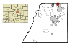
Cottonwood, Colorado | |
---|---|
Coordinates: 39°33′45″N104°48′07″W / 39.56250°N 104.80194°W [1] | |
Country | United States |
State | State of Colorado |
County | Douglas County |
County | Town of Parker |
Elevation | 1,753 m (5,752 ft) |
Population (2000) | |
• Total | 931 |
Time zone | UTC-7 (MST) |
• Summer (DST) | UTC-6 (MDT) |
Area codes | 303 & 720 |
GNIS feature ID | 1852842 [1] |
Cottonwood is a neighborhood in the Town of Parker, Colorado. A former census-designated place (CDP), the population was 931 at the 2000 census.
This climate type is usually found in the outskirts of true deserts in low-latitude, semiarid regions. It has a cooler, wetter winter resulting from the higher latitude and mid-latitude frontal cyclone activity. Annual precipitation totals are greater than in tropical and subtropical desert climates. Yearly variations in amount are not as extreme as in the true deserts but are nevertheless large. The Köppen Climate Classification subtype for this climate is "BSk". (Tropical and Subtropical Steppe Climate).
Climate data for Cottonwood, Colorado | |||||||||||||
---|---|---|---|---|---|---|---|---|---|---|---|---|---|
Month | Jan | Feb | Mar | Apr | May | Jun | Jul | Aug | Sep | Oct | Nov | Dec | Year |
Mean daily maximum °F (°C) | 43 (6) | 46 (8) | 51 (11) | 60 (16) | 69 (21) | 80 (27) | 86 (30) | 84 (29) | 77 (25) | 66 (19) | 52 (11) | 45 (7) | 63 (17) |
Mean daily minimum °F (°C) | 15 (−9) | 18 (−8) | 23 (−5) | 31 (−1) | 40 (4) | 49 (9) | 55 (13) | 54 (12) | 46 (8) | 35 (2) | 23 (−5) | 17 (−8) | 34 (1) |
Average precipitation inches (mm) | 0.3 (7.6) | 0.3 (7.6) | 0.9 (23) | 1.3 (33) | 2.5 (64) | 1.9 (48) | 2.2 (56) | 1.9 (48) | 1.1 (28) | 0.8 (20) | 0.7 (18) | 0.3 (7.6) | 14.1 (360) |
Source: Weatherbase [2] |
Douglas County is a county located in the U.S. state of Colorado. As of the 2020 Census, the population was 357,978. The county is named in honor of U.S. Senator Stephen A. Douglas. The county seat is Castle Rock.
Denver is the central city of a conurbation region in the U.S. state of Colorado. The conurbation includes one continuous region consisting of the six central counties of Adams, Arapahoe, Broomfield, Denver, Douglas, and Jefferson. The Denver region is part of the Front Range Urban Corridor and its metropolitan planning organization is the Denver Regional Council of Governments.
Arapahoe County is a county located in the U.S. state of Colorado. As of the 2020 census, its population was 655,070, making it the third-most populous county in Colorado. The county seat is Littleton, and the most populous city is Aurora. The county was named for the Arapaho Native American tribe, who once lived in the region.
The City of Northglenn is a home rule municipality located in Adams and Weld counties, Colorado, United States. Northglenn is a part of the Denver–Aurora–Lakewood, CO Metropolitan Statistical Area. As of the 2020 census the city's population was 38,131. It was built as a master planned community in 1959 by Jordon Perlmutter.
Byers is an unincorporated town, a post office, and a census-designated place (CDP) located in and governed by Arapahoe County, Colorado, United States. The CDP is a part of the Denver–Aurora–Lakewood, CO Metropolitan Statistical Area. The Byers post office has the ZIP Code 80103. At the United States Census 2020, the population of the Byers CDP was 1,322.
Castlewood is a neighborhood in the City of Centennial, Colorado. A former census-designated place (CDP), the population was 25,567 at the 2000 census. It has been a part of the City of Centennial since the city's incorporation in 2001.
The City of Englewood is a home rule municipality located in Arapahoe County, Colorado, United States. The town population was 33,659 at the 2020 United States Census. Englewood is a part of the Denver–Aurora–Lakewood, CO Metropolitan Statistical Area and the Front Range Urban Corridor. Englewood is located immediately south of Denver in the South Platte River Valley.
Southglenn is a neighborhood in the City of Centennial, Colorado. A former census-designated place (CDP), the population was 43,520 at the 2000 census.
Carriage Club is a neighborhood in the City of Lone Tree, Douglas County, Colorado, United States. A former census-designated place (CDP), the population was 1,002 at the United States Census 2000.
Heritage Hills is a neighborhood in the City of Lone Tree, Colorado. A former census-designated place (CDP), the population was 658 at the 2000 census. The Lone Tree Post Office serves the area.
Meridian is an unincorporated community and a census-designated place (CDP) located in and governed by Douglas County, Colorado, United States. The CDP is a part of the Denver–Aurora–Lakewood, CO Metropolitan Statistical Area. The population of the Meridian CDP was 4,786 at the United States Census 2020. The CDP lies in ZIP code 80112.
Parker is a home rule municipality in Douglas County, Colorado, United States. As a self-declared "town" under the home rule statutes, Parker is the second most populous town in the county; Castle Rock is the most populous. In recent years, Parker has become a commuter town at the southeasternmost corner of the Denver metropolitan area. The population was 58,512 at the 2020 census. Parker is now the 19th most populous municipality in the state of Colorado.
Stonegate is an unincorporated community and a census-designated place (CDP) located in and governed by Douglas County, Colorado, United States. The CDP is a part of the Denver–Aurora–Lakewood, CO Metropolitan Statistical Area. The population of the Stonegate CDP was 9,072 at the United States Census 2020. The Stonegate Village Metropolitan District provides services to the community, which lies in ZIP Code 80134.
The Pinery is an unincorporated community and a census-designated place (CDP) located in and governed by Douglas County, Colorado, United States. The CDP is a part of the Denver–Aurora–Lakewood, CO Metropolitan Statistical Area. The population of The Pinery CDP was 11,311 at the United States Census 2020. Douglas County governs the unincorporated community. The Parker post office serves the area.
Ponderosa Park is an unincorporated community and a census-designated place (CDP) located in and governed by Elbert County, Colorado, United States. The CDP is a part of the Denver–Aurora–Lakewood, CO Metropolitan Statistical Area. The population of the Ponderosa Park CDP was 3,334 at the United States Census 2020. Elbert County governs the unincorporated community. The Elizabeth post office serves the area.
Atwood is an unincorporated town, a post office, and a census-designated place (CDP) located in and governed by Logan County, Colorado, United States. The CDP is a part of the Sterling, CO Micropolitan Statistical Area. The Atwood post office has the ZIP Code 80722. At the United States Census 2020, the population of the Atwood CDP was 138.
Grand View Estates is an unincorporated community and a census-designated place (CDP) located in and governed by Douglas County, Colorado, United States. The CDP is a part of the Denver–Aurora–Lakewood, CO Metropolitan Statistical Area. The population of the Grand View Estates CDP was 689 at the United States Census 2020. The area lies in ZIP code 80134.
The United States Office of Management and Budget has defined the 12-county Denver–Aurora, CO Combined Statistical Area comprising the Denver–Aurora–Lakewood, CO Metropolitan Statistical Area, the Boulder, CO Metropolitan Statistical Area, and the Greeley, CO Metropolitan Statistical Area. The United States Census Bureau estimates that the population was 3,214,218 as of July 1, 2012, an increase of +3.99% since the 2010 United States Census, and ranking as the 16th most populous metropolitan combined statistical area and the 17th most populous primary statistical area of the United States. The population estimate for 2020 was 3,652,385.
The North Central Colorado Urban Area comprises the four contiguous metropolitan statistical areas in the north central region of the State of Colorado: the Denver–Aurora Metropolitan Statistical Area, the Boulder Metropolitan Statistical Area, the Fort Collins-Loveland Metropolitan Statistical Area, and the Greeley Metropolitan Statistical Area. With the exception of southeastern Elbert County, southeastern Park County, and tiny portions of southern Douglas County, the entire North Central Colorado Urban Area is drained by the South Platte River and its tributaries. The North Central Colorado Urban Area is the central, and the most populous, of the three primary subregions of the Front Range Urban Corridor.
Castle Pines is a former census-designated place (CDP) in Douglas County, Colorado, United States. The population was 3,614 at the 2010 census.