Countryside, Kansas

Last updated

Countryside, Kansas
Neighborhood
Flag of Countryside, Kansas.svg
Johnson County Kansas Incorporated and Unincorporated areas Countryside Highlighted.svg
Location of Countryside, Kansas
Coordinates: 39°0′58″N94°39′19″W / 39.01611°N 94.65528°W / 39.01611; -94.65528
Country United States
State Kansas
County Johnson
Area
  Total0.1 sq mi (0.3 km2)
  Land0.1 sq mi (0.3 km2)
  Water0.0 sq mi (0.0 km2)
Population
 (2000)
  Total295
  Density2,449.9/sq mi (945.9/km2)
Time zone UTC-6 (Central (CST))
  Summer (DST) UTC-5 (CDT)
ZIP code
66202
Area code 913
FIPS code 20-15975 [1]

Countryside was a half-mile-wide residential area in Johnson County, Kansas, USA, which was incorporated by its residents as a city on July 2, 1951, under Kansas Law. In a special election on December 3, 2002, residents voted to consolidate with the surrounding city of Mission, Kansas, in which the houses and streets had originally been built in the unincorporated Mission Township of Johnson County beginning in 1937. Countryside, as a city governmental entity, ceased to exist on January 15, 2003, however, the originally founded Countryside Homes Association, Inc. neighborhood remains active.

Contents

As a city, Countryside consisted of 133 houses of middle to upper-class value situated with Lamar Avenue on the west, West 61st Street on the north, Nall Avenue on the east and Shawnee Mission Parkway on the south. The south side of West 62nd Terrace is a parkway strip of well-kept grass and trees opening, on its far side, onto a view of West 63rd Street, which had become a divided four-lane major artery, also running in an east–west direction, through Johnson County in 1960. In 1983, the W 63rd Street, Rock Creek Pkwy, Johnson Drive (US 56 & 169) corridor was renamed Shawnee Mission Parkway to reduce confusion about the three names and multiple numbers the road carried.

Countryside was dependent on Mission, Kansas for police services, Consolidated Fire District 2 provided fire protection and it had no commercial, governmental or other non-residential buildings, except Trinity Lutheran Church, within its boundaries. Its property regulations were established by the City of Countryside ordinances and its 1937 Countryside Homes Association declarations, which were revised in 2016. Countryside was the first city to consolidate with another city in Johnson County, as opposed to being annexed, and represents the first city consolidation in Kansas, since the 1960s.

Geography

Countryside is located at 39°0′58″N94°39′19″W / 39.01611°N 94.65528°W / 39.01611; -94.65528 (39.015985, -94.655297). [2]

According to the United States Census Bureau, the city had a total area of 0.3 km2 (0.12 sq mi), all land.

Demographics

The census [1] of 2000 provides demographics for Countryside. The census states that there were 295 people, 133 households, and 91 families residing in the city. The population density was 949.2 people/km2 (2,458 people/sq mi). There were 133 housing units at an average density of 421.5 units/km2 (1,092 units/sq mi). The racial makeup of the city was 99.32% White, 0.34% Native American, and 0.34% from two or more races. Hispanic or Latino of any race were 1.02% of the population. 32.5% were German, 19.2% English, 13.6% Irish and 5.3% American ancestry according to Census 2000.

There were 133 households, out of which 27.1% had children under the age of 18 living with them, 60.5% were married couples living together, 7.0% had a female householder with no husband present, and 30.2% were non-families. 26.4% of all households were made up of individuals, and 7.0% had someone living alone who was 65 years of age or older. The average household size was 2.29 and the average family size was 2.77.

In the city the population was spread out, with 21.4% under the age of 18, 2.7% from 18 to 24, 34.6% from 25 to 44, 26.8% from 45 to 64, and 14.6% who were 65 years of age or older. The median age was 41 years. For every 100 females, there were 86.7 males. For every 100 females age 18 and over, there were 90.2 males.

The median income for a household in the city was $73,958, and the median income for a family was $88,029. Males had a median income of $49,063 versus $52,813 for females. The per capita income for the city was $37,129. About 2.7% of families and 1.0% of the population were below the poverty line, including 1.1% of those under the age of eighteen and none of those 65 or over.

Related Research Articles

<span class="mw-page-title-main">Pottawatomie County, Oklahoma</span> County in Oklahoma, United States

Pottawatomie County is a county located in the U.S. state of Oklahoma. As of the 2020 census, the population was 72,454. Its county seat is Shawnee.

<span class="mw-page-title-main">Shawnee County, Kansas</span> County in Kansas, United States

Shawnee County is located in northeast Kansas, in the central United States. Its county seat and most populous city is Topeka, the state capital. As of the 2020 census, the population was 178,909, making it the third-most populous county in Kansas. The county was one of the original 33 counties created by the first territorial legislature in 1855, and it was named for the Shawnee tribe.

<span class="mw-page-title-main">Johnson County, Kansas</span> County in Kansas, United States

Johnson County is a county in the U.S. state of Kansas, along the border of the state of Missouri. Its county seat is Olathe. As of the 2020 census, the population was 609,863, the most populous county in Kansas. The county was named after Thomas Johnson, a Methodist missionary who was one of the state's first settlers. Largely suburban, the county contains a number of suburbs of Kansas City, Missouri, including Overland Park, a principal city of and second most populous city in the Kansas City Metropolitan Area.

<span class="mw-page-title-main">Fairway, Kansas</span> City in Kansas, United States

Fairway is a city in Johnson County, Kansas, United States. It is included in the Kansas City metropolitan area census designation and the Shawnee Mission postal services designation. As of the 2020 United States census, the city population was 4,170.

<span class="mw-page-title-main">Lenexa, Kansas</span> City in Johnson County, Kansas, US

Lenexa is a city in Johnson County, Kansas, United States, and part of the Kansas City metropolitan area. As of the 2020 census, the population of the city was 57,434. making it the 9th most populated city in Kansas. It is bordered by the cities of Shawnee to the north, Overland Park to the east, De Soto to the west and Olathe to the south.

<span class="mw-page-title-main">Merriam, Kansas</span> City in Kansas, United States

Merriam is a city in Johnson County, Kansas, United States, and part of the Kansas City Metropolitan Area. As of the 2020 census, the population of the city was 11,098. Merriam is included in the Shawnee Mission postal designation. It is also the headquarters of Seaboard Corporation.

<span class="mw-page-title-main">Mission, Kansas</span> City in Kansas, United States

Mission is a city in Johnson County, Kansas, United States, and part of the Kansas City Metropolitan Area. As of the 2020 census, the population of the city was 9,954.

<span class="mw-page-title-main">Mission Hills, Kansas</span> City in Kansas, United States

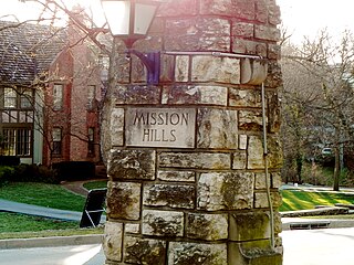
Mission Hills is a city in Johnson County, Kansas, United States, and part of the Kansas City Metropolitan Area. As of the 2020 census, the population of the city was 3,594. The east city limits is the Kansas-Missouri state line at State Line Road. Mission Hills was originally developed by noted Kansas City developer J. C. Nichols beginning in the 1920s as part of his Country Club District plan.

<span class="mw-page-title-main">Mission Woods, Kansas</span> City in Kansas, United States

Mission Woods is a city in Johnson County, Kansas, United States, and part of the Kansas City Metropolitan Area. As of the 2020 census, the population of the city was 203.

<span class="mw-page-title-main">Prairie Village, Kansas</span> City in Kansas, United States

Prairie Village is a city in Johnson County, Kansas, United States, and located within the Kansas City Metropolitan Area. As of the 2020 census, the population of the city was 22,957.

<span class="mw-page-title-main">Roeland Park, Kansas</span> City in Kansas, United States

Roeland Park is a city in Johnson County, Kansas, United States, and located within the Kansas City metropolitan area. As of the 2020 census, the population of the city was 6,871.

<span class="mw-page-title-main">Shawnee, Kansas</span> City in Kansas, United States

Shawnee is a city in Johnson County, Kansas, United States. It is the seventh most populous municipality in the Kansas City metropolitan area. As of the 2020 census, the population of the city was 67,311.

<span class="mw-page-title-main">Westwood, Kansas</span> City in Kansas, United States

Westwood is a city in northeast Johnson County, Kansas, United States. As of the 2020 census, the population of the city was 1,750. It is the second most densely populated city in the Kansas City Metropolitan Area.

<span class="mw-page-title-main">Cuba, Kansas</span> City in Republic County, Kansas

Cuba is a city in Republic County, Kansas, United States. As of the 2020 census, the population of the city was 140.

<span class="mw-page-title-main">Auburn, Kansas</span> City in Shawnee County, Kansas

Auburn is a city in Shawnee County, Kansas, United States. As of the 2020 census, the population of the city was 1,273.

<span class="mw-page-title-main">Rossville, Kansas</span> City in Shawnee County, Kansas

Rossville is a city in Shawnee County, Kansas, United States. As of the 2020 census, the population of the city was 1,105.

<span class="mw-page-title-main">Kansas City, Kansas</span> Consolidated city-county in Kansas, United States

Kansas City is the third-most populous city in the U.S. state of Kansas, and the county seat of Wyandotte County. It is an inner suburb of the older and more populous Kansas City, Missouri, after which it is named. As of the 2020 census, the population of the city was 156,607, making it one of four principal cities in the Kansas City metropolitan area. It is situated at Kaw Point, the junction of the Missouri and Kansas rivers. It is part of a consolidated city-county government known as the "Unified Government". It is the location of the University of Kansas Medical Center and Kansas City Kansas Community College.

<span class="mw-page-title-main">Parkway Village, Kentucky</span> City in Kentucky, United States

Parkway Village is a home rule-class city in Jefferson County, Kentucky, United States, and a part of the Louisville Metro government. It was developed in the 1920s and incorporated in 1941. The population was 650 at the 2010 census.

<span class="mw-page-title-main">Lake Quivira, Kansas</span> City in Kansas, United States

Lake Quivira is a city in Johnson and Wyandotte counties in the State of Kansas, and part of the Kansas City Metropolitan Area. As of the 2020 census, the population of the city was 1,014.

<span class="mw-page-title-main">Kansas's 3rd congressional district</span> U.S. House district for Kansas

Kansas's 3rd congressional district is a congressional district in the U.S. state of Kansas. Located in eastern Kansas, the district encompasses all of Anderson, Franklin, Johnson and Miami counties and parts of Wyandotte County. The district includes most of the Kansas side of the Kansas City metropolitan area, including all of Overland Park, Leawood, Lenexa, Shawnee, Gardner, and Olathe and parts of Kansas City.

References

  1. 1 2 "U.S. Census website". United States Census Bureau . Retrieved January 31, 2008.
  2. "US Gazetteer files: 2010, 2000, and 1990". United States Census Bureau. February 12, 2011. Retrieved April 23, 2011.