Edgerton, Kansas

Last updated

Edgerton, Kansas
Edgerton, KS.jpg
Nelson Street (2022)
Flag of Edgerton, Kansas.svg
Johnson County Kansas Incorporated and Unincorporated areas Edgerton Highlighted.svg
Location within Johnson County and Kansas
Map of Johnson County, Kansas, U.S..png
Coordinates: 38°45′38″N95°00′41″W / 38.76056°N 95.01139°W / 38.76056; -95.01139 [1]
Country United States
State Kansas
County Johnson
Founded1870
Incorporated 1883
Area
[2]
  Total7.39 sq mi (19.15 km2)
  Land7.33 sq mi (18.98 km2)
  Water0.06 sq mi (0.16 km2)
Elevation
[1]
1,034 ft (315 m)
Population
 (2020) [3]
  Total1,748
  Density240/sq mi (91/km2)
Time zone UTC-6 (CST)
  Summer (DST) UTC-5 (CDT)
ZIP code
66021
Area code 913
FIPS code 20-19825
GNIS ID 485565 [1]
Website edgertonks.org

Edgerton is a city in Johnson County, Kansas, United States, [1] and part of the Kansas City metropolitan area. As of the 2020 census, the population of the city was 1,748. [3] It is home to a large BNSF intermodal train facility named Logistics Park Kansas City. [4]

Contents

History

Edgerton was founded in 1870 when the railroad was extended to that point. [5] It was named for the chief engineer of the Atchison, Topeka and Santa Fe Railway. [6]

In October 2010, BNSF Railway announced plans to build its new 443-acre $250 million intermodal shipping facility in Edgerton, and after completion will replace the current one in Kansas City, Kansas. An adjacent $500 million industrial park with more than 7,000,000 square feet (650,000 m2) of warehouse space will be built over 10 years. [7] It officially opened in October 2013. When the logistics park is fully built out, according to its 1,550-acre master plan, its capacity at that point will be 1.5 million containers annually. [8] [9]

Geography

According to the United States Census Bureau, the city has a total area of 2.22 square miles (5.75 km2), of which 2.18 square miles (5.65 km2) is land and 0.04 square miles (0.10 km2) is water. [10]

Demographics

Historical population
CensusPop.Note
1890 321
1900 310−3.4%
1910 44342.9%
1920 323−27.1%
1930 278−13.9%
1940 264−5.0%
1950 2660.8%
1960 41455.6%
1970 51323.9%
1980 1,214136.6%
1990 1,2442.5%
2000 1,44015.8%
2010 1,67116.0%
2020 1,7484.6%
U.S. Decennial Census

2020 census

The 2020 United States census counted 1,748 people, 616 households, and 458 families in Edgerton. [11] [12] The population density was 238.5 per square mile (92.1/km2). There were 647 housing units at an average density of 88.3 per square mile (34.1/km2). [12] [13] The racial makeup was 85.58% (1,496) white or European American (83.35% non-Hispanic white), 1.37% (24) black or African-American, 0.8% (14) Native American or Alaska Native, 0.29% (5) Asian, 0.11% (2) Pacific Islander or Native Hawaiian, 2.46% (43) from other races, and 9.38% (164) from two or more races. [14] Hispanic or Latino of any race was 6.92% (121) of the population. [15]

Of the 616 households, 43.5% had children under the age of 18; 52.9% were married couples living together; 17.5% had a female householder with no spouse or partner present. 18.8% of households consisted of individuals and 5.2% had someone living alone who was 65 years of age or older. [12] The average household size was 2.8 and the average family size was 3.1. [16] The percent of those with a bachelor's degree or higher was estimated to be 11.8% of the population. [17]

28.9% of the population was under the age of 18, 6.9% from 18 to 24, 31.4% from 25 to 44, 22.5% from 45 to 64, and 10.3% who were 65 years of age or older. The median age was 34.5 years. For every 100 females, there were 93.1 males. [12] For every 100 females ages 18 and older, there were 93.5 males. [12]

The 2016-2020 5-year American Community Survey estimates show that the median household income was $70,938 (with a margin of error of +/- $10,730) and the median family income was $69,661 (+/- $5,783). [18] Males had a median income of $44,511 (+/- $4,260) versus $35,789 (+/- $9,337) for females. The median income for those above 16 years old was $42,702 (+/- $2,887). [19] Approximately, 2.3% of families and 4.3% of the population were below the poverty line, including 6.2% of those under the age of 18 and 1.6% of those ages 65 or over. [20] [21]

2010 census

As of the census [22] of 2010, there were 1,671 people, 591 households, and 450 families living in the city. The population density was 766.5 inhabitants per square mile (295.9/km2). There were 645 housing units at an average density of 295.9 per square mile (114.2/km2). The racial makeup of the city was 93.7% White, 0.8% African American, 0.6% Native American, 0.3% Asian, 0.8% from other races, and 3.8% from two or more races. Hispanic or Latino of any race were 4.3% of the population.

There were 591 households, of which 42.8% had children under the age of 18 living with them, 58.4% were married couples living together, 12.7% had a female householder with no husband present, 5.1% had a male householder with no wife present, and 23.9% were non-families. 18.3% of all households were made up of individuals, and 3.7% had someone living alone who was 65 years of age or older. The average household size was 2.83 and the average family size was 3.25.

The median age in the city was 32.1 years. 29.3% of residents were under the age of 18; 8.4% were between the ages of 18 and 24; 31.4% were from 25 to 44; 24.8% were from 45 to 64; and 6.2% were 65 years of age or older. The gender makeup of the city was 52.8% male and 47.2% female.

2000 census

As of the census [23] of 2000, there were 1,440 people, 474 households, and 388 families living in the city. The population density was 1,127.7 inhabitants per square mile (435.4/km2). There were 500 housing units at an average density of 391.6 per square mile (151.2/km2). The racial makeup of the city was 95.97% White, 0.35% African American, 1.46% Native American, 0.21% Asian, 0.07% from other races, and 1.94% from two or more races. Hispanic or Latino of any race were 2.22% of the population. 23.5% were of German, 21.2% American, 14.5% Irish and 10.3% English ancestry according to Census 2000.

There were 474 households, out of which 50.6% had children under the age of 18 living with them, 66.0% were married couples living together, 10.1% had a female householder with no husband present, and 18.1% were non-families. 11.8% of all households were made up of individuals, and 2.7% had someone living alone who was 65 years of age or older. The average household size was 3.03 and the average family size was 3.31.

In the city, the population was spread out, with 33.0% under the age of 18, 11.4% from 18 to 24, 35.9% from 25 to 44, 16.0% from 45 to 64, and 3.7% who were 65 years of age or older. The median age was 28 years. For every 100 females, there were 112.4 males. For every 100 females age 18 and over, there were 104.4 males.

The median income for a household in the city was $50,179, and the median income for a family was $51,213. Males had a median income of $32,041 versus $23,594 for females. The per capita income for the city was $16,911. About 2.3% of families and 3.0% of the population were below the poverty line, including 4.6% of those under age 18 and none of those age 65 or over.

Libraries

The Johnson County Library system includes 13 locations throughout Johnson County, including the Edgerton Library.

Notable people

Notable individuals who were born in and/or have lived in Edgerton include:

See also

Related Research Articles

<span class="mw-page-title-main">Kiowa, Kansas</span> City in Kiowa County, Kansas

Kiowa is a city in Barber County, Kansas, United States. As of the 2020 census, the population of the city was 902. It is located 1 mile north of the Kansas / Oklahoma state border.

<span class="mw-page-title-main">Cassoday, Kansas</span> City in Butler County, Kansas

Cassoday is a city in Butler County, Kansas, United States. It is known as the "Prairie Chicken Capital of the World". As of the 2020 census, the population of the city was 113.

<span class="mw-page-title-main">Elmdale, Kansas</span> City in Chase County, Kansas

Elmdale is a city in Chase County, Kansas, United States. As of the 2020 census, the population of the city was 40. It is located along U.S. Route 50 highway.

<span class="mw-page-title-main">Longford, Kansas</span> City in Clay County, Kansas

Longford is a city in Clay County, Kansas, United States. As of the 2020 census, the population of the city was 73.

<span class="mw-page-title-main">Miltonvale, Kansas</span> City in Cloud County, Kansas

Miltonvale is a city in Cloud County, Kansas, United States. As of the 2020 census, the population of the city was 440.

<span class="mw-page-title-main">Enterprise, Kansas</span> City in Dickinson County, Kansas

Enterprise is a city in Dickinson County, Kansas, United States. As of the 2020 census, the population of the city was 708.

<span class="mw-page-title-main">Hope, Kansas</span> City in Dickinson County, Kansas

Hope is a city in southern Dickinson County, Kansas, United States. As of the 2020 census, the population of the city was 317.

<span class="mw-page-title-main">Manchester, Kansas</span> City in Dickinson County, Kansas

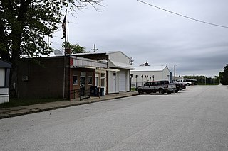
Manchester is a city in Dickinson County, Kansas, United States. As of the 2020 census, the population of the city was 47.

<span class="mw-page-title-main">Rantoul, Kansas</span> City in Franklin County, Kansas

Rantoul is a city in Franklin County, Kansas, United States. As of the 2020 census, the population of the city was 165.

<span class="mw-page-title-main">Cimarron, Kansas</span> City in Gray County, Kansas

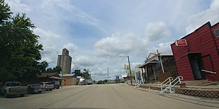
Cimarron is a city in and the county seat of Gray County, Kansas, United States. As of the 2020 census, the population of the city was 1,981. It is located along Highway 50.

<span class="mw-page-title-main">Burrton, Kansas</span> City in Harvey County, Kansas

Burrton is a city in Harvey County, Kansas, United States. It is named after Isaac T. Burr, former vice-president of the Atchison, Topeka and Santa Fe Railway. As of the 2020 census, the population of the city was 861.

<span class="mw-page-title-main">Halstead, Kansas</span> City in Harvey County, Kansas

Halstead is a city in Harvey County, Kansas, United States. Halstead was named in honor of Murat Halstead, a respected Civil War correspondent and newspaper editor. As of the 2020 census, the population of the city was 2,179.

<span class="mw-page-title-main">Gardner, Kansas</span> City in Kansas, United States

Gardner is a city in Johnson County, Kansas, United States. As of the 2020 census, the population of the city was 23,287. It is located within the Kansas City metropolitan area.

<span class="mw-page-title-main">La Cygne, Kansas</span> City in Kansas, United States

La Cygne is a city in Linn County, Kansas, United States, and situated along the Marais des Cygnes River. As of the 2020 census, the population of the city was 1,050. The city is named after the Marais des Cygnes River which is a French translation of an Osage appellation meaning "marsh of the swans".

<span class="mw-page-title-main">Meade, Kansas</span> City in Meade County, Kansas

Meade is a city in and the county seat of Meade County, Kansas, United States. As of the 2020 census, the population of the city was 1,505.

<span class="mw-page-title-main">Ness City, Kansas</span> City in Ness County, Kansas

Ness City is a city in and the county seat of Ness County, Kansas, United States. As of the 2020 census, the population of the city was 1,329. Ness City is famous for its four-story Old Ness County Bank Building located downtown, and nicknamed Skyscraper of the Plains.

<span class="mw-page-title-main">Lyndon, Kansas</span> City in Osage County, Kansas

Lyndon is a city in, and the county seat of Osage County, Kansas, United States. As of the 2020 census, the population of the city was 1,037.

<span class="mw-page-title-main">Belleville, Kansas</span> City in Republic County, Kansas

Belleville is a city in and the county seat of Republic County, Kansas, United States. As of the 2020 census, the population of the city was 2,007.

<span class="mw-page-title-main">Courtland, Kansas</span> City in Republic County, Kansas

Courtland is a city in Republic County, Kansas, United States. As of the 2020 census, the population of the city was 294.

<span class="mw-page-title-main">Hunnewell, Kansas</span> City in Sumner County, Kansas

Hunnewell is a city in Sumner County, Kansas, United States. As of the 2020 census, the population of the city was 44.

References

  1. 1 2 3 4 U.S. Geological Survey Geographic Names Information System: Edgerton, Kansas
  2. "2019 U.S. Gazetteer Files". United States Census Bureau. Retrieved July 24, 2020.
  3. 1 2 "Profile of Edgerton, Kansas in 2020". United States Census Bureau. Archived from the original on November 23, 2022. Retrieved November 22, 2022.
  4. Map of Logistics Park Kansas City; BNSF.
  5. History of the State of Kansas: Containing a Full Account of Its Growth from an Uninhabited Territory to a Wealthy and Important State. A. T. Andreas. 1883. p.  643.
  6. Gannett, Henry (1905). The Origin of Certain Place Names in the United States. Govt. Print. Off. pp.  114.
  7. BNSF's Plans For Edgerton Intermodal Facility Chug Along; Kansas City Business Journal; October 28, 2010.
  8. BNSF Railway opens Logistics Park Kansas City; The Kansas City Star; October 17, 2013.
  9. Shipping container makes world smaller, KC and world economy bigger; The Kansas City Star; January 13, 2014.
  10. "US Gazetteer files 2010". United States Census Bureau. Archived from the original on January 25, 2012. Retrieved July 6, 2012.
  11. "US Census Bureau, Table P16: HOUSEHOLD TYPE". data.census.gov. Retrieved January 2, 2024.
  12. 1 2 3 4 5 "US Census Bureau, Table DP1: PROFILE OF GENERAL POPULATION AND HOUSING CHARACTERISTICS". data.census.gov. Retrieved January 2, 2024.
  13. Bureau, US Census. "Gazetteer Files". Census.gov. Retrieved December 30, 2023.
  14. "US Census Bureau, Table P1: RACE". data.census.gov. Retrieved January 2, 2024.
  15. "US Census Bureau, Table P2: HISPANIC OR LATINO, AND NOT HISPANIC OR LATINO BY RACE". data.census.gov. Retrieved January 2, 2024.
  16. "US Census Bureau, Table S1101: HOUSEHOLDS AND FAMILIES". data.census.gov. Retrieved January 2, 2024.
  17. "US Census Bureau, Table S1501: EDUCATIONAL ATTAINMENT". data.census.gov. Retrieved January 2, 2024.
  18. "US Census Bureau, Table S1903: MEDIAN INCOME IN THE PAST 12 MONTHS (IN 2020 INFLATION-ADJUSTED DOLLARS)". data.census.gov. Retrieved January 2, 2024.
  19. "US Census Bureau, Table S2001: EARNINGS IN THE PAST 12 MONTHS (IN 2020 INFLATION-ADJUSTED DOLLARS)". data.census.gov. Retrieved January 2, 2024.
  20. "US Census Bureau, Table S1701: POVERTY STATUS IN THE PAST 12 MONTHS". data.census.gov. Retrieved January 2, 2024.
  21. "US Census Bureau, Table S1702: POVERTY STATUS IN THE PAST 12 MONTHS OF FAMILIES". data.census.gov. Retrieved January 2, 2024.
  22. "U.S. Census website". United States Census Bureau . Retrieved July 6, 2012.
  23. "U.S. Census website". United States Census Bureau . Retrieved January 31, 2008.
  24. "John Henry Balch". Kansas Historical Society. Retrieved April 1, 2016.

Further reading