
Acklington Park is a former civil parish, now in the parish of Acklington, Northumberland, England. It was the birthplace of John Rushworth who achieved fame in both England and during the formation of the United States of America for compiling a series of works called Historical Collections covering the English Civil Wars throughout the 17th century. His writings became a part of the library of Thomas Jefferson and the second Library of Congress. In 1951 the parish had a population of 33.

Beanley is a village and former civil parish, now in the parish of Hedgeley in the county of Northumberland, England. It is situated to the north-west of Alnwick, near Eglingham. In 1951 the parish had a population of 53.
Bebside is a village and former civil parish, now in the parish of Blyth, in Northumberland, in England. It is situated to the west of Blyth. It was formerly a mining village, the mine associated with the village operated between 1858 and 1926. It was served by Bebside railway station, from 1850 to 1964. In 1911 the parish had a population of 58.

Burradon is a village and former civil parish, now in the parish of Netherton, in Northumberland, England. It is about 14 miles (23 km) to the south-west of Alnwick. In 1951 the parish had a population of 53.
Brandon is a village and former civil parish, now in the parish of Ingram, in Northumberland, in England. It is about 9 miles (14 km) north-west of Alnwick and 8 miles (13 km) south of Wooler in the Breamish Valley, just off the A697 north of Powburn. In 1951 the parish had a population of 58.
Branton is a village and former civil parish, now in the parish of Ingram, in Northumberland, England. It is about 9 miles (14 km) west of Alnwick. In 1951 the parish had a population of 50.
Brunton is a village and former civil parish, now in the parish of Newton-by-the-Sea, in the county of Northumberland, England. It is about 7 miles (11 km) north of Alnwick, a short distance inland from the North Sea coast. In 1951 the parish had a population of 35.

Cambo is a village and former civil parish, now in the parish of Wallington Demesne, in Northumberland, England. It is about 11 miles (18 km) to the west of the county town of Morpeth at the junction of the B6342 and B6343 roads. The village was gifted along with the Wallington Estate to the National Trust by Sir Charles Philips Trevelyan in 1942, the first donation of its kind. It remains a National Trust village. In 1951 the parish had a population of 60.
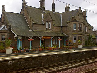
Chathill is a hamlet and former civil parish, now in the parish of Ellingham, in Northumberland, England. It is about 9 miles (14 km) north of Alnwick and 3 miles (5 km) inland from the North Sea coast. It is served by Chathill railway station. It is on the main road serving Seahouses and the northern coast. In 1951 the parish had a population of 59.
Clennell is a small village and as Clennel, a former civil parish, now in the parish of Alwinton, in Northumberland, England. It is about 1 mile (1.6 km) north-east of Alwinton. In 1951 the parish had a population of 37.
Hexhamshire Low Quarter is a former civil parish, now in the parish of Hexhamshire, in Northumberland, England. It was situated to the south of Hexham and to the north of Hexhamshire civil parish proper. The largest settlement in the parish was Juniper. In 1961 the parish had a population of 223.
Bassington is a former civil parish, now in the parish of Eglingham, in the county of Northumberland, England. It is located about 3 miles (5 km) northwest of Alnwick. Bassington is traversed by the River Aln. In 1951 the parish had a population of 2.
Mickley is a cluster of small settlements and former civil parish, now in the parish of Prudhoe, in the Tyne Valley, between Prudhoe and Stocksfield in the English county of Northumberland, England. It lies south of the River Tyne and is accessible via the A695. The electoral ward of Mickley comprises the hamlets of Mickley Square, West Mickley, High Mickley, plus Cherryburn and Eltringham Farm. The population is a little under one thousand. In 1951 the parish had a population of 1862.
Sharperton is a small settlement and former civil parish, now in the parish of Harbottle, in Northumberland, England. In 1951 the parish had a population of 36.
Stanton is a small hamlet and former civil parish, now in the parish of Netherwitton, in Northumberland, England, which is located 7 miles (11 km) north west of Morpeth, and 15 miles (24 km) north of Newcastle upon Tyne. Stanton is 9 miles (14 km) from the Northumberland National Park (NNPA). In 1951 the parish had a population of 70.
Broxfield is a hamlet and former civil parish, now in the parish of Rennington, in the county of Northumberland, England, off the B1340. In 1951 the parish had a population of 18.

Halton is a village and former civil parish, now in the parish of Whittington, in the southern part of Northumberland, England. It is situated 3 miles (4.8 km) north of Corbridge just south of Hadrian's Wall. In 1951 the parish had a population of 24.
Cooklaw is a small settlement and a former civil parish, now in the parish of Wall, in Northumberland, England. It is near the A6079 road and the River North Tyne. In 1951 the parish had a population of 119.

Horton is a former civil parish, now in the parish of Blyth, in Northumberland, England, about 2 miles (3 km) west of Blyth, and south of the River Blyth. Historically a chapelry of Woodhorn, it became part of Blyth Urban District in 1912, and in 1920 it was abolished, when it was combined with Bebside, Cowpen, and Newsham and South Blyth to form a single parish for the district. In 1911 the parish had a population of 2546.

Lanton is a hamlet and former civil parish, now in the parish of Ewart, in the north of the county of Northumberland, near the town of Wooler, the Cheviots and the Scottish Borders. The hamlet lies in the valley of Glendale, which takes its name from the River Glen. In 1951 the parish had a population of 56.

